 view gallery view gallery SW3.1 km SW3.1 km
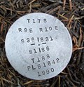
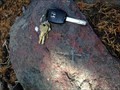
|   T17S R9E S36 R10E S31 T18S R9E S1 R10E S6 COR - Deschutes County, OR T17S R9E S36 R10E S31 T18S R9E S1 R10E S6 COR - Deschutes County, OR
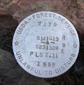
in Public Land Survey Marks PLSS township corner set by Robert M. Karl in 1980; National Forest Survey Corner Visitation Card, Index File No. 0151 posted by:  Cooke17513 Cooke17513 location: Oregon date approved: 08/18/2014 last visited: never |
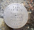 view gallery view gallery NW3.5 km NW3.5 km
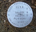
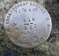
| T17S R9E S13 24 R10E S18 19 COR - Deschutes County, OR in Public Land Survey Marks PLSS section corner set by USDA-Forest Service, William B. Ham in 2002 posted by: Cooke17513 location: Oregon date approved: 10/15/2014 last visited: never |
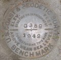
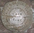
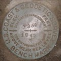
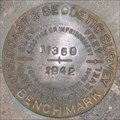
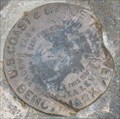 view gallery view galleryNW3.7 km |  QD1055 - USCGS J359, Oregon QD1055 - USCGS J359, Oregon
in U.S. Benchmarks U.S. Coast & Geodetic Survey Benchmark J359.
posted by: Volcanoguy location: Oregon date approved: 01/25/2009 last visited: 01/25/2009 |
 view gallery view gallery W3.7 km W3.7 km
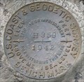
| QD1056 - USCGS H359, Oregon in U.S. Benchmarks U.S. Coast & Geodetic Survey Benchmark H359. posted by: Volcanoguy location: Oregon date approved: 01/25/2009 last visited: 01/25/2009 |
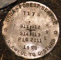
 view gallery view galleryW3.9 km | T17S R9E S26 25 36 35 COR - Deschutes County, OR in Public Land Survey Marks PLSS section corner set by USDA-Forest Service, Walt Miller in 1998; National Forest Survey Corner Visitation Card, Index File No. 2171 posted by: Cooke17513 location: Oregon date approved: 08/24/2014 last visited: 08/10/2015 |
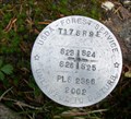 view gallery view galleryW4 km | T17S R9E S23 24 25 26 COR - Deschutes County, OR in Public Land Survey Marks PLSS section corner set by USDA - Forest Service, William B. Ham in 2002; National Forest Survey Corner Visitation Card, Index File No. 2167 posted by: Cooke17513 location: Oregon date approved: 08/20/2014 last visited: never |
 view gallery view gallery S4.2 km S4.2 km
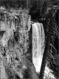
|  Tumalo Falls - Bend, Oregon, U.S.A. Tumalo Falls - Bend, Oregon, U.S.A.
in Waterfalls Tumalo Falls is a true waterfall. posted by: Wood Carver location: Oregon date approved: 08/23/2013 last visited: 08/12/2013 |
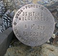 view gallery view galleryNW4.3 km | AP 329 3SISTERS WILDERNESS in U.S. Benchmarks Angle point located on the Three Sisters Wilderness boundary (Tract 3SWA) set by USDA-Forest Service, William Ham in 2005 posted by: Cooke17513 location: Oregon date approved: 08/26/2014 last visited: 08/10/2015 |
 view gallery view galleryNW4.3 km | T17S R9E S23 24 1/4 COR - Deschutes County, OR in Public Land Survey Marks PLSS quarter corner set by USDA-Forest Service, William Ham in 2002; National Forest Survey Corner Visitation Card, Index File No. 2165 posted by: Cooke17513 location: Oregon date approved: 08/24/2014 last visited: never |
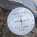
 view gallery view galleryW4.3 km | QD1057 - USCGS G359, Oregon in U.S. Benchmarks U.S. Coast & Geodetic Survey Benchmark G359. posted by: Volcanoguy location: Oregon date approved: 01/25/2009 last visited: 01/25/2009 |
 view gallery view galleryNW4.7 km | T17S R9E S14 13 24 23 COR - Deschutes County, OR in Public Land Survey Marks PLSS section corner set by USDA-Forest Service, Walt Miller in 1998; National Forest Survey Corner Visitation Card, Index File No. 2163 posted by: Cooke17513 location: Oregon date approved: 08/24/2014 last visited: never |
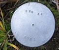
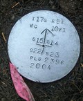
 view gallery view galleryNW5.1 km | T17S R9E S23 N 1/16 COR - Deschutes County, OR in Public Land Survey Marks PLSS sixteenth corner set by USDA-Forest Service, William Ham in 2004 posted by: Cooke17513 location: Oregon date approved: 09/09/2014 last visited: 10/19/2014 |
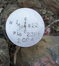
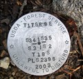
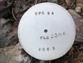 view gallery view galleryNW5.1 km | GPS 84 PLS 2396 2003 - Deschutes County, OR in U.S. Benchmarks 3-1/4" aluminum cap on 5/8" rebar set by USDA-Forest Service, William B. Ham in 2003; driven flush to the ground posted by: Cooke17513 location: Oregon date approved: 10/29/2014 last visited: never |
 view gallery view galleryNW5.3 km | QD1053 - USCGS L359, Oregon in U.S. Benchmarks U.S. Coast & Geodetic Survey Benchmark L359.
posted by: Volcanoguy location: Oregon date approved: 01/25/2009 last visited: 01/25/2009 |
 view gallery view galleryNW5.3 km | T17S R9E S14 23 1/4 COR - Deschutes County, OR in Public Land Survey Marks PLSS quarter corner set by USDA-Forest Service, William Ham in 2004 posted by: Cooke17513 location: Oregon date approved: 09/09/2014 last visited: 10/19/2014 |
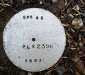 view gallery view galleryNW5.3 km | GPS 85 PLS 2396 2003 - Deschutes County, OR in U.S. Benchmarks 3-1/4" aluminum cap on 5/8" rebar set by USDA-Forest Service, William B. Ham in 2003; driven flush to ground posted by: Cooke17513 location: Oregon date approved: 10/29/2014 last visited: never |
 view gallery view galleryNW5.8 km | T 17 S, R 9 E, Section Corner 11, 12, 13, 14, Oregon in U.S. Benchmarks Cadastral cap for T 17 S, R 9 E, Section Corner 11, 12, 13, 14 posted by: Volcanoguy location: Oregon date approved: 01/25/2009 last visited: 08/19/2014 |
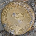 view gallery view galleryW5.8 km | QD1258 - USGS P-32, Oregon in U.S. Benchmarks U.S. Geological Survey elevation mark P-32. posted by: Volcanoguy location: Oregon date approved: 01/25/2009 last visited: 01/25/2009 |
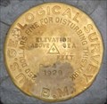 view gallery view galleryNW5.8 km | QD1052 - USGS P-4, Oregon in U.S. Benchmarks U.S. Geological Survey Benchmark P-4. posted by: Volcanoguy location: Oregon date approved: 01/25/2009 last visited: 01/25/2009 |
 view gallery view galleryW6 km | T17S R9E S34 35 T18S R9E S3 2 COR - Deschutes Country, OR in Public Land Survey Marks PLSS section corner set by USDA-Forest Service, William B. Ham in 2003 posted by: Cooke17513 location: Oregon date approved: 10/15/2014 last visited: never |
 view gallery view galleryW6 km | T17S R9E S22 23 N 1/16 COR - Deschutes County, OR in Public Land Survey Marks PLSS sixteenth corner set by USDA-Forest Service, William B, Ham; MONUMENT #10 on survey CS17230 filed in the Deschutes County Surveyors Office posted by: Cooke17513 location: Oregon date approved: 10/17/2015 last visited: never |
 view gallery view galleryW6 km | GPS 93 2003 - Deschutes County, OR in U.S. Benchmarks 3-1/4" aluminum cap on rebar set by USDA-Forest Service in 2003; driven flush to the ground posted by: Cooke17513 location: Oregon date approved: 10/16/2014 last visited: never |
 view gallery view galleryNW6.1 km | T17S R9E S15 14 22 23 COR WC - Deschutes County, OR in Public Land Survey Marks PLSS witness corner set by USDA-Forest Service, William Ham in 2004 posted by: Cooke17513 location: Oregon date approved: 09/09/2014 last visited: 10/02/2015 |
 view gallery view galleryW6.4 km | QD1243 - USCGS F359, Oregon in U.S. Benchmarks U.S. Coast & Geodetic Survey Benchmark F359. posted by: Volcanoguy location: Oregon date approved: 01/25/2009 last visited: 08/23/2020 |
 view gallery view galleryNW6.4 km | QD1051 - USCGS M359, Oregon in U.S. Benchmarks U.S. Coast & Geodetic Survey Benchmark M359. posted by: Volcanoguy location: Oregon date approved: 01/25/2009 last visited: 02/07/2009 |
|