 view gallery view gallery E0.2 km E0.2 km
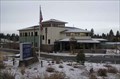
|   City Police Office - Bend, Oregon City Police Office - Bend, Oregon
in Police Stations The Bend City Police Office. posted by:  Volcanoguy Volcanoguy location: Oregon date approved: 03/02/2007 last visited: 03/02/2007 |
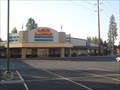 view gallery view galleryE0.3 km |  Lava Lanes - Bend, Oregon Lava Lanes - Bend, Oregon
in Bowling Centres Lava Lanes is located at the south base of Pilot Butte. posted by: Volcanoguy location: Oregon date approved: 11/12/2007 last visited: 11/14/2011 |
 view gallery view galleryE0.3 km |  Lava Lanes Penny Smasher Lava Lanes Penny Smasher
in Penny Smashers This four-design hand-cranked Penny Smasher is in Lava Lanes Bowling Center at 1555 Forbes Road in Bend, Oregon. posted by: brwhiz location: Oregon date approved: 02/21/2012 last visited: never |
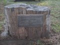 view gallery view galleryE0.3 km |  Ralph & Anna Yeaton - Pilot Butte Cemetery - Bend, Oregon Ralph & Anna Yeaton - Pilot Butte Cemetery - Bend, Oregon
in Homemade Tombstones Headstone is a large block of petrified wood. posted by: Volcanoguy location: Oregon date approved: 11/12/2007 last visited: 11/12/2007 |
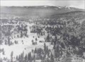 view gallery view gallery N0.5 km N0.5 km
|  Bend from Pilot Butte, Oregon Bend from Pilot Butte, Oregon
in Photos Then and Now View from near summit of Pilot Butte about 1912 and 2006. posted by: Volcanoguy location: Oregon date approved: 04/22/2006 last visited: 04/20/2007 |
 view gallery view gallery NW0.5 km NW0.5 km
|  Pilot Butte State Scenic Viewpoint - Oregon Pilot Butte State Scenic Viewpoint - Oregon
in State/Provincial Parks This scenic viewpoint is located in Bend, Oregon and provides a 360° view of central Oregon including the Cascade Peaks from Mt. Bachelor to Mt. Adams. posted by: Volcanoguy location: Oregon date approved: 05/29/2007 last visited: 06/06/2023 |
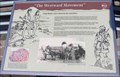
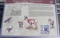 view gallery view galleryN0.5 km |  LEGACY - Oregon’s Fabled “High Desert” LEGACY - Oregon’s Fabled “High Desert”
in Oregon Historical Markers 2006 sign which was removed and replaced in 2016. posted by: Volcanoguy location: Oregon date approved: 09/17/2006 last visited: 04/20/2007 |
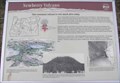 view gallery view galleryN0.5 km | LEGACY - Newberry Volcano in Oregon Historical Markers 2006 sign which was replaced in 2016. posted by: Volcanoguy location: Oregon date approved: 04/12/2006 last visited: 04/20/2007 |
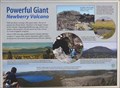 view gallery view galleryN0.5 km | Powerful Giant in Oregon Historical Markers New history sign on summit of Pilot Butte, replaces the old “Newberry Volcano” sign. posted by: Volcanoguy location: Oregon date approved: 09/06/2016 last visited: 08/13/2016 |
 view gallery view galleryN0.5 km | LEGACY - The Westward Movement in Oregon Historical Markers 2006 sign which was removed in 2016 and replaced with a wildlife sign. posted by: Volcanoguy location: Oregon date approved: 09/17/2006 last visited: 04/20/2007 |
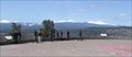 view gallery view galleryN0.5 km |  Pilot Butte Viewpoint, Oregon Pilot Butte Viewpoint, Oregon
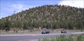
in Scenic Roadside Look-Outs Pilot Butte, in the center of Bend, provides a 360° view of central Oregon. Summit elevation of 4,138 feet. posted by: Volcanoguy location: Oregon date approved: 04/22/2006 last visited: 11/27/2020 |
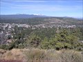 view gallery view galleryN0.5 km |  Bend, Oregon viewed from Pilot Butte Bend, Oregon viewed from Pilot Butte
in Cityscapes Pilot Butte, a 500-foot high cinder cone, is located on the east side of Bend and has a 360° view. posted by: Volcanoguy location: Oregon date approved: 09/17/2006 last visited: 05/20/2014 |
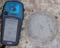
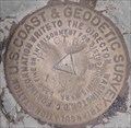 view gallery view galleryN0.5 km |  QD1681 - USCGS PILOT BUTTE, Oregon QD1681 - USCGS PILOT BUTTE, Oregon
in U.S. Benchmarks NGS PID QD1681 - USCGS PILOT BUTTE posted by: Volcanoguy location: Oregon date approved: 02/28/2007 last visited: 12/15/2021 |
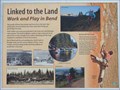 view gallery view galleryN0.5 km | Linked to the Land in Oregon Historical Markers New history sign on summit of Pilot Butte, replaces the old “The City of Bend” sign. posted by: Volcanoguy location: Oregon date approved: 09/06/2016 last visited: 08/13/2016 |
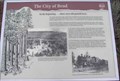 view gallery view galleryN0.5 km | LEGACY - The City of Bend in Oregon Historical Markers 2006 sign which was replaced in 2016 posted by: Volcanoguy location: Oregon date approved: 04/12/2006 last visited: 04/20/2007 |
 view gallery view gallery S0.5 km S0.5 km
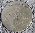
| T 17-18 S, R 12 E, Sec. corner 33, 34, 3, 4, Oregon in U.S. Benchmarks Cap for T 17-18 S, R 12 E, Sec. corner 33, 34, 3, 4, Oregon posted by: Volcanoguy location: Oregon date approved: 05/05/2006 last visited: 05/06/2006 |
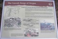 view gallery view galleryN0.5 km | LEGACY - The Cascade Range of Oregon in Oregon Historical Markers 2006 sign which was replaced in 2016. posted by: Volcanoguy location: Oregon date approved: 04/12/2006 last visited: 04/20/2007 |
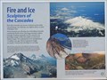 view gallery view galleryN0.5 km | Fire and Ice in Oregon Historical Markers New history sign on summit of Pilot Butte, replaces the old “The Cascade Range of Oregon” sign. posted by: Volcanoguy location: Oregon date approved: 09/06/2016 last visited: 08/13/2016 |
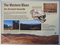 view gallery view galleryN0.5 km | The Western Blues in Oregon Historical Markers New history sign on summit of Pilot Butte, replaces the old “The Blue Mountains of Oregon” sign. posted by: Volcanoguy location: Oregon date approved: 09/06/2016 last visited: 08/13/2016 |
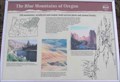 view gallery view galleryN0.5 km | LEGACY - The Blue Mountains of Oregon in Oregon Historical Markers 2006 sign which was replaced in 2016. posted by: Volcanoguy location: Oregon date approved: 04/12/2006 last visited: 04/20/2007 |
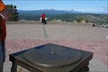 view gallery view galleryN0.6 km |  Pilot Butte Orientation Table - Bend, OR Pilot Butte Orientation Table - Bend, OR
in Orientation Tables This table is located on top of Pilot Butte in the Pilot Butte State park. From the location you can look around you to see the many mountains, cinder cones and volcanic craters that this portion of Oregon is known for. posted by:  Hikenutty Hikenutty location: Oregon date approved: 09/08/2008 last visited: 09/02/2013 |
 view gallery view galleryN0.6 km | GIS ECC#1, Oregon in U.S. Benchmarks Deschutes County GIS monument on summit of Pilot Butte. posted by: Volcanoguy location: Oregon date approved: 04/13/2006 last visited: 04/22/2006 |
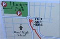 view gallery view gallery W0.6 km W0.6 km
|  Coyner Trail (North End) - Bend, Oregon Coyner Trail (North End) - Bend, Oregon
in 'You Are Here' Maps You Are Here marker on trail map at north end of Coyner Trail. posted by: Volcanoguy location: Oregon date approved: 11/03/2017 last visited: 11/03/2017 |
 view gallery view galleryW0.6 km |  Franklin’s Corner Bike Tender - Bend, Oregon Franklin’s Corner Bike Tender - Bend, Oregon
in Bicycle Tenders Bicycle Tender at the Franklin’s Corner Community Garden. posted by: Volcanoguy location: Oregon date approved: 11/03/2017 last visited: 11/03/2017 |
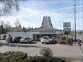 view gallery view galleryNW0.6 km |  The Pilot Butte Drive-In - Bend, Oregon The Pilot Butte Drive-In - Bend, Oregon
in Best Burgers in Town The Pilot Butte Drive-In is located at the base of Pilot Butte. posted by: Volcanoguy location: Oregon date approved: 02/04/2009 last visited: 02/02/2009 |
|