 view gallery view gallery N2.3 km N2.3 km
|   Sick-N-Twisted Micro Brewery - Hill City, South Dakota Sick-N-Twisted Micro Brewery - Hill City, South Dakota
in Brewpubs a micro brewery located on highway 385 in the city of Hill City (South Dakota) USA posted by:  oiseau_ca oiseau_ca location: South Dakota date approved: 09/10/2014 last visited: 06/23/2019 |
 view gallery view galleryN2.3 km |  International R-185 Fire Pumper - Hill City, South Dakota International R-185 Fire Pumper - Hill City, South Dakota
in Fire Fighting Vehicles an International R-185 Fire Pumper located on highway 385 in Hill City (South Dakota) USA posted by: oiseau_ca location: South Dakota date approved: 09/10/2014 last visited: 06/26/2015 |
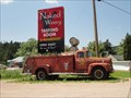
 view gallery view galleryN2.3 km |  Naked Winery - Hill City, South Dakota Naked Winery - Hill City, South Dakota
in Wineries a winery located on highway 385 in the city of Hill City (South Dakota) USA posted by: oiseau_ca location: South Dakota date approved: 09/09/2014 last visited: 06/26/2015 |
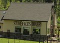 view gallery view gallery NW2.3 km NW2.3 km
| Stone Faces Winery - Hill City, South Dakota in Wineries a winery located on Highway 385 in Hill City (South Dakota) USA posted by: oiseau_ca location: South Dakota date approved: 09/09/2014 last visited: 06/23/2019 |
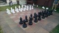 view gallery view gallery SW2.6 km SW2.6 km
|  Giant Chess Board, Palmer Gulch KOA, Keystone, South Dakota Giant Chess Board, Palmer Gulch KOA, Keystone, South Dakota
in Giant Board Games Large chessboard located near Mount Rushmore. posted by: paulspaper location: South Dakota date approved: 07/26/2016 last visited: never |
 view gallery view gallery W4.3 km W4.3 km
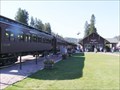
|  Black Hills Central Railroad - Hill City, SD Black Hills Central Railroad - Hill City, SD
in Wikipedia Entries The Black Hills Central Railroad is a heritage railroad that operates in Keystone, South Dakota.
It currently operates the 1880 Train on the former Keystone Branch of the Burlington Northern Railroad (BN) between Hill City, South Dakota. posted by:  Don.Morfe Don.Morfe location: South Dakota date approved: 09/23/2021 last visited: 09/23/2021 |
 view gallery view galleryW4.3 km |  The Black Hills Central Railroad - Hill City, SD The Black Hills Central Railroad - Hill City, SD
in U.S. National Register of Historic Places The Black Hills Central Railroad has been placed on the National Register of Historic Places by the United States Department of the Interior 1893-The 1880 Train is the oldest continuously operating tourist train. It stops at the Hill City Depot. posted by: Don.Morfe location: South Dakota date approved: 12/27/2019 last visited: 09/27/2021 |
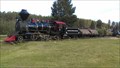 view gallery view galleryW4.3 km |  1880 Train - Hill City, SD 1880 Train - Hill City, SD
in Scenic Railroads A two-hour, relaxing 20-mile roundtrip ride between Hill City and Keystone through the Black Hills of South Dakota on a vintage steam train. posted by: Go Boilers! location: South Dakota date approved: 08/14/2016 last visited: 09/27/2021 |
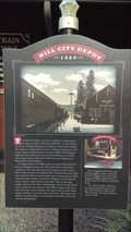 view gallery view galleryW4.3 km |  Hill City Depot - Hill City, SD Hill City Depot - Hill City, SD
in South Dakota Historical Markers The 1880 Train is the oldest continuously operating tourist train. It stops at the Hill City Depot. posted by: Go Boilers! location: South Dakota date approved: 08/14/2016 last visited: never |
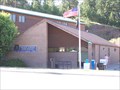 view gallery view galleryW4.3 km |  Hill City, South Dakota 57745 Hill City, South Dakota 57745
in U.S. Post Offices Small town post office. posted by: NGComets location: South Dakota date approved: 08/03/2011 last visited: 06/23/2019 |
 view gallery view gallery NE5.3 km NE5.3 km
| Sheridan ~ 1875 - 1942 in South Dakota Historical Markers Sheridan, located 1/2 mile NE from this sign is now 30 feet under water. posted by: MNSearchers location: South Dakota date approved: 06/12/2007 last visited: 08/20/2013 |
 view gallery view galleryNE5.3 km |  FIRST Gold Seekers in Sheridan - Pennington County, SD FIRST Gold Seekers in Sheridan - Pennington County, SD
in First of its Kind A 1958 South Dakota historical marker whose subject is the ghost town of Sheridan -- now under the waters in front of you -- notes the nine men who were the first gold seekers in the area, back in 1875. posted by: QuarrellaDeVil location: South Dakota date approved: 05/22/2020 last visited: never |
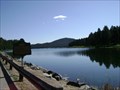
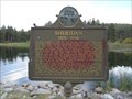 view gallery view galleryNE5.3 km |  Sheridan, SD Sheridan, SD
in Ghost Towns A 1958 South Dakota historical marker stands near the southeast end of Sheridan Lake, noting that the town of Sheridan stood here from 1875 until it was submerged by this lake in 1942. posted by: QuarrellaDeVil location: South Dakota date approved: 05/23/2020 last visited: never |
 view gallery view gallery S6.8 km S6.8 km
|  South Dakota's High Point - Harney Peak (alt. 7,242 feet) South Dakota's High Point - Harney Peak (alt. 7,242 feet)
in Geographic High Points The highest point in South Dakota! Not only is Harney Peak the tallest point of this plains state, but it also has the distinction of being the highest point east of the Rocky Mountains and west of the Pyrenees Mountains in Europe. posted by: Geoboss location: South Dakota date approved: 03/20/2011 last visited: 06/12/2023 |
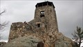
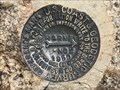
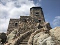 view gallery view galleryS6.8 km |  HARNEY PEAK LOOKOUT TOWER (OT0812) - Pennington County, South Dakota HARNEY PEAK LOOKOUT TOWER (OT0812) - Pennington County, South Dakota
in U.S. Benchmarks This unique fire lookout tower has been built on the summit of Black Elk Peak (previously Harney Peak), the highest point in South Dakota. posted by: Tom.dog location: South Dakota date approved: 06/17/2023 last visited: never |
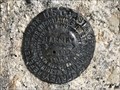 view gallery view galleryS6.8 km | HARNEY NO 1 - Pennington County, South Dakota in U.S. Benchmarks Reference mark 1 for triangulation station HARNEY (OT0810). posted by: Tom.dog location: South Dakota date approved: 06/17/2023 last visited: never |
 view gallery view galleryS6.8 km | HARNEY NO 2 - Pennington County, South Dakota in U.S. Benchmarks Reference mark 2 for triangulation station HARNEY (OT0810). posted by: Tom.dog location: South Dakota date approved: 06/17/2023 last visited: never |
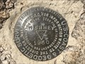 view gallery view galleryS6.8 km | HARNEY (OT0810) - Pennington County, South Dakota in U.S. Benchmarks A triangulation station on a sub-summit of Black Elk Peak, the highest point in the state of South Dakota. posted by: Tom.dog location: South Dakota date approved: 06/17/2023 last visited: never |
 view gallery view gallery SE7.4 km SE7.4 km
|  Profile in Granite - Keystone, SD Profile in Granite - Keystone, SD
in Scenic Roadside Look-Outs A roadside pullout just south of Mt. Rushmore along SD 244 gives a tremendous view of George Washington's profile, and an interpretive sign entitled "Profile in Granite" will tell you all about it. posted by: QuarrellaDeVil location: South Dakota date approved: 05/22/2020 last visited: 03/23/2020 |
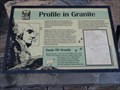 view gallery view gallerySE7.4 km | Profile in Granite - Keystone, SD in South Dakota Historical Markers An interpretive sign stands in a roadside pullout along SD 244, providing a little background on George Washington's profile, of which you get a great view while standing here. posted by: QuarrellaDeVil location: South Dakota date approved: 05/23/2020 last visited: 06/09/2021 |
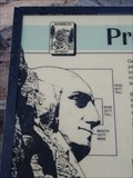 view gallery view gallerySE7.4 km |  Profile in Granite - Keystone, SD Profile in Granite - Keystone, SD
in George Washington An interpretive sign stands in a roadside pullout along SD 244, providing a little background on George Washington's profile on Mt. Rushmore, of which you get a great view while standing here. George's face dominates the left third of the sign. posted by: QuarrellaDeVil location: South Dakota date approved: 05/22/2020 last visited: 01/03/2022 |
 view gallery view gallerySE7.4 km |  Peter Norbeck Scenic Byway - Profile in Granite - Keystone, SD Peter Norbeck Scenic Byway - Profile in Granite - Keystone, SD
in National Scenic Byways A roadside pullout just south of Mt. Rushmore along the Peter Norbeck Scenic Byway gives a tremendous view of George Washington's profile, and an interpretive sign entitled "Profile in Granite" will tell you all about it. posted by: QuarrellaDeVil location: South Dakota date approved: 05/23/2020 last visited: 03/23/2020 |
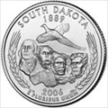 view gallery view gallerySE7.4 km |  Mount Rushmore - South Dakota, USA Mount Rushmore - South Dakota, USA
in Numismatic Photographs Mount Rushmore is featured on the South Dakota state quarter. posted by: Go Boilers! location: South Dakota date approved: 11/27/2011 last visited: 08/11/2023 |
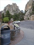
 view gallery view gallerySE7.6 km |  Mount Rushmore Presidential Trail - Mount Rushmore, South Dakota Mount Rushmore Presidential Trail - Mount Rushmore, South Dakota
in Hiking and walking trailheads the head of Presidential Trail located at the Mount Rushmore National Memorial (South Dakota) USA posted by: oiseau_ca location: South Dakota date approved: 09/07/2014 last visited: 08/11/2023 |
 view gallery view gallerySE7.6 km |  You are here - Mount Rushmore, South Dakota You are here - Mount Rushmore, South Dakota
in 'You Are Here' Maps You are here at the head of Presidential Trail located at the Mount Rushmore National Memorial (South Dakota) USA posted by: oiseau_ca location: South Dakota date approved: 09/08/2014 last visited: 08/11/2023 |
|