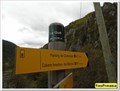
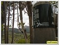
 view gallery view gallery N1.6 km N1.6 km
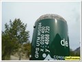
|   1130 m - Le Gué - Senez, France 1130 m - Le Gué - Senez, France
in Elevation Signs Ces coordonnées sont sur un panneau à destination des randonneurs posted by:  YvesProvence YvesProvence location: Provence-Alpes-Côte d'Azur, France date approved: 05/12/2019 last visited: never |
 view gallery view galleryN1.6 km |  43°55'40.7"N 6°17'15.3"E - Le Gué - Senez, France 43°55'40.7"N 6°17'15.3"E - Le Gué - Senez, France
in Permanent Geographic Coordinates Ces coordonnées sont sur un panneau à destination des randonneurs posted by: YvesProvence location: Provence-Alpes-Côte d'Azur, France date approved: 05/12/2019 last visited: never |
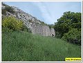
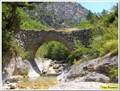
 view gallery view galleryN1.6 km |  Le pont du Ravin de la Font des Prés - Senes, France Le pont du Ravin de la Font des Prés - Senes, France
in Stone Bridges Le pont de pierres, en arche du ravin de la Font des Prés, à Senez posted by: YvesProvence location: Provence-Alpes-Côte d'Azur, France date approved: 05/13/2019 last visited: never |
 view gallery view galleryN1.6 km |  Le pont du Ravin de la Font des Prés - Senes, France Le pont du Ravin de la Font des Prés - Senes, France
in Arch Bridges Le pont de pierres, en arche du ravin de la Font des Prés, à Senez posted by: YvesProvence location: Provence-Alpes-Côte d'Azur, France date approved: 05/13/2019 last visited: never |
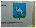
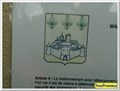 view gallery view galleryN2.6 km |  Blason de Senez - Hameau du Poil, France Blason de Senez - Hameau du Poil, France
in Coats of Arms Le blason de Senez, au hameau abandonné du Poil posted by: YvesProvence location: Provence-Alpes-Côte d'Azur, France date approved: 05/12/2019 last visited: never |
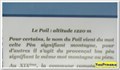
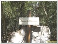
 view gallery view galleryN2.6 km | Blason du Poil - Le Poil, Senez, France in Coats of Arms Le blason du hameau abandonné sur un panneau d'affichage municipal posted by: YvesProvence location: Provence-Alpes-Côte d'Azur, France date approved: 05/12/2019 last visited: never |
 view gallery view galleryN2.6 km | 1220 m - Le Poil - Senez, France in Elevation Signs L'altitude présente sur la panneau de présentation du hameau abandonné du Poil posted by: YvesProvence location: Provence-Alpes-Côte d'Azur, France date approved: 05/12/2019 last visited: never |
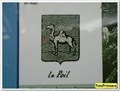 view gallery view galleryN2.6 km | Blason du Poil - Senez, France in Coats of Arms Le blason du Poil sur un panneau de présentation du hameau abandonné posted by: YvesProvence location: Provence-Alpes-Côte d'Azur, France date approved: 05/12/2019 last visited: never |
 view gallery view galleryN2.7 km | 1210 m - Le Poil - Senez, France in Elevation Signs Ces coordonnées sont sur un panneau à destination des randonneurs posted by: YvesProvence location: Provence-Alpes-Côte d'Azur, France date approved: 05/12/2019 last visited: never |
 view gallery view galleryN2.7 km | 43°56'13.6"N 6°17'05.6"E - Le Poil - Senez, France in Permanent Geographic Coordinates Ces coordonnées sont sur un panneau à destination des randonneurs posted by: YvesProvence location: Provence-Alpes-Côte d'Azur, France date approved: 05/12/2019 last visited: never |
 view gallery view galleryN2.7 km |  Le Poil - Senes, Paca, France Le Poil - Senes, Paca, France
in Ghost Towns Le Poil est ancienne commune française, dans les Alpes-de-Haute-Provence en région Provence-Alpes-Côte d'Azur, France posted by: YvesProvence location: Provence-Alpes-Côte d'Azur, France date approved: 08/04/2017 last visited: 05/11/2019 |
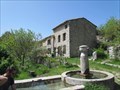
 view gallery view galleryN2.7 km |  La fontaine du Poil - Senez, France La fontaine du Poil - Senez, France
in Fountains La fontaine du village posted by: YvesProvence location: Provence-Alpes-Côte d'Azur, France date approved: 03/06/2018 last visited: never |
 view gallery view galleryN2.7 km | ") Le lavoir du Poil - Senez, France Le lavoir du Poil - Senez, France
in Lavoir (wash houses) Le lavoir du village posted by: YvesProvence location: Provence-Alpes-Côte d'Azur, France date approved: 03/06/2018 last visited: 05/11/2019 |
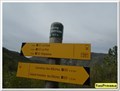 view gallery view gallery NW3.4 km NW3.4 km
| 1017 m - Parking du Chabrejas - Senez, France in Elevation Signs Cette altitude est présente sur un panneau à destination des randonneurs posted by: YvesProvence location: Provence-Alpes-Côte d'Azur, France date approved: 05/12/2019 last visited: never |
 view gallery view galleryNW3.4 km | 43°56'19.6"N 6°15'51.8"E - Parking du Chabrejas - Senez, France in Permanent Geographic Coordinates Cette altitude est présente sur un panneau à destination des randonneurs posted by: YvesProvence location: Provence-Alpes-Côte d'Azur, France date approved: 05/12/2019 last visited: never |
 view gallery view galleryNW4.3 km | Hameau de Valbonnette - Estoublon, Paca, France in Ghost Towns Le hameau abandonné de Valbonnette, sur la commune d'Estoublon posted by: YvesProvence location: Provence-Alpes-Côte d'Azur, France date approved: 07/11/2017 last visited: never |
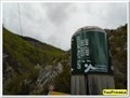
 view gallery view galleryNW5 km |  Repère de nivellement - I'.C.O3 - 112 - Senes, France Repère de nivellement - I'.C.O3 - 112 - Senes, France
in French Benchmarks Un repère de nivellement près du pont posted by: YvesProvence location: Provence-Alpes-Côte d'Azur, France date approved: 05/12/2019 last visited: never |
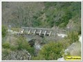
 view gallery view galleryNW5 km | Le pont de la clue du Pas d'Escale - Senez, France in Arch Bridges Ce pont est à la clue du Pas d'Escale, sur la D17 à Senez posted by: YvesProvence location: Provence-Alpes-Côte d'Azur, France date approved: 05/13/2019 last visited: never |
 view gallery view galleryNW5 km | Le pont de la clue du Pas d'Escale - Senez, France in Stone Bridges Ce pont est à la clue du Pas d'Escale, sur la D17 à Senez posted by: YvesProvence location: Provence-Alpes-Côte d'Azur, France date approved: 05/13/2019 last visited: never |
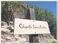
 view gallery view galleryNW5.3 km |  La chapelle Saint André - Estoublon, Paca, France La chapelle Saint André - Estoublon, Paca, France
in Roman Catholic Churches La chapelle Saint André dont les ruines surplombent d’un côté les magnifiques gorges de l’Estoublaïsse, de l’autre, le ravin du pas de l’Escale où coule le Clovion. posted by: YvesProvence location: Provence-Alpes-Côte d'Azur, France date approved: 07/10/2017 last visited: never |
 view gallery view galleryNW5.3 km |  La chapelle Saint André - Estoublon, Paca, France La chapelle Saint André - Estoublon, Paca, France
in Medieval Churches La chapelle Saint André dont les ruines surplombent d’un côté les magnifiques gorges de l’Estoublaïsse, de l’autre, le ravin du pas de l’Escale où coule le Clovion. posted by: YvesProvence location: Provence-Alpes-Côte d'Azur, France date approved: 07/10/2017 last visited: never |
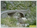
 view gallery view galleryNW5.5 km | Le pont romain - Estoublon, Paca, France in Arch Bridges Le pont romain, en bas du ravin du Pas de l'Escale, en contrebas de la D17 posted by: YvesProvence location: Provence-Alpes-Côte d'Azur, France date approved: 07/10/2017 last visited: never |
 view gallery view galleryNW5.5 km |  Le pont romain - Estoublon, Paca, France Le pont romain - Estoublon, Paca, France
in Hiking Path Footbridges Le pont romain, en bas du ravin du Pas de l'Escale, en contrebas de la D17 posted by: YvesProvence location: Provence-Alpes-Côte d'Azur, France date approved: 07/10/2017 last visited: never |
 view gallery view galleryNW5.5 km | Le pont romain - Estoublon, Paca, France in Stone Bridges Le pont romain, en bas du ravin du Pas de l'Escale, en contrebas de la D17 posted by: YvesProvence location: Provence-Alpes-Côte d'Azur, France date approved: 07/22/2017 last visited: never |
 view gallery view gallery SE5.5 km SE5.5 km
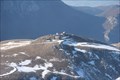
|  Observatoire du Mont Chiran Observatoire du Mont Chiran
in Astronomical Observatories Toujours en activité, géré par l'ABCDE. posted by:  Asse2Blx Asse2Blx location: Provence-Alpes-Côte d'Azur, France date approved: 04/26/2012 last visited: never |
|