 view gallery view gallery S1 km S1 km
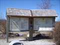
|   Elora-Cataract Trailway access point, Station Street, Hillsburgh Elora-Cataract Trailway access point, Station Street, Hillsburgh
in Hiking and walking trailheads This trailhead on Station Street in the town of Hillsburgh. posted by:  J.A.R.S. J.A.R.S. location: Ontario, Canada date approved: 03/23/2009 last visited: never |
 view gallery view gallery SE5.3 km SE5.3 km
|  8th Line Bridge - Erin, ON 8th Line Bridge - Erin, ON
in Arch Bridges Small arch bridge near Erin posted by:  stinger503 stinger503 location: Ontario, Canada date approved: 03/01/2022 last visited: never |
 view gallery view gallery E5.8 km E5.8 km
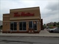
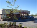
|  Tim Hortons - Wellington Road - Erin, ON Tim Hortons - Wellington Road - Erin, ON
in Tim Horton's Restaurants A newer Tim Hortons in Erin posted by: stinger503 location: Ontario, Canada date approved: 10/12/2013 last visited: never |
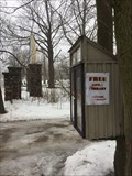 view gallery view galleryE6.1 km |  Main Street - Erin, Ontario Main Street - Erin, Ontario
in Free Community Book Exchanges Unregistered. Attached to a multi-trunk tree by a driveway. Next to the Stanley Park arch. posted by: J.A.R.S. location: Ontario, Canada date approved: 03/07/2017 last visited: never |
 view gallery view galleryE6.3 km | Elora-Cataract Trail access point, Ross Street, Erin in Hiking and walking trailheads This trailhead is on Ross Street in the town of Erin.
posted by: J.A.R.S. location: Ontario, Canada date approved: 03/23/2009 last visited: never |
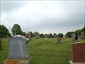
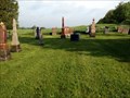 view gallery view gallery SW6.9 km SW6.9 km
|  Disciple Church Cemetery - Wellington County, ON Disciple Church Cemetery - Wellington County, ON
in Worldwide Cemeteries Small former churchyard cemetery posted by: stinger503 location: Ontario, Canada date approved: 07/15/2013 last visited: never |
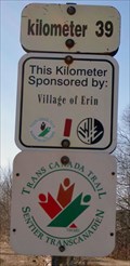
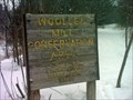 view gallery view galleryE7.4 km | Woolen Mill Lane trailhead, Woolen Mill Conservation Area in Hiking and walking trailheads Includes a short historical interpretive loop of mill history in the Village of Erin. posted by: J.A.R.S. location: Ontario, Canada date approved: 03/01/2011 last visited: never |
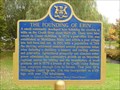 view gallery view galleryE7.6 km |  "THE FOUNDING OF ERIN" "THE FOUNDING OF ERIN"
in Ontario Provincial Plaques Located along the Main Street of Erin, north side of the river. posted by: Timo Explorer location: Ontario, Canada date approved: 10/14/2010 last visited: 05/29/2013 |
 view gallery view gallerySE7.9 km |  Upper Credit Humane Society Upper Credit Humane Society
in Humane Societies and Rescues Servince Wellington County and North Halton posted by: northernpenguin location: Ontario, Canada date approved: 09/10/2008 last visited: 03/19/2015 |
 view gallery view galleryE8 km | Elora-Cataract Trail access point, Winston Churchill Blvd, Caledon in Hiking and walking trailheads Elora-Cataract Trail access point on Winston Churchill Blvd in the town of Caledon, Ontario. posted by: J.A.R.S. location: Ontario, Canada date approved: 03/26/2009 last visited: never |
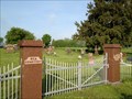
 view gallery view gallerySE8.7 km | Erin Cemetery - Erin, ON in Worldwide Cemeteries Town cemetery in Erin posted by: stinger503 location: Ontario, Canada date approved: 10/11/2013 last visited: 03/19/2015 |
 view gallery view gallery N10.1 km N10.1 km
|  Shoe Trees - Orangeville, Ontario, Canada Shoe Trees - Orangeville, Ontario, Canada
in Shoe Trees Collection of shoe trees along Orangeville - Caledon Tline just west of Orangeville, Ontario. posted by: monkeys4ever location: Ontario, Canada date approved: 05/06/2009 last visited: 06/01/2010 |
 view gallery view gallerySW10.3 km | Rea Cemetery - Wellington County, Ontario in Worldwide Cemeteries Large rural cemetery north-east of Guelph posted by: stinger503 location: Ontario, Canada date approved: 07/15/2013 last visited: never |
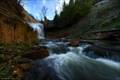 view gallery view galleryE10.6 km |  Churches Falls, Caledon, ON Churches Falls, Caledon, ON
in Waterfalls An impressive plunge type waterfall in Forks of the Credit park. posted by: northernpenguin location: Ontario, Canada date approved: 08/31/2008 last visited: 06/16/2021 |
 view gallery view galleryE10.8 km |  Red Telephone Boxes - Cataract Inn, Alton ON Red Telephone Boxes - Cataract Inn, Alton ON
in Red Telephone Boxes Placed in front of the Cataract Inn, a local place to dine. posted by: The Blue Quasar location: Ontario, Canada date approved: 05/13/2008 last visited: 11/10/2010 |
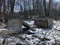
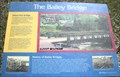 view gallery view galleryE10.8 km |  Bailey Bridge - Forks Of The Credit Park, Ontario Bailey Bridge - Forks Of The Credit Park, Ontario
in Truss Bridges An unusual pedestrian truss bridge in Forks Of The Credit Park, Ontario Canada posted by: Wolfmaan location: Ontario, Canada date approved: 05/12/2010 last visited: 06/16/2021 |
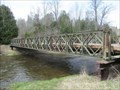 view gallery view galleryE10.8 km |  Credit River Bailey Bridge - Forks Of The Credit Park - Caledon, Ontario Credit River Bailey Bridge - Forks Of The Credit Park - Caledon, Ontario
in Bailey Bridges This Bailey bridge crosses over the Credit river in the Forks of the Credit Provincial Park, Caledon, Ontario. posted by: DougandSandra location: Ontario, Canada date approved: 05/13/2018 last visited: 06/16/2021 |
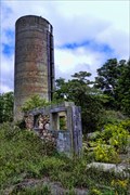 view gallery view galleryE11.1 km |  Remains of a stone barn and concrete silo - Belfountain, Ontario Remains of a stone barn and concrete silo - Belfountain, Ontario
in Remains of Settlements The silo still stands tall but not much remains of an old stone barn just outside of the village of Belfountain. posted by: ThePh@ntom location: Ontario, Canada date approved: 08/27/2010 last visited: 07/19/2015 |
 view gallery view galleryN11.9 km |  Orangeville - Ontario, Canada Orangeville - Ontario, Canada
in Population Signs Orangeville Pop: 26.000 posted by: monkeys4ever location: Ontario, Canada date approved: 07/19/2010 last visited: 01/16/2016 |
 view gallery view gallerySW12.2 km | Shiloh Bridge - Shiloh, ON in Arch Bridges Historic arch bridge in Shiloh posted by: stinger503 location: Ontario, Canada date approved: 09/19/2022 last visited: 09/21/2022 |
 view gallery view galleryN12.4 km | Tim Horton's - Centennial Road - Orangeville, Ontario, Canada in Tim Horton's Restaurants This Tim Horton's is located at 230 Centennial Road in Orangeville. posted by: monkeys4ever location: Ontario, Canada date approved: 07/12/2010 last visited: 12/09/2012 |
 view gallery view galleryE12.4 km |  Forks Of The Credit Provincial Park - Caledon, Ontario Forks Of The Credit Provincial Park - Caledon, Ontario
in State/Provincial Parks Hike the wonderful trails of the scenic Forks of the Credit Provincial Park. posted by: Timo Explorer location: Ontario, Canada date approved: 07/29/2009 last visited: 06/16/2021 |
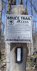 view gallery view galleryE13 km | Bruce Trail access point, Caledon Mountain Drive, Belfountain in Hiking and walking trailheads Access point to the Bruce Trail. Caledon Mountain Road, Belfountain (hamlet), Caledon (town), Ontario. posted by: J.A.R.S. location: Ontario, Canada date approved: 03/24/2009 last visited: 03/09/2022 |
 view gallery view gallery W13 km W13 km
|  Former Side Road 10 Bridge - Belwood, ON Former Side Road 10 Bridge - Belwood, ON
in Orphaned Bridges Abandoned bridge in Belwood posted by: stinger503 location: Ontario, Canada date approved: 05/01/2018 last visited: never |
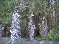
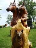 view gallery view galleryN13.4 km |  2 horses and a dog ~ Orangeville, Ontario CANADA 2 horses and a dog ~ Orangeville, Ontario CANADA
in Outside Wooden Display Carvings This is a carving for which there is no credit to be found YET!
It is the 4th for the Greenwood Cemetery. posted by: Jake39 location: Ontario, Canada date approved: 07/27/2010 last visited: never |
|