 view gallery view gallery SE17.5 km SE17.5 km
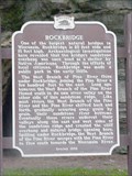
|   Rockbridge Rockbridge
in Wisconsin Historical Markers Rockbridge Historical Marker in Pier County Park off of Hwy 80 in Rockbridge posted by:  onfire4jesus onfire4jesus location: Wisconsin date approved: 04/24/2007 last visited: 01/30/2022 |
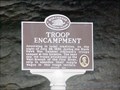 view gallery view gallerySE17.5 km | Troop Encampment in Wisconsin Historical Markers Troop Encampment Historical Marker in Pier County Park off of Hwy 80 in Rockbridge posted by: onfire4jesus location: Wisconsin date approved: 04/24/2007 last visited: 06/23/2012 |
 view gallery view gallery NE18.5 km NE18.5 km
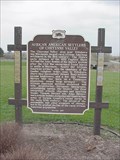
| African American Settlers of Cheyenne Valley in Wisconsin Historical Markers African American Settlers of Cheyenne Valley Historical Marker in the Cheyenne Settlers Historic Parknear 300 Water Ave. in Hillsboro posted by: onfire4jesus location: Wisconsin date approved: 04/23/2007 last visited: 06/05/2019 |
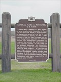 view gallery view galleryNE18.5 km | Admiral Marc A. Mitscher, U. S. Navy in Wisconsin Historical Markers Admiral Marc A. Mitscher, U. S. Navy Historical Marker in wayside on Hwy 33 just west of Hillsboro posted by: onfire4jesus location: Wisconsin date approved: 04/24/2007 last visited: 08/26/2007 |
 view gallery view gallery W20.9 km W20.9 km
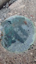
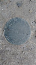
|  22 FDR 1962 RESET 1979 Bench Mark - Avalanche, WI 22 FDR 1962 RESET 1979 Bench Mark - Avalanche, WI
in U.S. Benchmarks This disk is set on a bridge on County Highway S that spans the West Fork Kickapoo River in Avalanche, WI. posted by: mrjcanger location: Wisconsin date approved: 10/20/2016 last visited: never |
 view gallery view gallery S22.7 km S22.7 km
| Rural Electrification in Wisconsin Historical Markers Rural Electrification Historical Marker in wayside on Hwy 14 east of Boaz posted by: onfire4jesus location: Wisconsin date approved: 04/24/2007 last visited: 11/29/2022 |
 view gallery view galleryS22.7 km |  FIRST - Wisconsin farm with rural electrical power FIRST - Wisconsin farm with rural electrical power
in First of its Kind This farm was the first in Wisconsin to obtain central station electric power from a rural electric cooperative posted by: onfire4jesus location: Wisconsin date approved: 08/10/2007 last visited: 11/29/2022 |
 view gallery view galleryS22.7 km | Boaz Mastodon in Wisconsin Historical Markers Boaz Mastodon Historical Marker in wayside on Hwy 14 east of Boaz posted by: onfire4jesus location: Wisconsin date approved: 04/24/2007 last visited: 11/29/2022 |
 view gallery view gallery SW23.2 km SW23.2 km
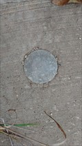
| 2S56 Control Station - Readstown, WI in U.S. Benchmarks Located on the Southeast wing wall of the bridge spanning the creek that flows from Spring Valley, this disk was set be the Wisconsin DOT in 2004 posted by: mrjcanger location: Wisconsin date approved: 10/14/2016 last visited: never |
 view gallery view gallerySW23.2 km | Spring Valley Elevation Disk - Readstown, WI in U.S. Benchmarks Set on a bridge that spans the creek flowing from Spring Valley, this disk shows a small portion of Wisconsin's highway history. posted by: mrjcanger location: Wisconsin date approved: 10/14/2016 last visited: never |
 view gallery view galleryW23.3 km | Maple Dale Vertical Control - Viroqua, WI in U.S. Benchmarks Located on a bridge that spans the small creek from Maple Dale and 7 Reservoir, this disk is located on the Southwest wing wall. posted by: mrjcanger location: Wisconsin date approved: 10/20/2016 last visited: never |
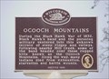 view gallery view galleryS23.7 km | Ocooch Mountains in Wisconsin Historical Markers Ocooch Mountains Historical Marker in Boaz Park on Hwy 171 in Boaz posted by: onfire4jesus location: Wisconsin date approved: 04/24/2007 last visited: 08/07/2018 |
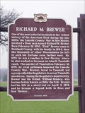 view gallery view galleryS23.7 km | Richard M. Brewer in Wisconsin Historical Markers Richard M. Brewer Historical Marker in Boaz Park on Hwy 171 in Boaz posted by: onfire4jesus location: Wisconsin date approved: 04/24/2007 last visited: 08/07/2018 |
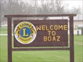 view gallery view galleryS24 km |  Boaz, Wi Boaz, Wi
in Names From the Bible The village of Boaz in Richland County, Wisconsin. Boaz married Ruth and was the father of Jesse, the father of King David posted by: onfire4jesus location: Wisconsin date approved: 04/30/2007 last visited: 08/07/2018 |
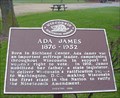 view gallery view gallerySE25.3 km | Ada James 1876 – 1952 in Wisconsin Historical Markers Ada James 1876 – 1952 Historical Marker in Krouskop Park at 400 W Sixth St (Hwy 14) in Richland Center posted by: onfire4jesus location: Wisconsin date approved: 04/24/2007 last visited: 08/07/2018 |
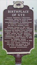 view gallery view gallerySE25.3 km | Birthplace of GTE in Wisconsin Historical Markers Birthplace of GTE Historical Marker in Krouskop Park at 400 W Sixth St (Hwy 14) in Richland Center posted by: onfire4jesus location: Wisconsin date approved: 04/24/2007 last visited: 08/07/2018 |
 view gallery view gallery NW25.4 km NW25.4 km
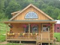
|  Inspirations at Dovetail Farm Inspirations at Dovetail Farm
in Quilt Shops Quilt shop in a log cabin in the midst of Amish country. posted by:  JMCQUILTER JMCQUILTER location: Wisconsin date approved: 11/22/2007 last visited: never |
 view gallery view galleryW25.6 km | Green Acres Vertical Control - Franklin Township, WI in U.S. Benchmarks Placed on the top of the Southwest wing wall of a bridge traversing Reads Creek, this disk marks a very good place to catch brown trout. posted by: mrjcanger location: Wisconsin date approved: 10/07/2016 last visited: never |
 view gallery view galleryW25.6 km | Seas Branch Vertical Control - Viroqua, WI in U.S. Benchmarks This disk is on the South side of County Highway Y on the wing wall o f a bridge spanning Seas Branch. posted by: mrjcanger location: Wisconsin date approved: 10/20/2016 last visited: never |
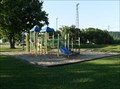 view gallery view gallerySW25.9 km |  Beauford T. Anderson Memorial Park Playground Beauford T. Anderson Memorial Park Playground
in Public Playgrounds Beauford T. Anderson Memorial Park Playground on Main St in Soldiers Grove, Wisconsin posted by: onfire4jesus location: Wisconsin date approved: 07/30/2007 last visited: 03/31/2013 |
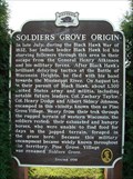 view gallery view gallerySW25.9 km | Soldiers Grove Origin Historical Marker in Wisconsin Historical Markers Soldiers Grove Origin Historical Marker in Park at Mill and Main Sts. in Soldiers Grove, WI posted by: onfire4jesus location: Wisconsin date approved: 08/16/2007 last visited: 03/31/2013 |
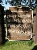 view gallery view gallerySW25.9 km | James Davidson Historical Marker in Wisconsin Historical Markers James Davidson Historical Marker posted by: onfire4jesus location: Wisconsin date approved: 08/16/2007 last visited: 10/03/2022 |
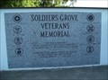 view gallery view gallerySW25.9 km |  Soldiers Grove Veterans Memorial Soldiers Grove Veterans Memorial
in Non-Specific Veteran Memorials Soldiers Grove Veterans Memorial in Beauford T. Anderson Memorial Park in Soldiers Grove, Wisconsin posted by: onfire4jesus location: Wisconsin date approved: 08/02/2007 last visited: 03/31/2013 |
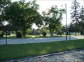 view gallery view gallerySW25.9 km |  Beauford T. Anderson Memorial Park - Soldiers Grove, WI Beauford T. Anderson Memorial Park - Soldiers Grove, WI
in Municipal Parks and Plazas Beauford T. Anderson Memorial Park on Main St. in Soldiers Grove, Wisconsin posted by: onfire4jesus location: Wisconsin date approved: 07/30/2007 last visited: 03/31/2013 |
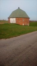 view gallery view galleryW27.2 km |  Cunningham, Bert and Mary, Round Bard - Viroqua, WI Cunningham, Bert and Mary, Round Bard - Viroqua, WI
in U.S. National Register of Historic Places Built in 1915, this barn is said to have been built around a pre-existing hollow tile silo. posted by: mrjcanger location: Wisconsin date approved: 11/07/2016 last visited: never |
|