 view gallery view gallery SE2.9 km SE2.9 km
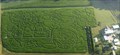
|   Treinen Farm Corn Maze And Pumpkin Patch Treinen Farm Corn Maze And Pumpkin Patch
in Outdoor Mazes Great corn maze each year in a 10 acre field. Also includes pumpkin patch, hay rides, and pumpkin slingshot. Open late at night, bring your flashlight. posted by:  ExecLink ExecLink location: Wisconsin date approved: 11/30/2005 last visited: 10/15/2010 |
 view gallery view gallery NE4.5 km NE4.5 km
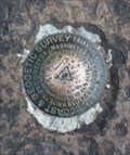
|  Gibralter - Gibralter Rock Park, WI Gibralter - Gibralter Rock Park, WI
in U.S. Benchmarks Located atop Gibralter Rock which provides a great view of the country side and Lake Wisconsin. posted by: bbqbomber location: Wisconsin date approved: 04/12/2015 last visited: 05/13/2015 |
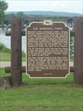 view gallery view galleryNE4.8 km |  Merrimac Ferry Merrimac Ferry
in Wisconsin Historical Markers The Merrimac Ferry, which crosses the Wisconsin River between Sauk and Columbia counties, is Wisconsin's only free ferry. It shuttles WIS 113 traffic 24 hours a day, 7 days a week, between Okee on the east bank and Merrimac on the west. posted by:  The Cheeseheads The Cheeseheads location: Wisconsin date approved: 08/16/2007 last visited: 04/04/2015 |
 view gallery view gallery N5.3 km N5.3 km
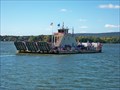
|  Merrimac Ferry - Merrimac, WI Merrimac Ferry - Merrimac, WI
in U.S. National Register of Historic Places One of the few places on the National Register that actually moves! posted by:  cldisme cldisme location: Wisconsin date approved: 09/24/2012 last visited: 04/04/2015 |
 view gallery view gallery SW6.6 km SW6.6 km
|  Wollersheim Winery - Prairie du Sac, WI Wollersheim Winery - Prairie du Sac, WI
in Wineries A winery on slopes overlooking the Wisconsin River. The views and the wine are both enjoyable. posted by: Go Boilers! location: Wisconsin date approved: 09/01/2008 last visited: never |
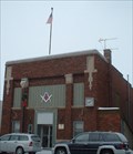 view gallery view gallerySW7.2 km |  Sauk Prairie Masonic Center No. 113 F.&A.M. Sauk Prairie Masonic Center No. 113 F.&A.M.
in Masonic Temples Sauk Prairie Masonic Center can be found at 580 Water St. posted by: Archived2012 location: Wisconsin date approved: 12/15/2007 last visited: 07/18/2012 |
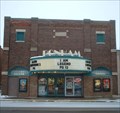 view gallery view gallerySW7.2 km |  Bonham Theatre - Prairie du Sac, WI Bonham Theatre - Prairie du Sac, WI
in Vintage Movie Theaters Bonham Theatre is located at 564 Water Street. posted by: Archived2012 location: Wisconsin date approved: 12/16/2007 last visited: 07/18/2012 |
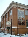 view gallery view gallerySW7.2 km |  Tripp Memorial Museum - Sauk Prairie Area Historical Society, WI Tripp Memorial Museum - Sauk Prairie Area Historical Society, WI
in History Museums The Tripp Memorial Museum - Sauk Prairie Area Historical Society can be found at 565 Water Street. posted by: Archived2012 location: Wisconsin date approved: 12/15/2007 last visited: 04/11/2014 |
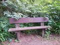
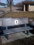 view gallery view gallerySW7.9 km |  LCpl. Nicholas Anderson - Sauk City, WI LCpl. Nicholas Anderson - Sauk City, WI
in Dedicated Benches Memorial bench located at the Sauk Prairie Area Veterans Memorial. posted by: kungfuhippie location: Wisconsin date approved: 02/20/2011 last visited: 07/18/2012 |
 view gallery view gallerySW7.9 km | August W. Derleth in Wisconsin Historical Markers August W Derleth park posted by: Not So Lost Puppies location: Wisconsin date approved: 10/24/2006 last visited: 04/05/2014 |
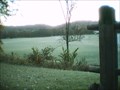
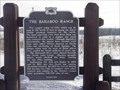 view gallery view gallery W9.2 km W9.2 km
| The Baraboo Range in Wisconsin Historical Markers A small pulloff just south of Devil's Lake State Park on WI-12. posted by: The Cheeseheads location: Wisconsin date approved: 03/05/2007 last visited: 03/02/2015 |
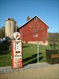 view gallery view galleryN9.3 km |  Tokheim 39 Gas Pump - Merrimac, Wisconsin Tokheim 39 Gas Pump - Merrimac, Wisconsin
in Vintage Gasoline Pumps This is not a Drive By! It's ok to stop and get out of your car and admire this beauty! posted by: Archived2012 location: Wisconsin date approved: 11/03/2007 last visited: never |
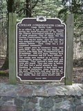
 view gallery view gallery NW10.8 km NW10.8 km
|  Civilian Conservation Corps Workers Monument - Devils Lake State Park, WI Civilian Conservation Corps Workers Monument - Devils Lake State Park, WI
in Occupational Monuments A statue and historical Marker commemorating the Civilian Conservation Corps workers at Devil's Lake State Park in Wisconsin posted by: onfire4jesus location: Georgia date approved: 08/29/2008 last visited: 08/31/2015 |
 view gallery view galleryNW10.8 km | Larry Schall Bench – Baraboo, WI in Dedicated Benches This bench is located near the historical marker and CCC statue in the area where a former CCC camp once stood. posted by: wildernessmama location: Wisconsin date approved: 07/24/2014 last visited: 08/31/2015 |
 view gallery view galleryNW10.8 km | Civilian Conservation Corps in Wisconsin Historical Markers Civilian Conservation Corps Historical Marker in Devils State Park posted by: onfire4jesus location: Wisconsin date approved: 04/08/2007 last visited: 07/04/2014 |
 view gallery view galleryNW10.8 km |  CCC Camp at Devil's Lake in Wisconsin CCC Camp at Devil's Lake in Wisconsin
in Civilian Conservation Corps A historical Marker and statue commemorating the CCC Camp at Devil's Lake State Park in Wisconsin posted by: onfire4jesus location: Wisconsin date approved: 08/09/2007 last visited: 08/31/2015 |
 view gallery view galleryNW10.8 km |  CCC Camp Devil's Lake Wisconsin CCC Camp Devil's Lake Wisconsin
in Photos Then and Now Look for the statue of a CCC camp "boy". The kiosk to your right shows the layout of the camp and provides information about life at the CCC at Devil's Lake. posted by: Devil's Lake location: Wisconsin date approved: 04/17/2011 last visited: 07/04/2014 |
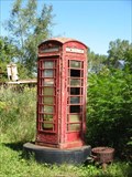 view gallery view galleryNW10.9 km |  Forevertron Phone Booth Forevertron Phone Booth
in Red Telephone Boxes Located in Bluffview, Wisconsin. posted by: Go Boilers! location: Wisconsin date approved: 09/03/2008 last visited: 07/04/2014 |
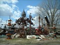 view gallery view galleryNW10.9 km |  The Forevertron The Forevertron
in Roadside Attractions Dr. Evermor (Tom Every) is a scrap artisan. He's built the World's Largest Sculpture on a science fiction landscape. posted by: Archived2012 location: Wisconsin date approved: 08/08/2007 last visited: 07/04/2014 |
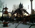 view gallery view galleryNW10.9 km |  The Forevertron The Forevertron
in Abstract Public Sculptures The world's largest scrap metal sculpture, in a sculpture park just south of Baraboo, Wisconsin posted by: The Cheeseheads location: Wisconsin date approved: 03/05/2007 last visited: 07/04/2014 |
 view gallery view gallerySW10.9 km | Battle of Wisconsin Heights in Wisconsin Historical Markers Black Hawk War site posted by: Not So Lost Puppies location: Wisconsin date approved: 10/24/2006 last visited: 09/09/2012 |
 view gallery view galleryNW11.3 km | Kirkland Hotel in Photos Then and Now Look for the rectanfular stones that are all that remains of this building. To find where the hotel was, locate the Thunderbird Effigy mound on the park's south shore. The hotel was built on the tip of one of the mound's wings. posted by: Devil's Lake location: Wisconsin date approved: 04/17/2011 last visited: never |
 view gallery view galleryNW11.3 km | Ringling Brothers Cottages in Photos Then and Now Look for the foundation of the buildings. South of the foundations, is a strip of wood nailed to a tree. This may have held a the sign "Sandy Beach", what the brother's called the cottages. posted by: Devil's Lake location: Wisconsin date approved: 04/17/2011 last visited: never |
 view gallery view galleryNW11.6 km | Kirland Home Animal Tunnel in Photos Then and Now You can find this from the East Bluff trail on the south shore of the park. Cross over the railroad tracks to a fork in the path. Ahead from the fork, you;ll see a side trail. Take this trail about 25 steps in to seveal spruce trees on the right. posted by: Devil's Lake location: Wisconsin date approved: 04/17/2011 last visited: never |
 view gallery view galleryNW12.2 km | UW Surveyors Camp in Photos Then and Now Look for the foundation of the barn and mess hall. Several concrete slabs make the trailers for the instructors' residences. posted by: Devil's Lake location: Wisconsin date approved: 04/17/2011 last visited: never |
|