 view gallery view gallery NW13 km NW13 km
|   Fort Rock, OR. 97735 Fort Rock, OR. 97735
in U.S. Post Offices The Fort Rock, OR Post Office. posted by:  Volcanoguy Volcanoguy location: Oregon date approved: 04/18/2008 last visited: 04/18/2008 |
 view gallery view galleryNW13.4 km |  Fort Rock State Monument, Oregon Fort Rock State Monument, Oregon
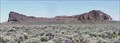
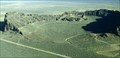
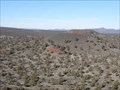
in U.S. National Natural Landmarks Fort Rock is a spectacular wave-cut feature standing on the floor of a pluvial lake basin. posted by: Volcanoguy location: Oregon date approved: 06/24/2006 last visited: 09/13/2010 |
 view gallery view galleryNW13.4 km |  Claiming the Desert Claiming the Desert
in Oregon Historical Markers Historical marker located outside the Fort Rock Village Historical Homestead Museum. posted by: TheBeanTeam location: Oregon date approved: 05/08/2007 last visited: 06/06/2007 |
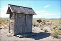 view gallery view galleryNW13.4 km |  Fort Rock Homestead Village Museum 3-holer; Fort Rock, OR Fort Rock Homestead Village Museum 3-holer; Fort Rock, OR
in Outhouses This 3-holer can be found at the wonderful little history museum, Homestead Village Museum, in Fort Rock, Oregon. posted by:  Hikenutty Hikenutty location: Oregon date approved: 09/08/2008 last visited: never |
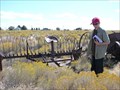 view gallery view galleryNW13.4 km |  Fort Rock Hay Rake and Misc. Equipment - Fort Rock, OR Fort Rock Hay Rake and Misc. Equipment - Fort Rock, OR
in Old Agricultural Equipment At the Fort Rock Homestead Museum there is an assortment of old farming equipment lying around to explore, including this hay rake behind the old church building. posted by: Hikenutty location: Oregon date approved: 09/22/2008 last visited: never |
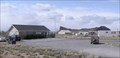
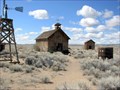
 view gallery view galleryNW13.4 km |  Outback Scenic Byway - Homestead Village Museum - Fort Rock, OR Outback Scenic Byway - Homestead Village Museum - Fort Rock, OR
in National Scenic Byways This is a small museum showcasing the homestead structures of the surrounding area. Walk around the village that they've created to see what it would have been like to live on a desert homestead in Central Oregon. posted by: Hikenutty location: Oregon date approved: 09/08/2008 last visited: never |
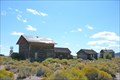
 view gallery view galleryNW13.4 km |  Fort Rock Homestead Village Fort Rock Homestead Village
in History Museums A desert museum honoring the pioneering spirit of homesteaders to the Fort Rock and surrounding areas. posted by: TheBeanTeam location: Oregon date approved: 06/18/2007 last visited: 02/03/2009 |
 view gallery view galleryNW13.4 km | Home Sweet Home in Oregon Historical Markers 2nd Historical Marker outside the Fort Rock Valley Historical Homestead Museum. posted by: TheBeanTeam location: Oregon date approved: 05/08/2007 last visited: 06/14/2007 |
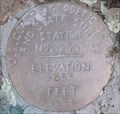
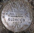
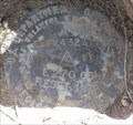 view gallery view galleryNW14.5 km |  USGS E270 OSH RESET, Oregon USGS E270 OSH RESET, Oregon
in U.S. Benchmarks U.S. Geological Survey Benchmark E270 OSH RESET posted by: Volcanoguy location: Oregon date approved: 06/15/2007 last visited: 06/15/2007 |
 view gallery view galleryNW14.5 km |  Fort Rock Cemetery, Fort Rock, Oregon, USA Fort Rock Cemetery, Fort Rock, Oregon, USA
in Worldwide Cemeteries Small cemetery for the homestead community of Fort Rock in the High Desert of Central Oregon. posted by: TheBeanTeam location: Oregon date approved: 05/02/2007 last visited: 06/15/2019 |
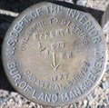 view gallery view galleryNW14.6 km | T 25 S, R 14 E, Center 1/4 of section 29, Oregon in U.S. Benchmarks Reference mark cap for T 25 S, R 14 E, center 1/4 corner of section 29. posted by: Volcanoguy location: Oregon date approved: 06/23/2006 last visited: 06/15/2019 |
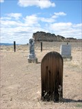 view gallery view galleryNW14.6 km |  Homemade Grave Markers, Fort Rock Cemetery, Fort Rock Oregon Homemade Grave Markers, Fort Rock Cemetery, Fort Rock Oregon
in Homemade Tombstones There are several graves that are marked with homemade grave markers in this homestead era cemetery in Central Oregon. posted by: TheBeanTeam location: Oregon date approved: 10/16/2007 last visited: 06/15/2019 |
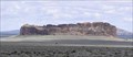
 view gallery view galleryNW14.6 km | Outback Scenic Byway - Fort Rock in National Scenic Byways Fort Rock (a National Natural Landmark) is located about 5 miles off the Outback Scenic Byway route and is a well known geologic feature along the route. posted by: Volcanoguy location: Oregon date approved: 05/24/2008 last visited: 09/18/2009 |
 view gallery view galleryNW14.6 km |  Fort Rock State Natural Area - Oregon Fort Rock State Natural Area - Oregon
in State/Provincial Parks Fort Rock (a National Natural Landmark) is a spectacular wave-cut feature standing on the floor of a pluvial lake basin. posted by: Volcanoguy location: Oregon date approved: 06/19/2007 last visited: 09/18/2009 |
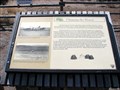
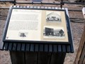
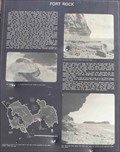
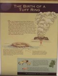 view gallery view galleryNW14.8 km | Fort Rock Signs in Oregon Historical Markers Four signs in shelter at Fort Rock posted by: Volcanoguy location: Oregon date approved: 06/29/2006 last visited: 09/18/2009 |
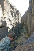
 view gallery view galleryNW14.8 km |  Fort Rock, Volcanic Tuff Ring Fort Rock, Volcanic Tuff Ring
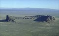
in Places of Geologic Significance Fort Rock is a volcanic tuff ring that towers above the desert floor at what was once the shore of an ancient lake bed. posted by: TheBeanTeam location: Oregon date approved: 04/30/2007 last visited: 11/26/2009 |
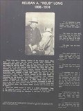 view gallery view galleryNW14.8 km | Reub Long in Oregon Historical Markers Reub Long Sign at Fort Rock posted by: Volcanoguy location: Oregon date approved: 06/28/2006 last visited: 09/18/2009 |
 view gallery view galleryNW15 km | Fort Rock, Oregon in Oregon Historical Markers Fort Rock Geology Sign posted by: Volcanoguy location: Oregon date approved: 06/28/2006 last visited: 08/25/2013 |
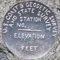
 view gallery view gallery W15.8 km W15.8 km
| USCGS D270, Oregon in U.S. Benchmarks U.S. Coast & Geodetic Survey and State Survey Benchmark D270 posted by: Volcanoguy location: Oregon date approved: 06/15/2007 last visited: 06/15/2007 |
 view gallery view gallery E16.4 km E16.4 km
| Crack in the Ground - Lake County, OR in Places of Geologic Significance Crack in the Ground is a tension fracture that formed when the Green Mountain lava flows draped over the upthrown side of a fault zone. Visitors can hike the length of the 2 mile long fissure. posted by: Hikenutty location: Oregon date approved: 09/09/2008 last visited: 10/01/2021 |
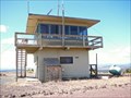 view gallery view gallery NE17.5 km NE17.5 km
|  Green Mountain Lookout Tower - Lake County, Oregon Green Mountain Lookout Tower - Lake County, Oregon
in Look-Out Towers The two story brick Green Mountain Lookout was built in 1963 and is operated by the BLM's Lakeview District in Lake County, Oregon. It has an elevation of 5,190 feet and is still in operation as a fire lookout. posted by: Hikenutty location: Oregon date approved: 09/05/2008 last visited: 05/30/2011 |
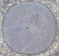 view gallery view galleryW18.2 km | OSHD Y562, Oregon in U.S. Benchmarks Oregon State Highway Department Benchmark Y562 posted by: Volcanoguy location: Oregon date approved: 06/13/2007 last visited: 06/13/2007 |
 view gallery view galleryNW18.2 km | USCGS L270, Oregon in U.S. Benchmarks U.S. Coast & Geodetic Survey and State Survey Benchmark L270 posted by: Volcanoguy location: Oregon date approved: 06/15/2007 last visited: 06/15/2007 |
 view gallery view galleryNW19.5 km | USCGS M270, Oregon in U.S. Benchmarks U.S. Coast & Geodetic Survey and State Survey Benchmark M270 posted by: Volcanoguy location: Oregon date approved: 06/15/2007 last visited: 06/15/2007 |
 view gallery view galleryE20.1 km |  Cone 3 of Four Craters Lava Field, Oregon Cone 3 of Four Craters Lava Field, Oregon
in Mountain Summits The third from the south cinder cone of the Four Craters Lava Field. posted by: Volcanoguy location: Oregon date approved: 12/07/2013 last visited: 11/23/2013 |
|