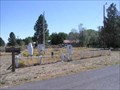
 view gallery view gallery W6.1 km W6.1 km
|   Silver Lake Cemetery, OR, USA Silver Lake Cemetery, OR, USA
in Worldwide Cemeteries Historic Silver Lake cemetery. posted by:  Volcanoguy Volcanoguy location: Oregon date approved: 09/30/2007 last visited: 10/24/2014 |
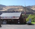
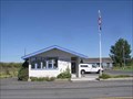 view gallery view galleryW7.1 km |  Silver Lake, OR, 97638 Silver Lake, OR, 97638
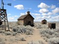
in U.S. Post Offices The Silver Lake, OR Post Office. posted by: Volcanoguy location: Oregon date approved: 09/28/2007 last visited: 08/01/2019 |
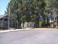
 view gallery view galleryW8.2 km |  Silver Lake USDA FS WS - Oregon Silver Lake USDA FS WS - Oregon
in Weather Stations USDA FS Weather Station at Silver Lake Ranger Station. posted by: Volcanoguy location: Oregon date approved: 09/30/2007 last visited: 10/24/2014 |
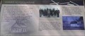
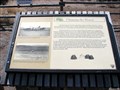
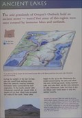 view gallery view galleryW8.2 km |  Ancient Lakes Ancient Lakes
in Oregon Historical Markers Two of the four signs at this kiosk at the Silver Lake Ranger Station. posted by: Volcanoguy location: Oregon date approved: 09/29/2007 last visited: 09/30/2007 |
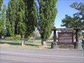
 view gallery view galleryW8.2 km |  Outback Scenic Byway - Silver Lake Interpretive Site Outback Scenic Byway - Silver Lake Interpretive Site
in National Scenic Byways Outback Scenic Byway - Silver Lake Interpretive Site posted by: Volcanoguy location: Oregon date approved: 05/24/2008 last visited: 10/24/2014 |
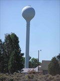 view gallery view galleryW8.2 km |  Silver Lake Water Tower - Oregon Silver Lake Water Tower - Oregon
in Water Towers Steel water tower at Silver Lake Ranger District Office Compound. posted by: Volcanoguy location: Oregon date approved: 09/29/2007 last visited: 10/24/2014 |
 view gallery view gallery SE16.4 km SE16.4 km
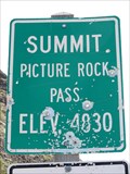
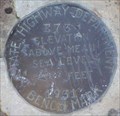
|  Picture Rock Pass - 4830' Picture Rock Pass - 4830'
in Elevation Signs Highway 31 between Silver Lake and Summer Lake. posted by: WR7X location: Oregon date approved: 05/25/2013 last visited: never |
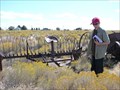
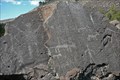 view gallery view gallerySE16.4 km | Picture Rock - Outback Scenic Byway - Oregon in National Scenic Byways Picture Rock Pass is located along Central Oregon's "Outback" and is named for the petroglyphs that can be found on the volcanic rocks that are within walking distance of the road. posted by:  Hikenutty Hikenutty location: Oregon date approved: 09/08/2008 last visited: 09/30/2012 |
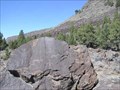 view gallery view gallerySE16.4 km |  Picture Rock Pass Petroglyphs Site Picture Rock Pass Petroglyphs Site
in U.S. National Register of Historic Places Petroglyph site at Picture Rock Pass on Ore. Hwy. 31 posted by: Volcanoguy location: Oregon date approved: 11/13/2007 last visited: 11/13/2007 |
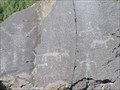 view gallery view gallerySE16.4 km |  Picture Rock Pass Petroglyphs, OR Picture Rock Pass Petroglyphs, OR
in Pictographs Petroglyphs at Picture Rock Pass on Ore. Hwy. 31 posted by: Volcanoguy location: Oregon date approved: 10/01/2007 last visited: 10/10/2014 |
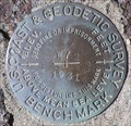
 view gallery view gallerySE16.4 km |  PB0590 - OSHD E73, OR PB0590 - OSHD E73, OR
in U.S. Benchmarks Oregon State Highway Department bench mark E73. posted by: Volcanoguy location: Oregon date approved: 09/30/2007 last visited: 09/30/2007 |
 view gallery view gallerySE20.8 km | PB0599 - USCGS W72, OR in U.S. Benchmarks U.S. Coast & Geodetic Survey bench mark W72. posted by: Volcanoguy location: Oregon date approved: 09/30/2007 last visited: 09/30/2007 |
 view gallery view gallerySE23.7 km | Summer Lake, OR, 97640 in U.S. Post Offices The Summer Lake, OR Post Office. posted by: Volcanoguy location: Oregon date approved: 09/29/2007 last visited: 09/29/2007 |
 view gallery view gallerySE23.7 km |  Summer Lake Rest Area, Oregon Summer Lake Rest Area, Oregon
in Highway Rest Areas The Summer Lake Rest Area on Ore. Hwy. 31. posted by: Volcanoguy location: Oregon date approved: 10/01/2007 last visited: 10/01/2007 |
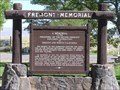 view gallery view gallerySE23.7 km | Fremont Memorial in Oregon Historical Markers The Fremont Memorial at Summer Lake posted by: Volcanoguy location: Oregon date approved: 10/01/2007 last visited: 10/01/2007 |
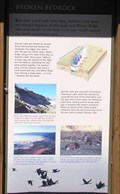 view gallery view gallerySE23.7 km | Broken Bedrock in Oregon Historical Markers Two of the four signs at this kiosk at the Summer Lake Rest Area. posted by: Volcanoguy location: Oregon date approved: 10/01/2007 last visited: 10/01/2007 |
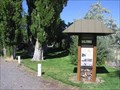 view gallery view gallerySE23.7 km | Outback Scenic Byway - Summer Lake Interpretive Site in National Scenic Byways Scenic Byway Interpretive Kiosk at the Summer Lake Rest Area. posted by: Volcanoguy location: Oregon date approved: 05/25/2008 last visited: 05/25/2008 |
 view gallery view gallerySE24.8 km | Outback Scenic Byway - Jack Lake Interpretive Site in National Scenic Byways Scenic Byway Interpretive Site at the Jack Lake. posted by: Volcanoguy location: Oregon date approved: 05/25/2008 last visited: 05/25/2008 |
 view gallery view gallerySE24.8 km | Harris Schoolhouse in Oregon Historical Markers Two of the six signs at this location. posted by: Volcanoguy location: Oregon date approved: 10/01/2007 last visited: 10/01/2007 |
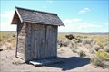 view gallery view gallery N25.4 km N25.4 km
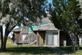
|  Fort Rock Homestead Village Museum 3-holer; Fort Rock, OR Fort Rock Homestead Village Museum 3-holer; Fort Rock, OR
in Outhouses This 3-holer can be found at the wonderful little history museum, Homestead Village Museum, in Fort Rock, Oregon. posted by: Hikenutty location: Oregon date approved: 09/08/2008 last visited: never |
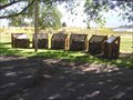
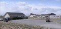
 view gallery view galleryN25.4 km |  Fort Rock Hay Rake and Misc. Equipment - Fort Rock, OR Fort Rock Hay Rake and Misc. Equipment - Fort Rock, OR
in Old Agricultural Equipment At the Fort Rock Homestead Museum there is an assortment of old farming equipment lying around to explore, including this hay rake behind the old church building. posted by: Hikenutty location: Oregon date approved: 09/22/2008 last visited: never |
 view gallery view gallery NE25.4 km NE25.4 km
|  Christmas Valley Geodesic Home - Christmas Valley, OR Christmas Valley Geodesic Home - Christmas Valley, OR
in Geodesic Domes This geodesic home can be found in the extremely rural high desert area of Central Oregon in the tiny town of Christmas Valley. Find it near the intersection of BLM road 6109D and 5-14. Please respect private property and stay on the road. posted by: Hikenutty location: Oregon date approved: 09/08/2008 last visited: never |
 view gallery view galleryN25.4 km | Fort Rock, OR. 97735 in U.S. Post Offices The Fort Rock, OR Post Office. posted by: Volcanoguy location: Oregon date approved: 04/18/2008 last visited: 04/18/2008 |
 view gallery view galleryN25.6 km | Claiming the Desert in Oregon Historical Markers Historical marker located outside the Fort Rock Village Historical Homestead Museum. posted by: TheBeanTeam location: Oregon date approved: 05/08/2007 last visited: 06/06/2007 |
 view gallery view galleryN25.6 km |  Fort Rock Homestead Village Fort Rock Homestead Village
in History Museums A desert museum honoring the pioneering spirit of homesteaders to the Fort Rock and surrounding areas. posted by: TheBeanTeam location: Oregon date approved: 06/18/2007 last visited: 02/03/2009 |
|