 view gallery view gallery SE0.2 km SE0.2 km
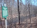
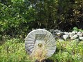
|   Piscataquog River Mill Sites Piscataquog River Mill Sites
in New Hampshire Historical Markers Piscataquog River Mill Sites posted by:  silverquill silverquill location: New Hampshire date approved: 03/21/2006 last visited: 07/06/2013 |
 view gallery view gallery E0.2 km E0.2 km
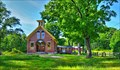
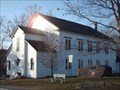
|  North Weare Schoolhouse - Weare NH North Weare Schoolhouse - Weare NH
in U.S. National Register of Historic Places Built in 1856, it was the best school in Weare during its heyday. posted by:  nomadwillie nomadwillie location: New Hampshire date approved: 12/18/2013 last visited: never |
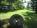
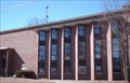
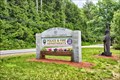 view gallery view gallerySE1.3 km |  Police and Fire Department - Weare, NH Police and Fire Department - Weare, NH
in Police Stations Locate on RT 114 at the intersection with Center Rd posted by: nomadwillie location: New Hampshire date approved: 04/14/2017 last visited: never |
 view gallery view gallery W1.9 km W1.9 km
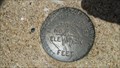
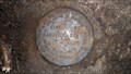
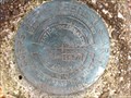
|  G 23 RESET 1939 (USC&GS&SS, Weare, NH) G 23 RESET 1939 (USC&GS&SS, Weare, NH)
in U.S. Benchmarks A USC&GS&SS standard disk, located in Weare, NH, at Horace Lake (Weare Reservoir).
The NHDOT ID# is 471-0460. posted by: NH2beers location: New Hampshire date approved: 07/24/2012 last visited: never |
 view gallery view gallerySE5.3 km | K 7 1925 RESET 1967 (USDI, Weare, NH) in U.S. Benchmarks A USDI standard survey mark, located in Weare, NH.
The NHDOT ID# is 471-0050. posted by: NH2beers location: New Hampshire date approved: 07/24/2012 last visited: never |
 view gallery view gallery NE6.1 km NE6.1 km
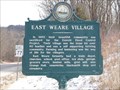
| East Weare Village in New Hampshire Historical Markers Marker dedicated to the memory of the thriving village of East Weare. The village became a ghost town in 1960 because of a federal flood control project. posted by: cache_test_dummies location: New Hampshire date approved: 03/03/2006 last visited: 07/03/2017 |
 view gallery view gallery S6.1 km S6.1 km
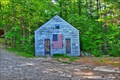
|  Friends School House - Weare NH Friends School House - Weare NH
in One-Room Schoolhouses Located on Deering Center Rd almost to the intersection with Jewett Rd posted by: nomadwillie location: New Hampshire date approved: 12/19/2013 last visited: never |
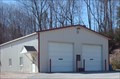 view gallery view gallerySE7.1 km |  Weare Fire Department Weare Fire Department
in Firehouses This is an unmarked fire station for the fire department for the small, rural town of Weare, New Hampshire. posted by: silverquill location: New Hampshire date approved: 03/10/2008 last visited: never |
 view gallery view galleryS7.2 km | Site of First Public School in Weare in New Hampshire Historical Markers A cool stone marker for the site of first Public School in Weare posted by: New England n00b location: New Hampshire date approved: 09/18/2006 last visited: 10/20/2009 |
 view gallery view galleryS7.4 km | Site of First Church in Weare in New Hampshire Historical Markers A cool marker denoting the site of the first church in Weare, NH. posted by: New England n00b location: New Hampshire date approved: 09/18/2006 last visited: 10/20/2009 |
 view gallery view galleryNE7.6 km | H-35 in U.S. Benchmarks A U.S. Army Corps of Engineers survey mark on the west side of Sugar Hill Road in Hopkinton, New Hampshire. posted by: Jay-7 location: New Hampshire date approved: 05/06/2013 last visited: never |
 view gallery view gallery N7.6 km N7.6 km
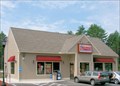
|  Dunkin Donuts - Henniker, NH Dunkin Donuts - Henniker, NH
in Dunkin Donuts' This Dunkin Donuts is located east of Henniker, New Hampshire, on busy route 9 and 202, at the site of the former Golden Pineapple gift store, a familiar local landmark. Free Wi-Fi is available, when it's working, outside seating, and a drive-thru. posted by: silverquill location: New Hampshire date approved: 09/10/2009 last visited: never |
 view gallery view galleryN7.6 km |  Dunkin Donuts Free Wi-Fi - Henniker, NH Dunkin Donuts Free Wi-Fi - Henniker, NH
in Wi-Fi Hotspots This Dunkin Donuts has free wi-fi -- when it's working, anyway. Located at the junction of Rt. 9 and 127 east of Henniker, New Hampshire at the site of the former Golden Pineapple gift shop, a familiar local landmark. posted by: silverquill location: New Hampshire date approved: 09/12/2009 last visited: never |
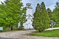 view gallery view gallery SW8.7 km SW8.7 km
|  Deering Community Church - Deering NH Deering Community Church - Deering NH
in This Old Church Built in 1829, however the congregation was formed in 1789. posted by: nomadwillie location: New Hampshire date approved: 05/29/2014 last visited: never |
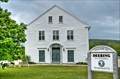 view gallery view gallerySW8.7 km |  Deering, NH Deering, NH
in City and Town Halls The Town Hall was built in 1788 as the first meeting house and served as both a church and a civic center. posted by: nomadwillie location: New Hampshire date approved: 05/29/2014 last visited: never |
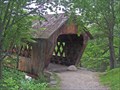
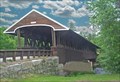 view gallery view galleryN9.2 km |  Rowell's Bridge Rowell's Bridge
in Covered Bridges There are several bridges in this area to visit on a nice outing day. posted by: CoveredBridgeGuy location: New Hampshire date approved: 12/09/2006 last visited: never |
 view gallery view galleryN9.2 km | Rowell's Covered Bridge - West Hopkinton NH in U.S. National Register of Historic Places The bridge was built by Horace Childs of Henniker with the help of his brothers Enoch and Warren. The Rowell's Bridge is listed on the National Register of Historic Places. posted by: nomadwillie location: New Hampshire date approved: 12/12/2008 last visited: 05/26/2014 |
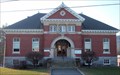
 view gallery view gallery NW9.2 km NW9.2 km
| Henniker Town Hall - Henniker, NH in U.S. National Register of Historic Places Built in 1787, Henniker's Town Hall also served as the church meetinghouse after the original 1770 log building had burned. posted by: silverquill location: New Hampshire date approved: 06/20/2007 last visited: 07/06/2013 |
 view gallery view galleryNW9.2 km | Henniker, NH in City and Town Halls Built in 1787, Henniker's Town Hall also served as the church meetinghouse after the original 1770 log building had burned. posted by: silverquill location: New Hampshire date approved: 06/20/2007 last visited: never |
 view gallery view galleryNW9.3 km |  H. Raymond Danforth Library of New England College - Henniker, NH H. Raymond Danforth Library of New England College - Henniker, NH
in Libraries This is the library on the campus of New England College in Henniker, NH. The Danforth Library provides materials for both classroom activities and outside interests. These materials include books, periodicals, records, CD's, videos, and more. posted by: silverquill location: New Hampshire date approved: 05/06/2007 last visited: never |
 view gallery view galleryNW9.5 km |  Edna Dean Proctor Bridge - Henniker NH Edna Dean Proctor Bridge - Henniker NH
in Stone Bridges The Edna Dean Proctor bridge was built in 1939 posted by: nomadwillie location: New Hampshire date approved: 12/19/2013 last visited: never |
 view gallery view galleryNW9.5 km |  Edna Dean Proctor Bridge - Henniker NH Edna Dean Proctor Bridge - Henniker NH
in Arch Bridges The Edna Dean Proctor bridge was built in 1939 posted by: nomadwillie location: New Hampshire date approved: 12/19/2013 last visited: never |
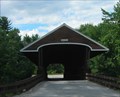
 view gallery view galleryNW9.5 km | New England College Bridge in Covered Bridges This one is on the New England College campus and was built for use of students as a shortcut to the other side of the campus. posted by: CoveredBridgeGuy location: New Hampshire date approved: 12/17/2006 last visited: never |
 view gallery view galleryNW9.7 km | Tucker Free Library - Henniker, NH in Libraries The Tucker Free Library is housed in this beautiful building build in 1903. The library offers over 30,000 volumes to the residents of Henniker, New Hampshire. New England College is also located in this small New Hampshire town. posted by: silverquill location: New Hampshire date approved: 01/16/2008 last visited: never |
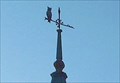 view gallery view galleryNW9.7 km |  Owl on Coswell School - Henniker, NH Owl on Coswell School - Henniker, NH
in Unique Weathervanes This weather vane depicting an owl is atop the Coswell Memorial School in the town of Henniker, New Hampshire. posted by: silverquill location: New Hampshire date approved: 10/10/2007 last visited: never |
|