 view gallery view gallery S0.2 km S0.2 km
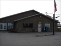
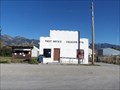
|   Etna , Wyoming 83118 Etna , Wyoming 83118
in U.S. Post Offices The little town of Etna has a Post Office at these coordinates. posted by:  JacobBarlow JacobBarlow location: Wyoming date approved: 09/13/2007 last visited: 09/13/2007 |
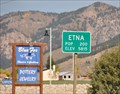
 view gallery view galleryS0.2 km |  Star Valley Community Complex Time & Temperature Star Valley Community Complex Time & Temperature
in Time and Temperature Signs This Time and Temperature Sign is in front of the Star Valley Community Complex located at 107736 US Highway 89 in Thayne, Wyoming. posted by: brwhiz location: Wyoming date approved: 08/29/2013 last visited: 10/25/2022 |
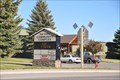
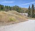
 view gallery view galleryS0.5 km |  The Baker Cabin The Baker Cabin
in D.U.P. Historic Markers This Historical Cabin and Marker is located on the west side of US Highway 89 between County Road 169 and Gravel Pit Road in Etna, Wyoming. posted by: brwhiz location: Wyoming date approved: 09/26/2012 last visited: never |
 view gallery view galleryS0.5 km |  The Baker Cabin The Baker Cabin
in Wyoming Historical Markers This Historical Cabin and Marker is located on the west side of US Highway 89 between County Road 169 and Gravel Pit Road in Etna, Wyoming. posted by: brwhiz location: Wyoming date approved: 09/26/2012 last visited: 10/25/2022 |
 view gallery view galleryS0.5 km |  First House in Star Valley with Shingled Roof and Wooden Floors First House in Star Valley with Shingled Roof and Wooden Floors
in First of its Kind The Baker Cabin was the first residence in Star Valley to have a shingled roof and wooden floors. posted by: brwhiz location: Wyoming date approved: 09/26/2012 last visited: never |
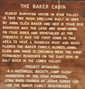 view gallery view galleryS0.5 km | First Permanent Residents on East Side of Salt River in Lower Star Valley in First of its Kind The Baker family were the first permanent residents on the east side of the Salt River in the lower Star Valley. posted by: brwhiz location: Wyoming date approved: 09/26/2012 last visited: never |
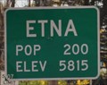 view gallery view gallery N0.5 km N0.5 km
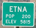
|  Etna, Wyoming - Northern Approach Etna, Wyoming - Northern Approach
in Population Signs Etna has an elevation almost 30 times its population! posted by: brwhiz location: Wyoming date approved: 03/22/2011 last visited: 05/28/2012 |
 view gallery view galleryN0.5 km |  Etna, Wyoming - Northern Approach Etna, Wyoming - Northern Approach
in Elevation Signs This sign pronounces the population and elevation of Etna as you enter town from the north on US Highway 89. posted by: brwhiz location: Wyoming date approved: 03/18/2011 last visited: 05/28/2012 |
 view gallery view galleryS0.8 km | Etna Wyoming - Southern Approach in Elevation Signs This sign pronounces the population and elevation of Etna as you enter town from the south on US Highway 89. posted by: brwhiz location: Wyoming date approved: 03/18/2011 last visited: never |
 view gallery view galleryS0.8 km | Etna Wyoming - Southern Approach in Population Signs Etna has an elevation almost 30 times its population! posted by: brwhiz location: Wyoming date approved: 03/19/2011 last visited: never |
 view gallery view galleryS0.8 km |  Etna, Wyoming Etna, Wyoming
in Wikipedia Entries Etna, Wyoming is a town where there isn't much evidence of its existence as an "urban" entity. posted by: brwhiz location: Wyoming date approved: 03/25/2011 last visited: never |
 view gallery view gallery SW4.8 km SW4.8 km
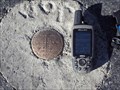
|  Idaho / Wyoming Border Benchmark - #139 Idaho / Wyoming Border Benchmark - #139
in U.S. Benchmarks Idaho / Wyoming Border Benchmark - Number 139 - Freedom, Wyoming, USA posted by: Chooch72 location: Wyoming date approved: 10/05/2007 last visited: never |
 view gallery view gallerySW5 km |  Idaho / Wyoming Border - Idaho 34 W Idaho / Wyoming Border - Idaho 34 W
in Border Crossings Wyoming / Idaho Border - Idaho Border on Idaho 34 Westbound posted by: Chooch72 location: Idaho date approved: 10/09/2007 last visited: 08/02/2012 |
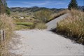
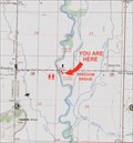 view gallery view galleryS6 km |  Salt River Public Access Area Salt River Public Access Area
in 'You Are Here' Maps You Are Here at the Freedom Bridge public access area on the Salt River on Wyoming Highway 239 about 0.6 mile east of Freedom, Wyoming. posted by: brwhiz location: Wyoming date approved: 08/29/2013 last visited: never |
 view gallery view galleryS6.1 km | Freedom, Wyoming ~ Population 100 in Population Signs This combination Elevation/Population sign is on the north side of Wyoming Highway 239 at the eastern town limits of Freedom, Wyoming. posted by: brwhiz location: Wyoming date approved: 07/28/2013 last visited: never |
 view gallery view galleryS6.1 km | Freedom, Wyoming ~ Elevation 5900 Feet in Elevation Signs This combination Elevation/Population sign is on the north side of Wyoming Highway 239 at the eastern town limits of Freedom, Wyoming. posted by: brwhiz location: Wyoming date approved: 07/25/2013 last visited: never |
 view gallery view gallerySW6.3 km | Freedom, Wyoming - 83120 in U.S. Post Offices Freedom, Wyoming Post Office - Zip 83120 posted by: Chooch72 location: Wyoming date approved: 09/30/2007 last visited: never |
 view gallery view galleryN9.7 km |  Salt River Hydroelectric Powerplant - Canal - Etna, Wyoming Salt River Hydroelectric Powerplant - Canal - Etna, Wyoming
in NRHP Historic Districts - Contributing Buildings The Canal provided the pathway from the Diversion Dam (demolished) to the Powerplant. posted by: brwhiz location: Wyoming date approved: 01/10/2011 last visited: 10/25/2022 |
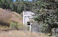
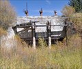 view gallery view galleryN9.8 km | Salt River Hydroelectric Powerplant - Inlet Structure - Etna, Wyoming in NRHP Historic Districts - Contributing Buildings The inlet structure, built in 1938 of cast-in-place concrete, controlled the flow of water to the turbines. posted by: brwhiz location: Wyoming date approved: 01/10/2011 last visited: 07/23/2012 |
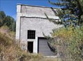 view gallery view galleryN9.8 km | Salt River Hydroelectric Powerplant - Powerplant Building - Etna, Wyoming in NRHP Historic Districts - Contributing Buildings The Powerplant Building, built in 1938 of concrete block, is the central structure of the power generating complex. posted by: brwhiz location: Wyoming date approved: 01/10/2011 last visited: 07/23/2012 |
 view gallery view galleryN9.8 km |  Salt River Hydroelectric Powerplant ~ Etna, Wyoming Salt River Hydroelectric Powerplant ~ Etna, Wyoming
in U.S. National Register of Historic Places The Salt River Hydroelectric Powerplant is an abandoned generating project from the 1930's. It was placed on the National Register of Historic Places on December 2, 1993. posted by: brwhiz location: Wyoming date approved: 01/10/2011 last visited: 07/23/2012 |
 view gallery view galleryN9.8 km | Salt River Hydroelectric Powerplant - Overflow Spillway - Etna, Wyoming in NRHP Historic Districts - Contributing Buildings The Overflow Spillway provided an escape route for excess water coming down the canal and not able to enter the Inlet Structure. posted by: brwhiz location: Wyoming date approved: 01/10/2011 last visited: 07/23/2012 |
 view gallery view galleryS11.3 km | Thayne, Wyoming in Elevation Signs This combination sign announces population and elevation of Thayne as you enter from the north on US Highway 89. posted by: brwhiz location: Wyoming date approved: 03/18/2011 last visited: 04/05/2015 |
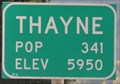 view gallery view galleryS11.3 km | Thayne, Wyoming in Population Signs Thayne is another western Wyoming town where the elevation far exceeds the population. posted by: brwhiz location: Wyoming date approved: 03/22/2011 last visited: 05/28/2016 |
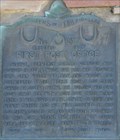 view gallery view galleryS12.4 km | First Post Office ~ 277 in D.U.P. Historic Markers The first official post office in Starr Valley Wyoming was established in 1891 in the town of Glencoe (now known as Thayne). posted by: brwhiz location: Wyoming date approved: 03/20/2011 last visited: never |
|