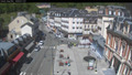
 view gallery view gallery SW4.8 km SW4.8 km
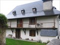
|   La Condorinette - Arrens-Marsous (Haute Pyrénées), France La Condorinette - Arrens-Marsous (Haute Pyrénées), France
in Bed and Breakfast [FR] La maison d’hôtes de caractère typiquement bigourdan a été construite en 1623. [EN] The B&B is a traditional Pyrenean cottage that was built in 1623. posted by:  RakeInTheCache RakeInTheCache location: Occitanie, France date approved: 05/22/2012 last visited: never |
 view gallery view gallery E4.8 km E4.8 km
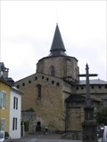
|  Abbatiale de Saint Savin (Haute Pyrénées), France Abbatiale de Saint Savin (Haute Pyrénées), France
in Medieval Churches [FR] L'abbatiale de Saint Savin est située quelques kilomètres au dessus d'Argelès-Gazost. [EN] They abbey church of Saint Savin is situation a few kilometers above Argelès-Gazost. posted by: RakeInTheCache location: Occitanie, France date approved: 05/21/2012 last visited: never |
 view gallery view gallery NE7.9 km NE7.9 km
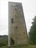
|  Tour d'Agos-Vidalos. France Tour d'Agos-Vidalos. France
in Look-Out Towers Tour d'Agos-Vidalos posted by: lulu_et_compagnie location: Occitanie, France date approved: 10/03/2015 last visited: 07/28/2014 |
 view gallery view gallery W7.9 km W7.9 km
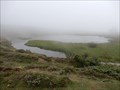
|  Lac de Soum - Col du Soulor - Arbeost, Occitanie, France Lac de Soum - Col du Soulor - Arbeost, Occitanie, France
in Natural Lakes The lake is located a hundred meters from the Col du Soulor.
Le lac est situé a une centaine de metres du Col du Soulor. posted by: sara et gege location: Occitanie, France date approved: 09/17/2019 last visited: 12/30/2019 |
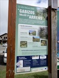
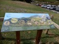 view gallery view galleryW9.2 km |  Col du Soulor Faune, Arbeost, Occitanie, France Col du Soulor Faune, Arbeost, Occitanie, France
in Flora and Fauna Information Signs The panels are at the neck of Soulor.
Les panneaux sont au col du Soulor. posted by: sara et gege location: Occitanie, France date approved: 09/16/2019 last visited: 12/29/2019 |
 view gallery view galleryW9.3 km | Col du Soulor Migrer, Arbeost, Occitanie, France in Flora and Fauna Information Signs the panels are at the neck of Soulor.
les panneaux sont au col du Soulor. posted by: sara et gege location: Occitanie, France date approved: 09/16/2019 last visited: 12/29/2019 |
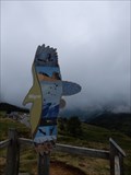
 view gallery view galleryW9.3 km |  Tyrolienne Deval Cable Col du Soulor - Arbeost, Occitanie, France Tyrolienne Deval Cable Col du Soulor - Arbeost, Occitanie, France
in Zip-line the zipline is at the neck of Soulor.
La tyrolienne est au col du Soulor. posted by: sara et gege location: Occitanie, France date approved: 09/19/2019 last visited: 12/29/2019 |
 view gallery view galleryW9.3 km | Col du Soulor Faune Migration, Arbeost, Occitanie, France in Flora and Fauna Information Signs The panels are at the neck of Soulor.
Les panneaux sont au col du Soulor. posted by: sara et gege location: Occitanie, France date approved: 09/16/2019 last visited: 12/29/2019 |
 view gallery view galleryW9.3 km | Col du Soulor site Natura 2000 - Arbeost, Occitanie, France in Flora and Fauna Information Signs the panels are at the neck of Soulor.
les panneaux sont au col du Soulor. posted by: sara et gege location: Occitanie, France date approved: 09/16/2019 last visited: 12/29/2019 |
 view gallery view galleryW9.3 km |  Col du Soulor - Arbeost, Occitanie, France Col du Soulor - Arbeost, Occitanie, France
in Wikipedia Entries the panels are at the neck of Soulor.
les panneaux sont au col du Soulor. posted by: sara et gege location: Occitanie, France date approved: 09/17/2019 last visited: 12/29/2019 |
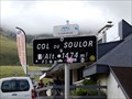 view gallery view galleryW9.3 km |  1474 m - col du Soulor - Arrens Marsous, Occitanie, France 1474 m - col du Soulor - Arrens Marsous, Occitanie, France
in Elevation Signs le col du Soulor posted by: sara et gege location: Occitanie, France date approved: 08/22/2019 last visited: 11/28/2019 |
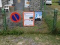
 view gallery view galleryW9.8 km |  VOUS ÊTES ICI - Aire de Pique-nique, FERRIÈRES, France VOUS ÊTES ICI - Aire de Pique-nique, FERRIÈRES, France
in 'You Are Here' Maps You are at a hight of 550 m. posted by: GEOrgCACHING location: Occitanie, France date approved: 06/06/2024 last visited: never |
 view gallery view galleryW9.8 km |  LA BOITE À LIRE - FERRIÈRES, FRANCE LA BOITE À LIRE - FERRIÈRES, FRANCE
in Free Community Book Exchanges Free library with toilet. posted by: GEOrgCACHING location: Occitanie, France date approved: 06/06/2024 last visited: never |
 view gallery view galleryW10 km | VOUS ÊTES ICI - PANORAMA DU CHÊNE, Ferrières, France in 'You Are Here' Maps You are near the old mine … posted by: GEOrgCACHING location: Nouvelle-Aquitaine, France date approved: 06/03/2024 last visited: never |
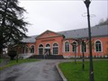 view gallery view gallery S10.9 km S10.9 km
|  Les Bains du Rocher - Cauterets (Hautes-Pyrénées), France Les Bains du Rocher - Cauterets (Hautes-Pyrénées), France
in Spas, Hammams, Mineral Baths and Saunas [FR] Les Bains du Rocher vous attendent à Cauterets dans un cadre grandiose et parfaitement intégré à la Nature. [EN] the Bains de Rocher spa proposes relaxation and wellbeing in an original and refined setting. posted by: RakeInTheCache location: Occitanie, France date approved: 05/21/2012 last visited: never |
 view gallery view galleryS10.9 km |  Webcam Cauterets (65) Webcam Cauterets (65)
in Web Cameras Webcam de Cauterets - Village posted by: JulieDavy location: Occitanie, France date approved: 05/31/2019 last visited: never |
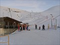 view gallery view galleryE11.7 km |  Parc de loisirs - Hautacam,fr Parc de loisirs - Hautacam,fr
in Roller Coasters Leisure park Hautacam (the Pyrenees ski resort)
Parc de loisirs de Hautacam (station de ski des Pyrennees) posted by: sara et gege location: Occitanie, France date approved: 10/20/2015 last visited: 10/20/2015 |
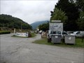
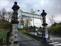
 view gallery view gallery N13.4 km N13.4 km
|  borne separation departement - Betharram, Nouvelle Aquitaine, France borne separation departement - Betharram, Nouvelle Aquitaine, France
in European Historic Survey Stones, Monuments and Benchmarks To see when visiting the caves.
A voir lors de la visite des grottes. posted by: sara et gege location: Nouvelle-Aquitaine, France date approved: 10/06/2019 last visited: 01/07/2020 |
 view gallery view galleryN13.4 km |  Kayak Ohlala eau vive - Betharram, Nouvelle Aquitaine, France Kayak Ohlala eau vive - Betharram, Nouvelle Aquitaine, France
in Canoe/Kayak Trips on the banks of the Gave de Pau at Lestelle Betharram on the road to Lourdes
sur les bords du Gave de Pau à Lestelle Betharram sur la route de Lourdes posted by: sara et gege location: Nouvelle-Aquitaine, France date approved: 10/07/2019 last visited: 01/07/2020 |
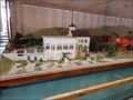 view gallery view galleryN13.5 km |  Maquette grottes Betharram - Lestelle Betharram, Nouvelle Aquitaine, France Maquette grottes Betharram - Lestelle Betharram, Nouvelle Aquitaine, France
in 3D Map Models of Our World and Beyond the caves were discovered in 1913.
les grottes ont été découverte en 1913. posted by: sara et gege location: Nouvelle-Aquitaine, France date approved: 10/07/2019 last visited: 01/07/2020 |
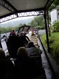 view gallery view galleryN13.5 km |  Petit train grotte Betharram - Betharam, Nouvelle Aquitaine, France Petit train grotte Betharram - Betharam, Nouvelle Aquitaine, France
in Miniature Railroads the caves were discovered in 1913.
les grottes ont été découverte en 1913. posted by: sara et gege location: Nouvelle-Aquitaine, France date approved: 10/12/2019 last visited: 01/07/2020 |
 view gallery view galleryN13.5 km |  Grottes de Betharram - Lestelle Betharram, Nouvelle Aquitaine, France Grottes de Betharram - Lestelle Betharram, Nouvelle Aquitaine, France
in Official Local Tourism Attractions the caves were discovered in 1913.
les grottes ont été découverte en 1913. posted by: sara et gege location: Nouvelle-Aquitaine, France date approved: 10/06/2019 last visited: 01/07/2020 |
 view gallery view galleryN13.5 km | ") Grottes de Betharram - Lestelle Betharram, Nouvelle Aquitaine, France Grottes de Betharram - Lestelle Betharram, Nouvelle Aquitaine, France
in Cave Entrances (Natural) the caves were discovered in 1913.
les grottes ont été découverte en 1913. posted by: sara et gege location: Nouvelle-Aquitaine, France date approved: 10/07/2019 last visited: 01/07/2020 |
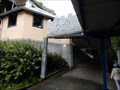
 view gallery view galleryNE14 km |  L'entrée du funiculaire du pic de Jer - Lourdes - France L'entrée du funiculaire du pic de Jer - Lourdes - France
in Freestanding Arches Imposante entrée du début de XXème siècle constituée de deux poteaux en pierre, reliés par une arche en fer forgé.
Imposing entrance of the early twentieth century consists of two stone posts, connected by a wrought iron arch. posted by: Alfouine location: Occitanie, France date approved: 04/29/2018 last visited: 10/21/2018 |
 view gallery view galleryNE14 km | Musée de la connaissance du risque sismique - Lourdes - France in Official Local Tourism Attractions Unique en France et en Europe, la Maison de la connaissance du risque sismique a été inaugurée en mars 2013.
Unique in France and in Europe, the House of knowledge of seismic risk was inaugurated in March 2013. posted by: Alfouine location: Occitanie, France date approved: 04/29/2018 last visited: 02/22/2019 |
|