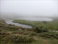
 view gallery view gallery NW1.3 km NW1.3 km
|   Lac de Soum - Col du Soulor - Arbeost, Occitanie, France Lac de Soum - Col du Soulor - Arbeost, Occitanie, France
in Natural Lakes The lake is located a hundred meters from the Col du Soulor.
Le lac est situé a une centaine de metres du Col du Soulor. posted by:  sara et gege sara et gege location: Occitanie, France date approved: 09/17/2019 last visited: 12/30/2019 |
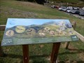 view gallery view gallery W2.3 km W2.3 km
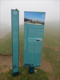
|  Col du Soulor Faune, Arbeost, Occitanie, France Col du Soulor Faune, Arbeost, Occitanie, France
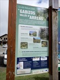
in Flora and Fauna Information Signs The panels are at the neck of Soulor.
Les panneaux sont au col du Soulor. posted by: sara et gege location: Occitanie, France date approved: 09/16/2019 last visited: 12/29/2019 |
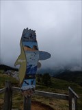 view gallery view galleryW2.3 km | Col du Soulor Migrer, Arbeost, Occitanie, France in Flora and Fauna Information Signs the panels are at the neck of Soulor.
les panneaux sont au col du Soulor. posted by: sara et gege location: Occitanie, France date approved: 09/16/2019 last visited: 12/29/2019 |
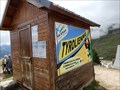 view gallery view galleryW2.3 km |  Tyrolienne Deval Cable Col du Soulor - Arbeost, Occitanie, France Tyrolienne Deval Cable Col du Soulor - Arbeost, Occitanie, France
in Zip-line the zipline is at the neck of Soulor.
La tyrolienne est au col du Soulor. posted by: sara et gege location: Occitanie, France date approved: 09/19/2019 last visited: 12/29/2019 |
 view gallery view galleryW2.4 km | Col du Soulor Faune Migration, Arbeost, Occitanie, France in Flora and Fauna Information Signs The panels are at the neck of Soulor.
Les panneaux sont au col du Soulor. posted by: sara et gege location: Occitanie, France date approved: 09/16/2019 last visited: 12/29/2019 |
 view gallery view galleryW2.4 km | Col du Soulor site Natura 2000 - Arbeost, Occitanie, France in Flora and Fauna Information Signs the panels are at the neck of Soulor.
les panneaux sont au col du Soulor. posted by: sara et gege location: Occitanie, France date approved: 09/16/2019 last visited: 12/29/2019 |
 view gallery view galleryW2.4 km |  Col du Soulor - Arbeost, Occitanie, France Col du Soulor - Arbeost, Occitanie, France
in Wikipedia Entries the panels are at the neck of Soulor.
les panneaux sont au col du Soulor. posted by: sara et gege location: Occitanie, France date approved: 09/17/2019 last visited: 12/29/2019 |
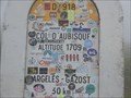
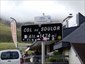 view gallery view galleryW2.4 km |  1474 m - col du Soulor - Arrens Marsous, Occitanie, France 1474 m - col du Soulor - Arrens Marsous, Occitanie, France
in Elevation Signs le col du Soulor posted by: sara et gege location: Occitanie, France date approved: 08/22/2019 last visited: 11/28/2019 |
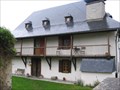 view gallery view gallery E2.6 km E2.6 km
|  La Condorinette - Arrens-Marsous (Haute Pyrénées), France La Condorinette - Arrens-Marsous (Haute Pyrénées), France
in Bed and Breakfast [FR] La maison d’hôtes de caractère typiquement bigourdan a été construite en 1623. [EN] The B&B is a traditional Pyrenean cottage that was built in 1623. posted by: RakeInTheCache location: Occitanie, France date approved: 05/22/2012 last visited: never |
 view gallery view galleryNW5.5 km |  VOUS ÊTES ICI - Aire de Pique-nique, FERRIÈRES, France VOUS ÊTES ICI - Aire de Pique-nique, FERRIÈRES, France
in 'You Are Here' Maps You are at a hight of 550 m. posted by: GEOrgCACHING location: Occitanie, France date approved: 06/06/2024 last visited: never |
 view gallery view galleryNW5.5 km |  LA BOITE À LIRE - FERRIÈRES, FRANCE LA BOITE À LIRE - FERRIÈRES, FRANCE
in Free Community Book Exchanges Free library with toilet. posted by: GEOrgCACHING location: Occitanie, France date approved: 06/06/2024 last visited: never |
 view gallery view galleryNW5.5 km | VOUS ÊTES ICI - PANORAMA DU CHÊNE, Ferrières, France in 'You Are Here' Maps You are near the old mine … posted by: GEOrgCACHING location: Nouvelle-Aquitaine, France date approved: 06/03/2024 last visited: never |
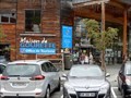
 view gallery view galleryW8 km |  Gourette - Aquitaine/Pyrénées-Atlantiques, France Gourette - Aquitaine/Pyrénées-Atlantiques, France
in Winter Sports Locations Station de ski Gourette posted by: pilouille location: Pays de la Loire, France date approved: 03/29/2015 last visited: 09/04/2021 |
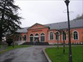
 view gallery view galleryW8.2 km |  Office de Tourisme Gourette - Eaux Bonnes, Nouvelle Aquitaine, France Office de Tourisme Gourette - Eaux Bonnes, Nouvelle Aquitaine, France
in Tourist Information Centers - Visitor Centers In the town center.
Dans le centre Ville. posted by: sara et gege location: Nouvelle-Aquitaine, France date approved: 09/19/2019 last visited: 12/31/2019 |
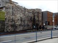 view gallery view galleryW8.2 km |  Mur escalade Gourette - Eaux Bonnes, Nouvelle Aquitaine, France Mur escalade Gourette - Eaux Bonnes, Nouvelle Aquitaine, France
in Artificial Climbing Walls In the town center
Dans le centre ville. posted by: sara et gege location: Nouvelle-Aquitaine, France date approved: 09/18/2019 last visited: 12/31/2019 |
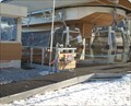 view gallery view galleryW8.2 km |  Télécabine du Bézou - Gourette, Aquitaine/Pyrénées-Atlantiques, France Télécabine du Bézou - Gourette, Aquitaine/Pyrénées-Atlantiques, France
in Aerial Lifts Télécabine du Bézou posted by: pilouille location: Nouvelle-Aquitaine, France date approved: 04/01/2015 last visited: 09/04/2021 |
 view gallery view galleryW8.7 km | ") Tour de France Col de l Aubisque - Beost, Nouvelle Aquitaine, France Tour de France Col de l Aubisque - Beost, Nouvelle Aquitaine, France
in Histoires de France (French historical markers) the sign is located at the neck of Aubisque.
le panneau est situé au col de l'Aubisque. posted by: sara et gege location: Occitanie, France date approved: 09/17/2019 last visited: 12/30/2019 |
 view gallery view galleryW8.7 km | Col de l Aubisque - Beost, Nouvelle Aquitaine, France in Wikipedia Entries another mythical pass from the Tour de France.
encore un col Mythique du Tour de France. posted by: sara et gege location: Nouvelle-Aquitaine, France date approved: 09/17/2019 last visited: 12/30/2019 |
 view gallery view galleryW8.7 km | 1709 m col de l Aubisque - Beost,Nouvelle Aquitaine, France in Elevation Signs le col de l'aubisque. posted by: sara et gege location: Nouvelle-Aquitaine, France date approved: 08/22/2019 last visited: 11/29/2019 |
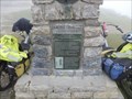 view gallery view galleryW8.7 km |  Andre Bach Col de l Aubisque - Beost, Nouvelle Aquitaine, France Andre Bach Col de l Aubisque - Beost, Nouvelle Aquitaine, France
in Citizen Memorials The stele is at the top u col de l'Aubisque.
La stele est au sommet u col de l'Aubisque. posted by: sara et gege location: Nouvelle-Aquitaine, France date approved: 09/17/2019 last visited: 12/31/2019 |
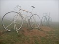 view gallery view galleryW8.7 km |  Velos Geants - Col de l Aubisque - Beost, Nouvelle Aquitaine, France Velos Geants - Col de l Aubisque - Beost, Nouvelle Aquitaine, France
in Figurative Public Sculpture In front of the Auberge du Col de l'Aubisque.
En face de l'auberge du col de l Aubisque. posted by: sara et gege location: Nouvelle-Aquitaine, France date approved: 09/22/2019 last visited: 12/31/2019 |
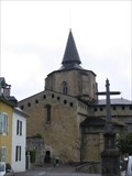 view gallery view galleryE11.7 km |  Abbatiale de Saint Savin (Haute Pyrénées), France Abbatiale de Saint Savin (Haute Pyrénées), France
in Medieval Churches [FR] L'abbatiale de Saint Savin est située quelques kilomètres au dessus d'Argelès-Gazost. [EN] They abbey church of Saint Savin is situation a few kilometers above Argelès-Gazost. posted by: RakeInTheCache location: Occitanie, France date approved: 05/21/2012 last visited: never |
 view gallery view gallery SE13 km SE13 km
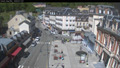
|  Webcam Cauterets (65) Webcam Cauterets (65)
in Web Cameras Webcam de Cauterets - Village posted by: JulieDavy location: Occitanie, France date approved: 05/31/2019 last visited: never |
 view gallery view gallerySE13 km |  Les Bains du Rocher - Cauterets (Hautes-Pyrénées), France Les Bains du Rocher - Cauterets (Hautes-Pyrénées), France
in Spas, Hammams, Mineral Baths and Saunas [FR] Les Bains du Rocher vous attendent à Cauterets dans un cadre grandiose et parfaitement intégré à la Nature. [EN] the Bains de Rocher spa proposes relaxation and wellbeing in an original and refined setting. posted by: RakeInTheCache location: Occitanie, France date approved: 05/21/2012 last visited: never |
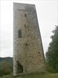 view gallery view gallery NE14.5 km NE14.5 km
|  Tour d'Agos-Vidalos. France Tour d'Agos-Vidalos. France
in Look-Out Towers Tour d'Agos-Vidalos posted by: lulu_et_compagnie location: Occitanie, France date approved: 10/03/2015 last visited: 07/28/2014 |
|