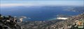
 view gallery view gallery SW8.7 km SW8.7 km
|   A Moa, Carnota (A Coruña) A Moa, Carnota (A Coruña)
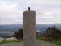
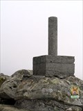
in Vértices Geodésicos Situado en lo más alto del monte Pindo, en una enorme roca granítica de forma ovalada con curiosas charcas en la piedra. posted by:  OGolpe OGolpe location: Spain date approved: 06/06/2007 last visited: 09/13/2008 |
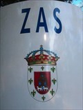 view gallery view gallery NE11.7 km NE11.7 km
|  Zas - Galicia, Spain Zas - Galicia, Spain
in Coats of Arms Zas is a municipality of northwestern Spain in the province of A Coruña in the autonomous community of Galicia. It belongs to the comarca of Tierra de Soneira. posted by:  razalas razalas location: Galicia, Spain date approved: 12/22/2020 last visited: 07/24/2023 |
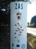 view gallery view galleryNE11.7 km |  Zas - Galicia, Spain Zas - Galicia, Spain
in 'Z' Welcome Signs Zas is a municipality of northwestern Spain in the province of A Coruña in the autonomous community of Galicia. It belongs to the comarca of Tierra de Soneira. posted by: razalas location: Galicia, Spain date approved: 10/13/2015 last visited: 07/24/2023 |
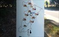 view gallery view galleryNE11.7 km |  Está Vc. Aqui - Zas - Galicia, Spain Está Vc. Aqui - Zas - Galicia, Spain
in 'You Are Here' Maps A Está Vc. Aqui (you are here) map at the entrance of Zas, that is a municipality of northwestern Spain in the province of A Coruña in the autonomous community of Galicia. It belongs to the comarca of Tierra de Soneira. posted by: razalas location: Galicia, Spain date approved: 12/22/2020 last visited: 07/24/2023 |
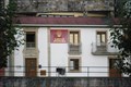 view gallery view gallery W13.2 km W13.2 km
|  Albergue Moreira - Cee, Spain Albergue Moreira - Cee, Spain
in Way of St. James This Pilgrims hostel is located on the left side of promenade in front of the beach in the city of Cee. posted by: razalas location: Galicia, Spain date approved: 09/30/2014 last visited: never |
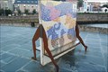 view gallery view galleryW13.2 km |  Cée pier bench - Cée, Spain Cée pier bench - Cée, Spain
in Artistic Seating This bench with two sides is situated at the end of the pier in the city of Cée. posted by: razalas location: Galicia, Spain date approved: 12/04/2014 last visited: never |
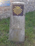
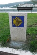 view gallery view galleryW13.2 km | Way Marker Paseo Maritimo (left side) - Cee, Spain in Way of St. James This Way Marker is located on the left side of promenade in front of the beach in the city of Cee. posted by: razalas location: Galicia, Spain date approved: 09/30/2014 last visited: never |
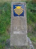
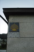 view gallery view galleryW13.4 km | Way Marker Paseo Maritimo (center) - Cee, Spain in Way of St. James This Way Marker is located on the center of the promenade right next to the beach in the city of Cee. posted by: razalas location: Galicia, Spain date approved: 09/30/2014 last visited: never |
 view gallery view gallery SE13.5 km SE13.5 km
| Tremuzo (Outes) in Vértices Geodésicos Situado en el extremo Sur del monte de Tremuzo, en su parte más alta.
Outes. A Coruña.
posted by: pertico location: Spain date approved: 01/26/2007 last visited: 09/15/2007 |
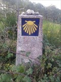
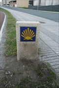 view gallery view galleryW13.5 km | Way Marker Paseo Maritimo (right side) - Cee, Spain in Way of St. James This Way Marker is located on the right side of promenade in front of the beach in the city of Cee. posted by: razalas location: Galicia, Spain date approved: 09/30/2014 last visited: never |
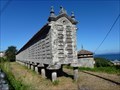
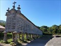 view gallery view gallerySW13.5 km |  Hórreo de Carnota - Carnota, A Coruña, España Hórreo de Carnota - Carnota, A Coruña, España
in Elevated Buildings Con el de Lira son los hórreos más representativos del municipio y de los más largos de Galicia, solo superados por el de Araño // With the one in Lira, they are the most representative hórreos in the municipality and one of the longest in Galicia posted by: xeocach location: Galicia, Spain date approved: 02/19/2023 last visited: never |
 view gallery view gallery E14.3 km E14.3 km
| Pedra Arada in Vértices Geodésicos Situada en el extremo norte de una loma alargada, en el ayuntamiento de NEGREIRA posted by: aledrian location: Galicia, Spain date approved: 02/21/2011 last visited: 02/21/2011 |
 view gallery view gallery S14.5 km S14.5 km
| Zorcada - Forcada, Muros (A Coruña) in Vértices Geodésicos Entre Muros e Carnota. posted by: OGolpe location: none listed yet date approved: 05/02/2008 last visited: never |
 view gallery view gallerySW17.1 km | Hórreo de Lira - Carnota, A Coruña, España in Elevated Buildings Con el de Carnota son los hórreos más representativos del municipio y de los más largos de Galicia, solo el de Araño los supera / With the one in Carnota, they are the most representative hórreos in the municipality and one of the longest in Galicia posted by: xeocach location: Galicia, Spain date approved: 02/19/2023 last visited: never |
 view gallery view gallery N17.7 km N17.7 km
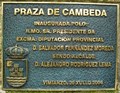
|  Cambeda square - Vimianzo, Spain Cambeda square - Vimianzo, Spain
in Grand Opening The Cambeda square in Vimianzo was inaugurated by D. Jesus Salvador Fernández Moreda The Presidente da Diputación Provincial. posted by: razalas location: Galicia, Spain date approved: 05/12/2015 last visited: never |
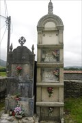 view gallery view galleryN17.7 km |  San Xoán de Cambeda - Vimianzo, ES San Xoán de Cambeda - Vimianzo, ES
in Worldwide Cemeteries This cemetery is around the parish church of Cambeda in the municipality of Vimianzo. posted by: razalas location: Galicia, Spain date approved: 01/22/2015 last visited: never |
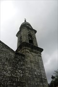 view gallery view galleryN17.7 km |  Igrexa de San Xoán de Cambeda Bell Tower - Vimianzo, ES Igrexa de San Xoán de Cambeda Bell Tower - Vimianzo, ES
in Bell Towers This Bell Tower belongs to the Igrexa de San Xoán de Cambeda that is the parish church of Cambeda. posted by: razalas location: Galicia, Spain date approved: 01/22/2015 last visited: never |
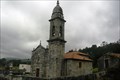 view gallery view galleryN17.7 km |  Igrexa de San Xoán de Cambeda - Vimianzo, ES Igrexa de San Xoán de Cambeda - Vimianzo, ES
in Roman Catholic Churches The Igrexa de San Xoán de Cambeda is the parish church of Cambeda. posted by: razalas location: Galicia, Spain date approved: 01/18/2015 last visited: never |
 view gallery view galleryN17.7 km | Igrexa de San Xoán de Cambeda - Vimianzo, ES in This Old Church The Igrexa de San Xoán de Cambeda is the parish church of Cambeda. posted by: razalas location: Galicia, Spain date approved: 01/16/2015 last visited: never |
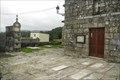 view gallery view galleryN17.7 km |  Igrexa de San Xoán de Cambeda - Vimianzo, ES Igrexa de San Xoán de Cambeda - Vimianzo, ES
in Churchyard Cemeteries This cemetery is around the parish church of Cambeda in the municipality of Vimianzo. posted by: razalas location: Galicia, Spain date approved: 01/22/2015 last visited: never |
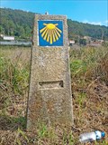 view gallery view galleryW19 km | Way Marker - Castrexe, Spain in Way of St. James Here the Way of St. James connects Muxia to Finisterra along a dirt road crossing an asphalt road. This way marker is placed on the south side of the dirt road. posted by: T0SHEA location: Galicia, Spain date approved: 04/23/2015 last visited: never |
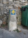
 view gallery view galleryW19 km | Way Marker (dirt road) - Suarriba, Spain in Way of St. James In Suarriba were the Way of St James turns from an asphalt road onto a dirt road you can find this Way Marker. posted by: razalas location: Galicia, Spain date approved: 09/29/2014 last visited: never |
 view gallery view galleryW19 km | Way Marker (asphalt road) - Suarriba, Spain in Way of St. James In Suarriba this is the last way marker on the asphalt road were the Way of St James turns from an asphalt road onto a dirt road. posted by: razalas location: Galicia, Spain date approved: 10/03/2014 last visited: never |
 view gallery view galleryW19 km | Way Marker Buxedo to Suarriba road- Fisterra, Spain in Way of St. James You can find this way marker Halfway in the road that connects Buxedo to Suarriba. This is from the leg of the way of St. James of Muxia to Finisterra. posted by: razalas location: Galicia, Spain date approved: 10/03/2014 last visited: never |
 view gallery view galleryW19.3 km | Buxan Way Marker - Buxan, Spain in Way of St. James You can find this Way Marker in the center of the small town of Buxan. posted by: razalas location: Galicia, Spain date approved: 10/03/2014 last visited: never |
|