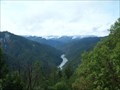
 view gallery view gallery SE19.8 km SE19.8 km
|   Whisky Creek Overlook Whisky Creek Overlook
in Scenic Roadside Look-Outs Scenic overlook above the Rogue River. posted by:  Pacific NW Pacific NW location: Oregon date approved: 03/27/2007 last visited: never |
 view gallery view gallery N23 km N23 km
|  Camas Valley, Oregon 97416 - Contract Postal Unit Camas Valley, Oregon 97416 - Contract Postal Unit
in U.S. Post Offices This Post Office is located at 18493 Highway 42 in Camas Valley, Oregon. posted by:  brwhiz brwhiz location: Oregon date approved: 12/21/2011 last visited: 04/28/2018 |
 view gallery view galleryN23 km |  Camas Valley United Methodist Church - Camas Valley, OR Camas Valley United Methodist Church - Camas Valley, OR
in Methodist Churches A Methodist church in Camas Valley. posted by: NW_history_buff location: Oregon date approved: 07/23/2018 last visited: never |
 view gallery view galleryN23.2 km |  Water Tender, Camas Valley Volunteer Rural Fire District - Camas Valley, OR Water Tender, Camas Valley Volunteer Rural Fire District - Camas Valley, OR
in Fire Fighting Vehicles This is one of two water tenders in use by the Camas Valley Volunteer Rural Fire District. The district covers an area of a small community, farms, and forested land in Douglas County, Oregon. posted by: silverquill location: Oregon date approved: 05/28/2009 last visited: never |
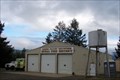 view gallery view galleryN23.2 km | Camas Valley Volunteer Rural Fire District in Firehouses This rural fire station serves an area encompassing a small community, farms and forested areas in Douglas County, Oregon. The main access road through here is US Hwy 42. posted by: silverquill location: Oregon date approved: 05/28/2009 last visited: never |
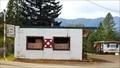 view gallery view galleryN23.3 km |  Rerun Books Barn Quilt - Camas Valley, OR Rerun Books Barn Quilt - Camas Valley, OR
in Painted Barn Quilts A barn quilt located in front of a used book store. posted by: NW_history_buff location: Oregon date approved: 07/23/2018 last visited: never |
 view gallery view gallery NW24 km NW24 km
| Remote, OR 97468 {Retired} in U.S. Post Offices The store and post office at Remote, Oregon, used to be a landmark on Highway 42 between Roseburg and Coos Bay on the coast. New routing bypassed this building, but there is still a loop through all that is left of the town. Great wild blackberries! posted by: silverquill location: Oregon date approved: 10/23/2008 last visited: 11/15/2011 |
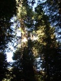 view gallery view gallery W24 km W24 km
|  LARGEST - Port Orford Cedar Tree in the World - Powers, OR LARGEST - Port Orford Cedar Tree in the World - Powers, OR
in Superlatives Known locally simply as "Big Tree," this is the largest Port Orford tree in the world towering 232 ft (70.7m) with a circumference of 43.5 ft (13.3m)and a spread of 35 ft (10.7m). The aromatic wood is highly prized, and grows only in this area. posted by: silverquill location: Oregon date approved: 06/03/2009 last visited: never |
 view gallery view galleryW24 km |  Largest Port Orford Cedar Tree in the World - Powers, OR Largest Port Orford Cedar Tree in the World - Powers, OR
in Exceptional Trees Known locally simply as "Big Tree," this is the largest Port Orford tree in the world towering 232 ft (70.7m) with a circumference of 43.5 ft (13.3m)and a spread of 35 ft (10.7m). The aromatic wood is highly prized, and grows only in this area. posted by: silverquill location: Oregon date approved: 06/05/2009 last visited: never |
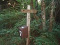 view gallery view galleryW24 km |  Elk Creek Falls Upper Trail Register - Powers, OR Elk Creek Falls Upper Trail Register - Powers, OR
in Trail Registers From the Big Tree Recreational Area, a trail leads down to Elk Creek Falls. From the parking area, follow the trail to the Big Tree (the world's largest Port Orford cedar tree) and sign this register at the trail junction. posted by: silverquill location: Oregon date approved: 06/04/2009 last visited: never |
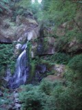 view gallery view galleryW24 km |  Elk Creek Falls - Powers, OR Elk Creek Falls - Powers, OR
in Waterfalls There is a moderate trail leading up to a nice view point at the base of this 32-ft fall in the Rogue-Siskiyou National Forest of southwest Oregon. Another branch of the trail ascends to the site of the world's largest Port Orford cedar tree. posted by: silverquill location: Oregon date approved: 06/05/2009 last visited: never |
 view gallery view galleryW24.1 km |  Elk Creek Falls Trail - Powers, OR Elk Creek Falls Trail - Powers, OR
in Scenic Hikes This trail offers more than a mile of serene hiking through the Rogue-Siskiyou National Forest with a scenic view of Elk Creek Falls, and another branch ascending to the Big Tree recreation area, location of the world's largest Port Orford Cedar Tree posted by: silverquill location: Oregon date approved: 06/03/2009 last visited: never |
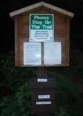 view gallery view galleryW24.1 km | Elk Creek Falls Trailhead Register - Powers, OR in Trail Registers This trail offers more than a mile of serene hiking through the Rogue-Siskiyou National Forest with a scenic view of Elk Creek Falls, and another branch ascending to the Big Tree recreation area, location of the world's largest Port Orford Cedar Tree posted by: silverquill location: Oregon date approved: 06/04/2009 last visited: never |
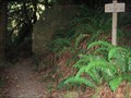 view gallery view galleryW24.1 km |  Elk Creek Falls Trailhead - Powers, OR Elk Creek Falls Trailhead - Powers, OR
in Hiking and walking trailheads This trail offers more than a mile of serene hiking through the Rogue-Siskiyou National Forest with a scenic view of Elk Creek Falls, and another branch ascending to the Big Tree recreation area, location of the world's largest Port Orford Cedar Tree posted by: silverquill location: Oregon date approved: 06/03/2009 last visited: never |
 view gallery view gallery SW24.3 km SW24.3 km
| Bear Camp Overlook - Oregon in Scenic Roadside Look-Outs Viewpoint on Bear Camp Road between the communities of Galice and Agness. posted by: Volcanoguy location: Oregon date approved: 12/12/2009 last visited: 08/29/2009 |
 view gallery view galleryNW24.5 km | ONLY - Covered Highway Bridge in Coos County, OR in Superlatives Sandy Creek Bridge, built in 1921, is Coos County's only covered bridge and was listed in the National Register of Historic Places in 1979. posted by: NW_history_buff location: Oregon date approved: 07/23/2018 last visited: never |
 view gallery view galleryNW24.5 km |  Sandy Creek Bridge - Coos County, OR Sandy Creek Bridge - Coos County, OR
in Orphaned Bridges Sandy Creek Bridge, built in 1921, is Coos County's only covered bridge and was listed in the National Register of Historic Places in 1979 posted by: NW_history_buff location: Oregon date approved: 07/22/2018 last visited: never |
 view gallery view galleryNW24.5 km |  Sandy Creek Bridge - Remote, OR Sandy Creek Bridge - Remote, OR
in Covered Bridges Built in 1921, the 60-foot long Sandy Creek covered bridge carried traffic on Oregon Highway 42 until it was bypassed in 1949. The bridge is strengthened by two crossed Howe truss members on each chord, a rarity in short covered bridges. posted by: silverquill location: Oregon date approved: 12/24/2007 last visited: 04/28/2018 |
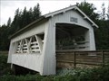 view gallery view galleryNW24.5 km |  Sandy Creek Bridge - Remote, OR Sandy Creek Bridge - Remote, OR
in U.S. National Register of Historic Places Built in 1921, the 60-foot long Sandy Creek covered bridge carried traffic on Oregon Highway 42 until it was bypassed in 1949. The bridge is strengthened by two crossed Howe truss members on each chord, a rarity in short covered bridges. posted by: silverquill location: Oregon date approved: 12/23/2007 last visited: 04/28/2018 |
 view gallery view gallerySE25.7 km | Glendale, Oregon 97442 in U.S. Post Offices This Post Office is located at 358 Pacific Avenue in Glendale, Oregon. posted by: brwhiz location: Oregon date approved: 12/21/2011 last visited: never |
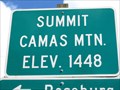 view gallery view galleryN26.6 km |  Camas Mtn Summit - Camas Valley, OR - 1448' Camas Mtn Summit - Camas Valley, OR - 1448'
in Elevation Signs The sign is on Highway 42 northeast of Camas Valley. posted by: WR7X location: Oregon date approved: 05/12/2014 last visited: never |
 view gallery view gallerySW27.4 km | Shasta Costa Overlook - Oregon in Scenic Roadside Look-Outs Viewpoint on Bear Camp Road between the communities of Galice and Agness. posted by: Volcanoguy location: Oregon date approved: 12/12/2009 last visited: 08/29/2009 |
 view gallery view gallerySE27.7 km | Rand Ranger Station in U.S. National Register of Historic Places The historic Rand Ranger Station near Galice, Oregon. posted by: Volcanoguy location: Oregon date approved: 12/12/2009 last visited: 08/29/2009 |
 view gallery view gallerySE27.7 km |  Smullin Visitor Center - Galice, Oregon Smullin Visitor Center - Galice, Oregon
in Tourist Information Centers - Visitor Centers The Smullin Visitor Center at the National Historic Site near Galice, Oregon. posted by: Volcanoguy location: Oregon date approved: 12/09/2009 last visited: 08/29/2009 |
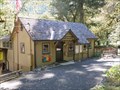 view gallery view gallerySE27.7 km |  Rand Ranger Station - Oregon Rand Ranger Station - Oregon
in Civilian Conservation Corps The historic Rand Ranger Station near Galice, Oregon was partially constructed by the CCCs. posted by: Volcanoguy location: Oregon date approved: 12/10/2009 last visited: 08/29/2009 |
|