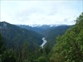
 view gallery view gallery N1.3 km N1.3 km
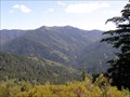
|   Bear Camp Overlook - Oregon Bear Camp Overlook - Oregon
in Scenic Roadside Look-Outs Viewpoint on Bear Camp Road between the communities of Galice and Agness. posted by:  Volcanoguy Volcanoguy location: Oregon date approved: 12/12/2009 last visited: 08/29/2009 |
 view gallery view gallery W6.6 km W6.6 km
| Shasta Costa Overlook - Oregon in Scenic Roadside Look-Outs Viewpoint on Bear Camp Road between the communities of Galice and Agness. posted by: Volcanoguy location: Oregon date approved: 12/12/2009 last visited: 08/29/2009 |
 view gallery view gallery SE10.6 km SE10.6 km
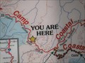
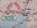
|  Bear Camp Coastal Route sign #2, Oregon Bear Camp Coastal Route sign #2, Oregon
in 'You Are Here' Maps Map board showing the Bear Camp Coastal Route.
posted by: Volcanoguy location: Oregon date approved: 12/11/2009 last visited: 08/29/2009 |
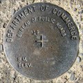
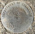
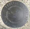 view gallery view gallerySE15.3 km |  FHWA North Fork Galice Creek, Oregon FHWA North Fork Galice Creek, Oregon
in U.S. Benchmarks Blank FHWA cap on Bear Camp Route. posted by: Volcanoguy location: Oregon date approved: 12/13/2009 last visited: 08/29/2009 |
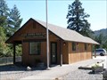 view gallery view galleryW19.2 km |  Agness, OR. 97406 Agness, OR. 97406
in U.S. Post Offices The post office building in Agness, OR. posted by: Volcanoguy location: Oregon date approved: 09/09/2009 last visited: 08/29/2009 |
 view gallery view gallery E19.2 km E19.2 km
| Whisky Creek Overlook in Scenic Roadside Look-Outs Scenic overlook above the Rogue River. posted by:  Pacific NW Pacific NW location: Oregon date approved: 03/27/2007 last visited: never |
 view gallery view gallery SW19.3 km SW19.3 km
| BPR Illinois River Bridge #1, Oregon in U.S. Benchmarks One of three blank BPR benchmark caps on Illinois River Bridge. posted by: Volcanoguy location: Oregon date approved: 12/12/2009 last visited: 08/29/2009 |
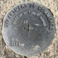 view gallery view gallerySW19.5 km | BPR Illinois River Bridge #2, Oregon in U.S. Benchmarks One of three blank BPR benchmark caps on Illinois River Bridge. posted by: Volcanoguy location: Oregon date approved: 12/12/2009 last visited: 12/13/2009 |
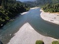 view gallery view gallerySW19.5 km |  CONFLUENCE - Illinois River - Rogue River CONFLUENCE - Illinois River - Rogue River
in River Origins, Destinations and Confluences The confluence of Illinois River with the Rogue River. posted by: Volcanoguy location: Oregon date approved: 12/22/2009 last visited: 08/31/2009 |
 view gallery view gallerySW19.6 km | BPR Illinois River Bridge #3, Oregon in U.S. Benchmarks One of three blank BPR benchmark caps on Illinois River Bridge. posted by: Volcanoguy location: Oregon date approved: 12/12/2009 last visited: 08/29/2009 |
 view gallery view galleryE20.4 km | Bear Camp Coastal Route sign #1, Oregon in 'You Are Here' Maps Map board showing the Bear Camp Coastal Route. posted by: Volcanoguy location: Oregon date approved: 12/11/2009 last visited: 07/17/2012 |
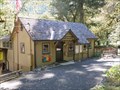
 view gallery view galleryE21.6 km |  Smullin Visitor Center - Galice, Oregon Smullin Visitor Center - Galice, Oregon
in Tourist Information Centers - Visitor Centers The Smullin Visitor Center at the National Historic Site near Galice, Oregon. posted by: Volcanoguy location: Oregon date approved: 12/09/2009 last visited: 08/29/2009 |
 view gallery view galleryE21.6 km |  Rand Ranger Station - Oregon Rand Ranger Station - Oregon
in Civilian Conservation Corps The historic Rand Ranger Station near Galice, Oregon was partially constructed by the CCCs. posted by: Volcanoguy location: Oregon date approved: 12/10/2009 last visited: 08/29/2009 |
 view gallery view galleryE21.6 km |  Rand Ranger Station Rand Ranger Station
in U.S. National Register of Historic Places The historic Rand Ranger Station near Galice, Oregon. posted by: Volcanoguy location: Oregon date approved: 12/12/2009 last visited: 08/29/2009 |
 view gallery view galleryE21.6 km |  Smullin Visitor Center Signs - Josephine County, Oregon Smullin Visitor Center Signs - Josephine County, Oregon
in Oregon Historical Markers Three history signs about Rand in the historic Smullin Visitor Center building. posted by: Volcanoguy location: Oregon date approved: 12/10/2009 last visited: 08/29/2009 |
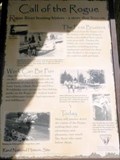 view gallery view galleryE21.6 km | Call of the Rogue - Josephine County, Oregon in Oregon Historical Markers Outdoor history sign at the Rand Visitor Center. posted by: Volcanoguy location: Oregon date approved: 12/09/2009 last visited: 07/17/2012 |
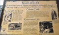 view gallery view galleryE21.6 km | River of Life - Josephine County, Oregon in Oregon Historical Markers Outdoor history sign at the Rand Visitor Center. posted by: Volcanoguy location: Oregon date approved: 12/09/2009 last visited: 07/17/2012 |
 view gallery view gallery NW24.9 km NW24.9 km
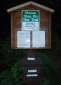
|  Elk Creek Falls Upper Trail Register - Powers, OR Elk Creek Falls Upper Trail Register - Powers, OR
in Trail Registers From the Big Tree Recreational Area, a trail leads down to Elk Creek Falls. From the parking area, follow the trail to the Big Tree (the world's largest Port Orford cedar tree) and sign this register at the trail junction. posted by: silverquill location: Oregon date approved: 06/04/2009 last visited: never |
 view gallery view galleryNW24.9 km |  Largest Port Orford Cedar Tree in the World - Powers, OR Largest Port Orford Cedar Tree in the World - Powers, OR
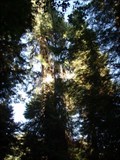
in Exceptional Trees Known locally simply as "Big Tree," this is the largest Port Orford tree in the world towering 232 ft (70.7m) with a circumference of 43.5 ft (13.3m)and a spread of 35 ft (10.7m). The aromatic wood is highly prized, and grows only in this area. posted by: silverquill location: Oregon date approved: 06/05/2009 last visited: never |
 view gallery view galleryNW24.9 km |  LARGEST - Port Orford Cedar Tree in the World - Powers, OR LARGEST - Port Orford Cedar Tree in the World - Powers, OR
in Superlatives Known locally simply as "Big Tree," this is the largest Port Orford tree in the world towering 232 ft (70.7m) with a circumference of 43.5 ft (13.3m)and a spread of 35 ft (10.7m). The aromatic wood is highly prized, and grows only in this area. posted by: silverquill location: Oregon date approved: 06/03/2009 last visited: never |
 view gallery view galleryNW25.9 km |  Elk Creek Falls - Powers, OR Elk Creek Falls - Powers, OR
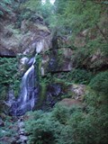
in Waterfalls There is a moderate trail leading up to a nice view point at the base of this 32-ft fall in the Rogue-Siskiyou National Forest of southwest Oregon. Another branch of the trail ascends to the site of the world's largest Port Orford cedar tree. posted by: silverquill location: Oregon date approved: 06/05/2009 last visited: never |
 view gallery view galleryNW26.1 km |  Elk Creek Falls Trail - Powers, OR Elk Creek Falls Trail - Powers, OR
in Scenic Hikes This trail offers more than a mile of serene hiking through the Rogue-Siskiyou National Forest with a scenic view of Elk Creek Falls, and another branch ascending to the Big Tree recreation area, location of the world's largest Port Orford Cedar Tree posted by: silverquill location: Oregon date approved: 06/03/2009 last visited: never |
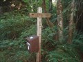
 view gallery view galleryNW26.1 km | Elk Creek Falls Trailhead Register - Powers, OR in Trail Registers This trail offers more than a mile of serene hiking through the Rogue-Siskiyou National Forest with a scenic view of Elk Creek Falls, and another branch ascending to the Big Tree recreation area, location of the world's largest Port Orford Cedar Tree posted by: silverquill location: Oregon date approved: 06/04/2009 last visited: never |
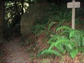 view gallery view galleryNW26.1 km |  Elk Creek Falls Trailhead - Powers, OR Elk Creek Falls Trailhead - Powers, OR
in Hiking and walking trailheads This trail offers more than a mile of serene hiking through the Rogue-Siskiyou National Forest with a scenic view of Elk Creek Falls, and another branch ascending to the Big Tree recreation area, location of the world's largest Port Orford Cedar Tree posted by: silverquill location: Oregon date approved: 06/03/2009 last visited: never |
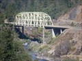 view gallery view galleryE27.2 km |  Hellgate Bridge - near Merlin, Oregon Hellgate Bridge - near Merlin, Oregon
in Truss Bridges The Hellgate Bridge across the Rogue River on the Galice Road. posted by: Volcanoguy location: Oregon date approved: 12/08/2009 last visited: 07/17/2012 |
|