 view gallery view gallery SW5.5 km SW5.5 km
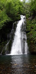
|   Fervenza de Vieiros - Quiroga, Lugo, España Fervenza de Vieiros - Quiroga, Lugo, España
in Waterfalls Fervenza no río Selmo // Waterfall in the Selmo River posted by:  xeocach xeocach location: Galicia, Spain date approved: 07/18/2023 last visited: never |
 view gallery view gallery N11.3 km N11.3 km
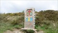
|  Galicia and Leon border in Spain Galicia and Leon border in Spain
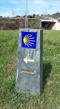
in Border Crossings Entering Galicia on the camino de santiago on the border with Castilla y Leon. posted by: sassainfl location: Galicia, Spain date approved: 09/25/2010 last visited: 07/06/2015 |
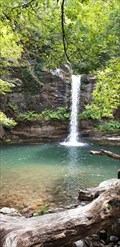 view gallery view gallerySW12.2 km | Fervenza do Pombar - Quiroga, Lugo, España in Waterfalls Fervenza no río Quiroga // Waterfall in the Quiroga River posted by: xeocach location: Galicia, Spain date approved: 07/19/2023 last visited: never |
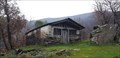
 view gallery view galleryN12.2 km |  Palloza at O'Cebreiro Palloza at O'Cebreiro
in Thatch Cottages Palloza at the Celtic Village O'Cebreiro near the border between Galicia and Castilla y Leon provinces on the Camino de Santiago. posted by: sassainfl location: Galicia, Spain date approved: 09/22/2010 last visited: 02/16/2011 |
 view gallery view gallery W17.9 km W17.9 km
|  Capela de San Roque - Vilar, Folgoso do Courel, Lugo, España Capela de San Roque - Vilar, Folgoso do Courel, Lugo, España
in Waychapels Situada nun promontorio sobre o río Lor // Located on a promontory above the Lor river posted by: xeocach location: Galicia, Spain date approved: 05/31/2023 last visited: never |
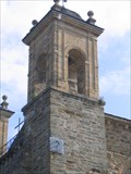 view gallery view gallery E18 km E18 km
|  Camino Sundial on San Francisco Church, Villefranca, Spain Camino Sundial on San Francisco Church, Villefranca, Spain
in Sundials On the south west tower of San Fracisco Church is a simple sundial engraved in slate. posted by:  arby101ca arby101ca location: Castilla y León, Spain date approved: 03/04/2010 last visited: 05/11/2008 |
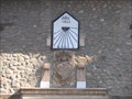 view gallery view galleryE18 km | Sundial along the Camino, Villafranca del Bierzo, Spain in Sundials On Caixa Galacia in Villafranca del Bierzo is a vertical sundial dated 1822. posted by: arby101ca location: Castilla y León, Spain date approved: 03/04/2010 last visited: 05/29/2005 |
 view gallery view gallerySW18.5 km |  Dobra Campodola Leixazós - Quiroga, Lugo, España Dobra Campodola Leixazós - Quiroga, Lugo, España
in Places of Geologic Significance A dobra deitada das Montañas do Courel // El Pliegue acostado de las Montañas do Courel // The recumbed fold of Courel Mountains posted by: xeocach location: Galicia, Spain date approved: 09/05/2023 last visited: never |
 view gallery view gallerySW18.5 km |  Xeoparque Montañas do Courel - Quiroga, Lugo, España Xeoparque Montañas do Courel - Quiroga, Lugo, España
in UNESCO Geoparks and Biosphere Reserves O primeiro xeoparque de Galicia obtivo este recoñecemento no 2019 // The first geopark in Galicia obtained this recognition in 2019 posted by: xeocach location: Galicia, Spain date approved: 09/05/2023 last visited: never |
 view gallery view gallery S20.4 km S20.4 km
|  O Barco se anuncia colocando grandes letras de pizarra - O Barco de Valdeorras, Ourense, España O Barco se anuncia colocando grandes letras de pizarra - O Barco de Valdeorras, Ourense, España
in News Article Locations Noticia sobre la colocación del nombre de la villa en letras gigantes en la rotonda de Veigamuiños // News about the placement of the name of the town in giant letters in the Veigamuiños roundabout posted by: xeocach location: Galicia, Spain date approved: 03/04/2023 last visited: never |
 view gallery view galleryS20.4 km |  O Barco - O Barco de Valdeorras, Ourense, España O Barco - O Barco de Valdeorras, Ourense, España
in City Names in Giant Letters En una de las entradas a O Barco desde la N-120 una rotonda nos da la bienvenida con el nombre de la villa en letras gigantes // At one of the entrances to O Barco from the N-120, a roundabout welcomes us with the name of the town in giant letters posted by: xeocach location: Comunidad de Madrid, Spain date approved: 03/04/2023 last visited: never |
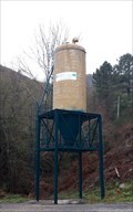 view gallery view gallerySW20.8 km |  LU-651 km 5 - Quiroga, Lugo, España LU-651 km 5 - Quiroga, Lugo, España
in Solitary Silos Silode vialidad invernal // Winter road silo posted by: xeocach location: Galicia, Spain date approved: 01/14/2023 last visited: never |
 view gallery view galleryS20.9 km |  Km 208,779 do Camiño de Inverno - A Proba, O Barco de Valdeorras, Ourense, España Km 208,779 do Camiño de Inverno - A Proba, O Barco de Valdeorras, Ourense, España
in Way of St. James A Catedral compostelá está a 208,779 km // Compostela Cathedral is 208,779 km away posted by: xeocach location: Galicia, Spain date approved: 07/26/2023 last visited: never |
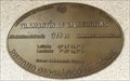
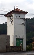
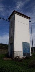 view gallery view galleryS20.9 km |  32CB73 - A Proba, O Barco de Valdeorras, Ourense, España 32CB73 - A Proba, O Barco de Valdeorras, Ourense, España
in Historic Transformer Sub-Stations Buildings Subestación transformadora ubicada en A Proba // Transformer substation tower located in A Proba posted by: xeocach location: Galicia, Spain date approved: 08/04/2023 last visited: never |
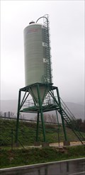 view gallery view galleryS20.9 km | Silo en A Proba - O Barco de Valdeorras, Ourense, España in Solitary Silos Silo de vialidad invernal // Winter road silo posted by: xeocach location: Galicia, Spain date approved: 01/28/2023 last visited: never |
 view gallery view galleryS21.2 km | Km 207,626 do Camiño de Inverno - Arcos, Vilamartín de Valdeorras, Ourense, España in Way of St. James A Catedral compostelá está a 207,626 km // Compostela Cathedral is 207,626 km away posted by: xeocach location: Galicia, Spain date approved: 05/30/2023 last visited: never |
 view gallery view galleryS21.2 km | Km 212,354 do Camiño de Inverno - O Barco de Valdeorras, Ourense, España in Way of St. James A Catedral compostelá está a 212,354 km // Compostela Cathedral is 212,354 km away posted by: xeocach location: Galicia, Spain date approved: 07/26/2023 last visited: never |
 view gallery view galleryS21.2 km |  N 42° 24' 55,8'' W 7° 03' 51,5'' - Vilamartín de Valdeorras, Ourense, España N 42° 24' 55,8'' W 7° 03' 51,5'' - Vilamartín de Valdeorras, Ourense, España
in Permanent Geographic Coordinates Punto de referencia en la fachada de la Casa Consistorial con Coordenadas Geográficas Permanentes grabadas // Benchmark on the facade of the Town Hall with Permanent Geographic Coordinates engraved posted by: xeocach location: Galicia, Spain date approved: 12/30/2022 last visited: never |
 view gallery view galleryS21.2 km |  318m - Vilamartín de Valdeorras, Ourense, España 318m - Vilamartín de Valdeorras, Ourense, España
in Elevation Signs Elevación sobre el nivel medio del Mediterráneo en Alicante // Elevation above the mean level of the Mediterranean Sea in Alicante posted by: xeocach location: Galicia, Spain date approved: 12/30/2022 last visited: never |
 view gallery view galleryS21.2 km |  Vilamartín de Valdeorras - Ourense, España Vilamartín de Valdeorras - Ourense, España
in Vértices Geodésicos Marca de nivel en la fachada de la Casa Consistorial con Coordenadas Geográficas Permanentes grabadas // Level mark on the facade of the Town Hall with Permanent Geographic Coordinates posted by: xeocach location: Galicia, Spain date approved: 01/04/2023 last visited: never |
 view gallery view galleryS21.2 km | O Barco de Valdeorras - Ourense, España in Vértices Geodésicos Punto de referencia en la fachada de la Casa Consistorial con Coordenadas Geográficas Permanentes grabadas // Benchmark on the facade of the Town Hall with Permanent Geographic Coordinates engraved posted by: xeocach location: Galicia, Spain date approved: 12/10/2022 last visited: never |
 view gallery view galleryS21.2 km | 325m - O Barco, Ourense, España in Elevation Signs Elevación sobre el nivel medio del Mediterráneo en Alicante // Elevation above the mean level of the Mediterranean Sea in Alicante posted by: xeocach location: Galicia, Spain date approved: 12/08/2022 last visited: never |
 view gallery view galleryS21.2 km | N 42º 24’ 59,2’’ W 6º 59’ 04,7’’ - O Barco, Ourense, España in Permanent Geographic Coordinates Punto de referencia en la fachada de la Casa Consistorial con Coordenadas Geográficas Permanentes grabadas // Benchmark on the facade of the Town Hall with Permanent Geographic Coordinates engraved posted by: xeocach location: Galicia, Spain date approved: 12/15/2022 last visited: never |
 view gallery view galleryS21.4 km | 32CB83 - Vilamartín de Valdeorras, Ourense, España in Historic Transformer Sub-Stations Buildings Subestación transformadora ubicada en calle Carmen Padilla de Vilamartín de Valdeorras // Transformer substation tower located in Vilamartín de Valdeorras posted by: xeocach location: Galicia, Spain date approved: 01/29/2023 last visited: never |
 view gallery view galleryS21.6 km | Banco Peregrino - O Barco de Valdeorras, Ourense, España in Way of St. James Un repouso antes de retomar o Camiño de Inverno // A rest before resuming the Winter’s Way of St. James posted by: xeocach location: Galicia, Spain date approved: 01/13/2024 last visited: never |
|