 view gallery view gallery N1.6 km N1.6 km
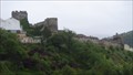
|   Monasterio de Santa María de Carracedo - Carracedelo, León, España Monasterio de Santa María de Carracedo - Carracedelo, León, España
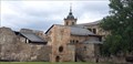
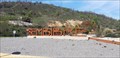
in Abbeys, Convents and Monasteries Antigua abadía fundada en el siglo X y perteneciente a las órdenes benedictina y, posteriormente, cisterciense // Former abbey founded in the 10th century and belonging to the Benedictine and later Cistercian orders – BIC since 1929 posted by:  xeocach xeocach location: Castilla y León, Spain date approved: 05/22/2023 last visited: never |
 view gallery view galleryN1.6 km |  Monasterio de Santa María de Carracedo - Carracedelo, León, España Monasterio de Santa María de Carracedo - Carracedelo, León, España
in Wikipedia Entries Antigua abadía fundada en el siglo X y perteneciente a las órdenes benedictina y, posteriormente, cisterciense // Former abbey founded in the 10th century and belonging to the Benedictine and later Cistercian orders – BIC since 1929 posted by: xeocach location: Castilla y León, Spain date approved: 05/22/2023 last visited: never |
 view gallery view galleryN1.6 km |  Monasterio de Santa María de Carracedo - Carracedelo, León, España Monasterio de Santa María de Carracedo - Carracedelo, León, España
in Official Local Tourism Attractions Antigua abadía fundada en el siglo X y perteneciente a las órdenes benedictina y, posteriormente, cisterciense // Former abbey founded in the 10th century and belonging to the Benedictine and later Cistercian orders – BIC since 1929 posted by: xeocach location: Castilla y León, Spain date approved: 05/22/2023 last visited: never |
 view gallery view galleryN1.6 km |  Monasterio de Santa María de Carracedo - Carracedelo, León, España Monasterio de Santa María de Carracedo - Carracedelo, León, España
in Spanish Heritage Antigua abadía fundada en el siglo X y perteneciente a las órdenes benedictina y, posteriormente, cisterciense // Former abbey founded in the 10th century and belonging to the Benedictine and later Cistercian orders – BIC since 1929 posted by: xeocach location: Castilla y León, Spain date approved: 05/22/2023 last visited: never |
 view gallery view gallery NW8.4 km NW8.4 km
|  Sundial along the Camino, Villafranca del Bierzo, Spain Sundial along the Camino, Villafranca del Bierzo, Spain
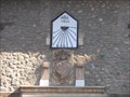
in Sundials On Caixa Galacia in Villafranca del Bierzo is a vertical sundial dated 1822. posted by:  arby101ca arby101ca location: Castilla y León, Spain date approved: 03/04/2010 last visited: 05/29/2005 |
 view gallery view galleryNW8.7 km | Camino Sundial on San Francisco Church, Villefranca, Spain in Sundials On the south west tower of San Fracisco Church is a simple sundial engraved in slate. posted by: arby101ca location: Castilla y León, Spain date approved: 03/04/2010 last visited: 05/11/2008 |
 view gallery view gallery S11.1 km S11.1 km
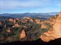
| Las Médulas - León, España in Wikipedia Entries Paisaje espectacular formado como resultado de la explotación aurífera romana // Spectacular landscape formed as a result of Roman gold mining posted by: xeocach location: Castilla y León, Spain date approved: 02/08/2023 last visited: never |
 view gallery view galleryS11.1 km |  Las Médulas - León, España Las Médulas - León, España
in World Heritage Sites Paisaje espectacular formado como resultado de la explotación aurífera romana // Spectacular landscape formed as a result of Roman gold mining posted by: xeocach location: Castilla y León, Spain date approved: 02/08/2023 last visited: never |
 view gallery view galleryS11.1 km | Las Médulas - León, España in Official Local Tourism Attractions Paisaje espectacular formado como resultado de la explotación aurífera romana // Spectacular landscape formed as a result of Roman gold mining posted by: xeocach location: Castilla y León, Spain date approved: 02/09/2023 last visited: never |
 view gallery view galleryS11.1 km |  Las Médulas - León, España Las Médulas - León, España
in Ancient Roman Civilization Paisaje espectacular formado como resultado de la explotación aurífera romana // Spectacular landscape formed as a result of Roman gold mining posted by: xeocach location: Castilla y León, Spain date approved: 02/09/2023 last visited: never |
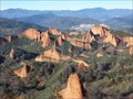 view gallery view galleryS11.1 km | Las Médulas - León, España in Spanish Heritage Paisaje espectacular formado como resultado de la explotación aurífera romana // Spectacular landscape formed as a result of Roman gold mining
- BIC since 1998 posted by: xeocach location: Castilla y León, Spain date approved: 02/21/2023 last visited: never |
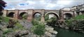
 view gallery view gallery E11.6 km E11.6 km
|  Templar Castle in Ponferrada, Spain Templar Castle in Ponferrada, Spain
in Castles Castillo de los Templarios in Spanish, a Templar castle which covers approximately 16,000 square meters. It stands intact and can be visited. posted by: sassainfl location: Castilla y León, Spain date approved: 09/24/2010 last visited: 07/26/2023 |
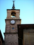 view gallery view galleryE11.7 km |  Torre del Reloj - Ponferrada, Spain Torre del Reloj - Ponferrada, Spain
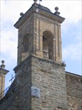
in Town Clocks La Torre del Reloj se encuentra en el acceso a la Calle del Reloj, sobre el Arco de las Eras. Fue construida en el Siglo XVI, durante el reinado de Carlos I. posted by: atin location: Castilla y León, Spain date approved: 04/20/2009 last visited: 07/27/2023 |
 view gallery view gallery SW21.6 km SW21.6 km
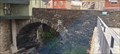
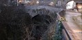
|  Ponte Nova - Sobradelo, Ourense, España Ponte Nova - Sobradelo, Ourense, España
in Arch Bridges Cruza el río Sil desde la segunda mitad del siglo XVII // Crosses the River Sil since the second half of the 17th century posted by: xeocach location: Galicia, Spain date approved: 05/07/2024 last visited: never |
 view gallery view gallerySW21.6 km |  La Ponte Nova de Sobradelo prueba la nueva iluminación - Sobradelo, Ourense, España La Ponte Nova de Sobradelo prueba la nueva iluminación - Sobradelo, Ourense, España
in News Article Locations En Somos Comarca nos hablaron de la nueva iluminación de este puente // In Somos Comarca they told us about the new lighting of this bridge posted by: xeocach location: Galicia, Spain date approved: 05/07/2024 last visited: never |
 view gallery view gallerySW21.7 km |  Ponte Casaio - Sobradelo, Ourense, España Ponte Casaio - Sobradelo, Ourense, España
in Orphaned Bridges Puente de un solo arco sobre el río Casaio // Single arch bridge over the Casaio River posted by: xeocach location: Galicia, Spain date approved: 05/07/2024 last visited: never |
 view gallery view gallerySW21.7 km | Ponte Casaio - Sobradelo, Ourense, España in Arch Bridges Puente de un solo arco sobre el río Casaio // Single arch bridge over the Casaio River posted by: xeocach location: Galicia, Spain date approved: 05/07/2024 last visited: never |
 view gallery view gallerySW22.4 km |  Ponte de Éntoma - O Barco de Valdeorras, Ourense, España Ponte de Éntoma - O Barco de Valdeorras, Ourense, España
in Stone Bridges Puente sobre el río Galir // Bridge over the Galir river posted by: xeocach location: Galicia, Spain date approved: 01/19/2023 last visited: never |
 view gallery view gallerySW22.4 km | Ponte de Éntoma - O Barco de Valdeorras, Ourense, España in Arch Bridges Puente sobre el río Galir // Bridge over the Galir river posted by: xeocach location: Galicia, Spain date approved: 01/14/2023 last visited: never |
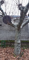 view gallery view gallerySW22.7 km |  Árbol glotón en Éntoma - O Barco de Valdeorras, Ourense, España Árbol glotón en Éntoma - O Barco de Valdeorras, Ourense, España
in Omnivorous Trees Un platanero de sombra (platanus hispanica) muy glotón // A very gluttonous platanus hispanica posted by: xeocach location: Galicia, Spain date approved: 01/13/2023 last visited: never |
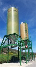 view gallery view galleryE24.9 km |  N-6 Km368 - Bembibre, León, España N-6 Km368 - Bembibre, León, España
in Solitary Silos Dos silos de vialidad invernal // Two winter road silo posted by: xeocach location: Castilla y León, Spain date approved: 04/12/2023 last visited: never |
 view gallery view galleryE25.3 km |  Bembibre - León, España Bembibre - León, España
in City Names in Giant Letters Bembibre en letras gigantes 3D // Bembibre in giant 3D letters posted by: xeocach location: Castilla y León, Spain date approved: 04/12/2023 last visited: never |
 view gallery view gallerySW25.7 km |  Banco Peregrino - O Barco de Valdeorras, Ourense, España Banco Peregrino - O Barco de Valdeorras, Ourense, España
in Way of St. James Un repouso antes de retomar o Camiño de Inverno // A rest before resuming the Winter’s Way of St. James posted by: xeocach location: Galicia, Spain date approved: 01/13/2024 last visited: never |
 view gallery view gallerySW25.7 km |  N 42º 24’ 59,2’’ W 6º 59’ 04,7’’ - O Barco, Ourense, España N 42º 24’ 59,2’’ W 6º 59’ 04,7’’ - O Barco, Ourense, España
in Permanent Geographic Coordinates Punto de referencia en la fachada de la Casa Consistorial con Coordenadas Geográficas Permanentes grabadas // Benchmark on the facade of the Town Hall with Permanent Geographic Coordinates engraved posted by: xeocach location: Galicia, Spain date approved: 12/15/2022 last visited: never |
 view gallery view gallerySW25.7 km |  325m - O Barco, Ourense, España 325m - O Barco, Ourense, España
in Elevation Signs Elevación sobre el nivel medio del Mediterráneo en Alicante // Elevation above the mean level of the Mediterranean Sea in Alicante posted by: xeocach location: Galicia, Spain date approved: 12/08/2022 last visited: never |
|