 view gallery view gallery W26.1 km W26.1 km
|   T30N R86W S23 S24 S25 S26 - Natrona County, Wyoming T30N R86W S23 S24 S25 S26 - Natrona County, Wyoming
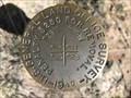
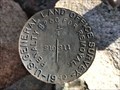
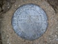
in Public Land Survey Marks A GLO section corner marker to the northeast of County Road 321 (Dry Creek Road). posted by:  Tom.dog Tom.dog location: Wyoming date approved: 05/08/2023 last visited: never |
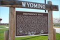
 view gallery view galleryW29.6 km |  Independence Rock - Wyoming Independence Rock - Wyoming
in American Guide Series This location was famous along the Oregon trail as a place to inscribe your name as you passed by. Many emmigrants left home in the spring, hoping to make it to Independence Rock by July 4th, when people on the trail would gather for a party. posted by:  Hikenutty Hikenutty location: Wyoming date approved: 09/07/2007 last visited: 09/07/2019 |
 view gallery view galleryW29.6 km |  Oregon Trail - Independence Rock - Wyoming Oregon Trail - Independence Rock - Wyoming
in Wagon Roads and Trails This location was famous along the Oregon trail as a place to inscribe your name as you passed by. Many emmigrants left home in the spring, hoping to make it to Independence Rock by July 4th, when people on the trail would gather for a party. posted by: Hikenutty location: Wyoming date approved: 07/19/2007 last visited: 09/07/2019 |
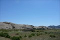 view gallery view galleryW29.6 km |  Independence Rock - Wyoming Independence Rock - Wyoming
in U.S. National Register of Historic Places This location was famous along the Oregon trail as a place to inscribe your name as you passed by. Many emmigrants left home in the spring, hoping to make it to Independence Rock by July 4th, when people on the trail would gather for a party.
posted by: Hikenutty location: Wyoming date approved: 07/19/2007 last visited: 09/07/2019 |
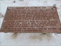
 view gallery view galleryW29.9 km |  Independence Rock - Wyoming Independence Rock - Wyoming
in Wyoming Historical Markers This location was famous along the Oregon trail as a place to inscribe your name as you passed by. Many emmigrants left home in the spring, hoping to make it to Independence Rock by July 4th, when people on the trail would gather for a party. posted by: Hikenutty location: Wyoming date approved: 07/20/2007 last visited: 09/07/2019 |
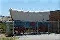 view gallery view galleryW29.9 km |  Independence Rock Wagon - Wyoming Independence Rock Wagon - Wyoming
in Covered Wagons This wagon is located at the Independence Rock State Historic Site, an important location along the Oregon Trail. posted by: Hikenutty location: Wyoming date approved: 07/20/2007 last visited: 07/24/2012 |
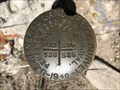
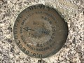
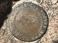
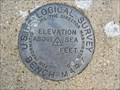
 view gallery view galleryW30.7 km |  2 PHJ - Natrona County, Wyoming 2 PHJ - Natrona County, Wyoming
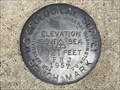
in U.S. Benchmarks A U.S. Geological Survey benchmark on the southwest side of County Road 321 (Dry Creek Road). posted by: Tom.dog location: Wyoming date approved: 05/08/2023 last visited: never |
 view gallery view gallery NE31.7 km NE31.7 km
|  First White Man's Cabin in Wyoming First White Man's Cabin in Wyoming
in First of its Kind Robert Stuart erected the first white man's cabin in Wyoming in 1812. posted by: brwhiz location: Wyoming date approved: 09/26/2012 last visited: never |
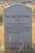
 view gallery view galleryNE31.7 km | The Oregon Trail (1841) in Wyoming Historical Markers This Historical Marker is located on the southeast side of Wyoming Highway 220 at Bessemer Bend South Road in Bessemer Bend, Wyoming. posted by: brwhiz location: Wyoming date approved: 03/22/2013 last visited: never |
 view gallery view galleryNE31.7 km | Oregon Trail (1841) in Wagon Roads and Trails This Oregon Trail Marker is located on the southeast side of Wyoming Highway 220 at Bessemer Bend South Road in Bessemer Bend, Wyoming. posted by: brwhiz location: Wyoming date approved: 10/01/2012 last visited: never |
 view gallery view galleryW31.9 km | T29N R86W S20 S21 S28 S29 - Natrona County, Wyoming in Public Land Survey Marks This GLO section corner marker is on the northwest side of Sentinel Rocks in southern Natrona County. posted by: Tom.dog location: Wyoming date approved: 05/08/2023 last visited: never |
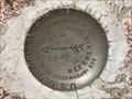
 view gallery view galleryW33.8 km | 16 PHJ - Natrona County, Wyoming in U.S. Benchmarks A USGS benchmark set to the northeast of a bend in County Road 321 (Dry Creek Road). posted by: Tom.dog location: Wyoming date approved: 05/08/2023 last visited: never |
 view gallery view gallery E34.9 km E34.9 km
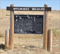
|  Interconnected to All Life Interconnected to All Life
in Flora and Fauna Information Signs This Wyoming Wildlife sign is located in the Shirley Rim Rest area on Wyoming Highway 487 south of Casper. posted by: brwhiz location: Wyoming date approved: 09/28/2012 last visited: never |
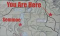 view gallery view galleryE34.9 km |  Shirley Rim Rest Area Shirley Rim Rest Area
in 'You Are Here' Maps You Are Here at the Shirley Rim Rest Area on Wyoming Highway 487 south of Casper, Wyoming. posted by: brwhiz location: Wyoming date approved: 09/24/2012 last visited: never |
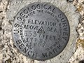
 view gallery view galleryW35.6 km | ROCKY NO 1 - Natrona County, Wyoming in U.S. Benchmarks Reference mark 1 for USGS benchmark ROCKY. posted by: Tom.dog location: Wyoming date approved: 05/08/2023 last visited: never |
 view gallery view galleryW35.6 km | ROCKY NO 2 - Natrona County, Wyoming in U.S. Benchmarks Reference mark 2 for USGS benchmark ROCKY. posted by: Tom.dog location: Wyoming date approved: 05/08/2023 last visited: never |
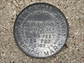
 view gallery view galleryW35.6 km | ROCKY (NR0403) - Natrona County, Wyoming in U.S. Benchmarks This U.S. Geological Survey benchmark is set near the top of an unnamed summit in the northeastern Granite Mountains. posted by: Tom.dog location: Wyoming date approved: 05/08/2023 last visited: never |
 view gallery view galleryW35.9 km | 17 PHJ - Natrona County, Wyoming in U.S. Benchmarks A U.S. Geological Survey benchmark on the south side of County Road 321/Dry Creek Road. posted by: Tom.dog location: Wyoming date approved: 05/08/2023 last visited: never |
 view gallery view galleryW37.7 km | T30N R87W S10 S11 1/4 - Natrona County, Wyoming in Public Land Survey Marks This GLO quarter corner marker is located just east of the crest of a ridge in the northeastern Granite Mountains. posted by: Tom.dog location: Wyoming date approved: 05/08/2023 last visited: never |
 view gallery view galleryW37.8 km |  Devils Gate Devils Gate
in Geological Devilish Locations Devil's Gate is a gap in the Sweetwater Rocks located southwest of Casper, WY. The coordinates are for the rest area west of the Devil's Gap. This is a place where the feature can be safely viewed. posted by: Team Min Dawg location: Wyoming date approved: 03/04/2007 last visited: 09/07/2019 |
 view gallery view gallery SE38 km SE38 km
| 3FJG USGS Shirley Basin, WY in U.S. Benchmarks Standard disc set in concrete. posted by: High-Plains-Drifter location: Wyoming date approved: 10/26/2010 last visited: 10/27/2010 |
 view gallery view galleryNE39.8 km | Emigrant Gap Historical Site in Wyoming Historical Markers The marker is located next to Poison Spider Rd., about 9 miles west of its intersection with Business U.S. Highways 20/26 in Mills, WY. Keep your eyes peeled for a small Bureau of Land Management directional sign when you arrive at the site. posted by: casperal57 location: Wyoming date approved: 01/04/2011 last visited: 05/13/2014 |
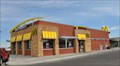 view gallery view galleryNE46 km |  McDonalds Plaza Drive McDonalds Plaza Drive
in McDonald's Restaurants This McDonalds is located at 4010 Plaza Drive in Casper, Wyoming. posted by: brwhiz location: Wyoming date approved: 07/08/2013 last visited: 03/15/2021 |
 view gallery view galleryNE46 km |  McDonalds Plaza Drive Free WiFi McDonalds Plaza Drive Free WiFi
in Wi-Fi Hotspots Free WiFi Served Daily at the McDonalds located at 4010 Plaza Drive in Casper, Wyoming. posted by: brwhiz location: Wyoming date approved: 07/03/2013 last visited: never |
 view gallery view gallerySE46.7 km | 5FJG Shirley Basin, WY in U.S. Benchmarks Standard disc set in concrete. posted by: High-Plains-Drifter location: Wyoming date approved: 10/26/2010 last visited: never |
|