 view gallery view gallery E1.3 km E1.3 km
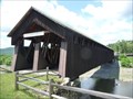
|   Old Blenheim Bridge Old Blenheim Bridge
in Wikipedia Entries Old Blenheim Bridge is a wooden covered bridge that spans Schoharie Creek in North Blenheim, New York. At 232 feet (71 m) long, it is the longest single span covered bridge in the world after the Bridgeport Covered Bridge. posted by:  nomadwillie nomadwillie location: New York date approved: 12/16/2009 last visited: 06/14/2018 |
 view gallery view galleryE1.3 km |  Old Blenheim Bridge - North Blenheim, NY Old Blenheim Bridge - North Blenheim, NY
in U.S. National Register of Historic Places Old Blenheim Bridge is a wooden covered bridge that spans Schoharie Creek in North Blenheim, New York. At 232 feet (71 m) long, it is the longest single span covered bridge in the world after the Bridgeport Covered Bridge. posted by: nomadwillie location: New York date approved: 06/29/2009 last visited: 06/14/2018 |
 view gallery view galleryE1.3 km |  Old Blenheim Bridge - North Blenheim NY Old Blenheim Bridge - North Blenheim NY
in Engineering Landmarks Old Blenheim Bridge is a wooden covered bridge that spans Schoharie Creek in North Blenheim, New York. At 232 feet (71 m) long, it is the longest single span covered bridge in the world after the Bridgeport Covered Bridge posted by: nomadwillie location: New York date approved: 06/29/2009 last visited: 06/14/2018 |
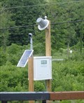 view gallery view galleryE1.3 km |  Schoharie Creek at North Blenheim - North Blenheim, NY Schoharie Creek at North Blenheim - North Blenheim, NY
in River Gauges This station was along NY route 30 at North Blenheim. posted by: ripraff location: New York date approved: 08/20/2018 last visited: never |
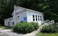 view gallery view galleryE1.3 km |  #3 Bridge Schoolhouse - North Blenheim, NY #3 Bridge Schoolhouse - North Blenheim, NY
in One-Room Schoolhouses The school was being used as a field office for rebuilding the covered bridge across the street. posted by: ripraff location: New York date approved: 09/09/2018 last visited: never |
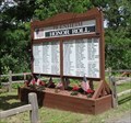 view gallery view galleryE1.3 km |  Blenheim Honor Roll - North Blenheim, NY Blenheim Honor Roll - North Blenheim, NY
in Non-Specific Veteran Memorials This memorial is by the Blenheim Covered Bridge. posted by: ripraff location: New York date approved: 08/20/2018 last visited: never |
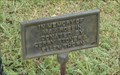
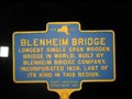 view gallery view galleryE1.3 km |  Blenheim Bridge Blenheim Bridge
in New York Historical Markers Blenheim Bridge NY Historical Marker located on Rt. 30 in Blenheim posted by: Team Smokey location: New York date approved: 04/07/2008 last visited: 06/14/2018 |
 view gallery view gallery S2.4 km S2.4 km
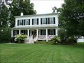
| Lansing Manor House -Blenheim NY in U.S. National Register of Historic Places The Lansing Manor House was built in 1819 by John Lansing, Jr. for his daughter and son-in-law, Jacob Livingston Sutherland. posted by: nomadwillie location: New York date approved: 06/13/2011 last visited: 08/15/2010 |
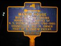 view gallery view gallery SW2.4 km SW2.4 km
| Manor House in New York Historical Markers Manor House NY Historical Marker located on Rt. 30 in Blenheim posted by: Team Smokey location: New York date approved: 04/07/2008 last visited: 06/14/2018 |
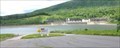
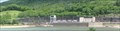 view gallery view galleryS2.9 km |  Blenheim-Gilboa Pumped Storage Power Project - Blenheim, NY, US Blenheim-Gilboa Pumped Storage Power Project - Blenheim, NY, US
in Hydroelectric Power Stations There are boat ramps to the Lower Reservoir, next to the Power Project, which is on Schoharie Creek. posted by: ripraff location: New York date approved: 08/19/2018 last visited: never |
 view gallery view galleryS3.1 km |  Ramps - Minekill State Perk, Blenheim, NY Ramps - Minekill State Perk, Blenheim, NY
in Boat Ramps The ramps are for the Blenheim-Gilboa Lower Reservoir, which is on Schoharie Creek.
"Located in the scenic Schoharie Valley, Mine Kill State Park overlooks the NY Power Authority's Blenheim-Gilboa Pumped Storage Power Project. " posted by: ripraff location: New York date approved: 08/20/2018 last visited: never |
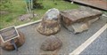
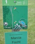 view gallery view galleryS3.5 km |  Mine Kill Park DGC - North Blenheim, NY Mine Kill Park DGC - North Blenheim, NY
in Disc Golf Courses This is the "first permanent course at a New York State Park in the Saratoga-Capital District Region." This course starts near the swimming pool on an open mowed field, it is moderately hilly. There are wooded sections. posted by: ripraff location: New York date approved: 06/20/2018 last visited: never |
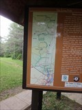
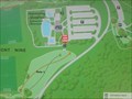 view gallery view galleryS3.5 km |  Disc Golf - Mine Kill State Park,North Blenheim, NY Disc Golf - Mine Kill State Park,North Blenheim, NY
in 'You Are Here' Maps Mine Kill Park has an 18 hole disc golf course set up in open fields near the swimming area. posted by: ripraff location: New York date approved: 06/17/2018 last visited: never |
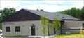 view gallery view galleryS3.9 km |  Ranger Station - Minekill State Park, North Blenheim, NY Ranger Station - Minekill State Park, North Blenheim, NY
in Ranger Stations Minekill State Park has a bluebird trail, a waterfall, and regional trail, "Long Path" running through it. One of the State Park Challenge caches was near the ranger station. posted by: ripraff location: New York date approved: 08/19/2018 last visited: never |
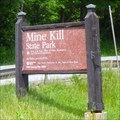 view gallery view galleryS4 km |  Mine Kill State Park - North Blenheim, NY Mine Kill State Park - North Blenheim, NY
in State/Provincial Parks Minekill State Park has a bluebird trail, a waterfall, and regional trail, "Long Path" running through it. posted by: ripraff location: New York date approved: 06/15/2018 last visited: never |
 view gallery view galleryS4 km |  The Long Path - Minekill State Park, NY The Long Path - Minekill State Park, NY
in Long Distance Hiking Trails The Long Path goes through Minekill State Park on its way from New York City to Albany, NY.
"Much of the route is through State Parks but the trail also serves as a link to smaller county and town parks. " posted by: ripraff location: New York date approved: 06/15/2018 last visited: never |
 view gallery view gallery NE4.7 km NE4.7 km
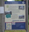
|  Town of Blenheim - North Blenheim, NY Town of Blenheim - North Blenheim, NY
in Signs of History This sign is at a fishing acres for Schoharie Creek. It is near the town line for Fulton and Blenheim Counties. The sign lists the history and attractions for Blenheim. posted by: ripraff location: New York date approved: 08/21/2018 last visited: never |
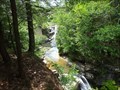 view gallery view galleryS4.7 km |  Minekill Falls - NY Minekill Falls - NY
in Waterfalls This falls is in Mine Kill State Park. The Long Path goes from the bottom to the top. posted by: ripraff location: New York date approved: 08/16/2018 last visited: never |
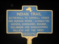 view gallery view galleryNE7.2 km | Indian Trail in New York Historical Markers Indian Trail NY Historical Marker located on Rt. 30 in Fulton posted by: Team Smokey location: New York date approved: 04/07/2008 last visited: 06/14/2018 |
 view gallery view galleryS7.6 km |  Gilboa Museum - Gilboa, NY Gilboa Museum - Gilboa, NY
in Paleontology and Fossils The Fossils are Devonian tree fossils. The world's oldest forest is the Gilboa Forest. No fee is mentioned on the website. They are only open Saturday and Sunday afternoons during the summer. There are some fossils outside. posted by: ripraff location: New York date approved: 08/21/2018 last visited: never |
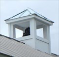 view gallery view galleryS7.6 km |  Bell tower - Gilboa, NY Bell tower - Gilboa, NY
in Bell Towers This small bell tower is on the Gilboa Museum. posted by: ripraff location: New York date approved: 08/21/2018 last visited: never |
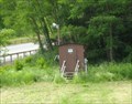
 view gallery view galleryS7.7 km |  Max Robbin - Gilboa, NY Max Robbin - Gilboa, NY
in Dedicated Trees This tree is in front of the Gilboa Museum. posted by: ripraff location: New York date approved: 08/21/2018 last visited: never |
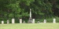 view gallery view galleryS7.7 km |  Schermerhorn-Mattice Cemetery - Gilboa, NY Schermerhorn-Mattice Cemetery - Gilboa, NY
in Worldwide Cemeteries This small cemetery is on a rise next to the bridge over Schoharie Creek at Gilboa. posted by: ripraff location: New York date approved: 08/19/2018 last visited: never |
 view gallery view galleryS7.9 km | Schoharie Creek at Gilboa Bridge - Gilboa, NY in River Gauges The gauge is near the bridge. Action stage is 15 feet, major flood 22. Yesterday, Aug 14, 2018, it was 18.33 in the minor flooding stage. Schoharie Creek flows into the Mohawk River. posted by: ripraff location: New York date approved: 08/16/2018 last visited: never |
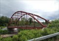 view gallery view galleryS7.9 km |  Gilboa Bridge - Gilboa, NY Gilboa Bridge - Gilboa, NY
in Arch Bridges This is a steel through arch bridge over Schoharie Creek on NY 990V. posted by: ripraff location: New York date approved: 06/15/2018 last visited: never |
|