 view gallery view gallery NW0.2 km NW0.2 km
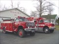
|   Tri-Village Volunteer Fire Company Tri-Village Volunteer Fire Company
in Firehouses The Tri-Village Volunteer Fire Company. posted by:  rescue557 rescue557 location: New York date approved: 12/26/2005 last visited: never |
 view gallery view gallery E6.4 km E6.4 km
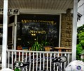
|  Medusa General Store - Medusa, NY Medusa General Store - Medusa, NY
in The Local Neighborhood Grocer Located in the town of Medusa, this store serves a local community of less than 400. posted by: nomadwillie location: New York date approved: 06/04/2013 last visited: never |
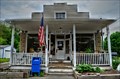 view gallery view galleryE6.4 km |  Medusa, NY 12120 Medusa, NY 12120
in U.S. Post Offices Located at 6 Red Barn Lane in Medusa NY. posted by: nomadwillie location: New York date approved: 06/08/2013 last visited: never |
  SE12.6 km SE12.6 km
| East Durham Volunteer Fire Company in Firehouses The East Durham Volunteer Fire Company. posted by: rescue557 location: New York date approved: 12/26/2005 last visited: never |
 view gallery view gallery SW17.9 km SW17.9 km
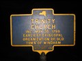
|  Trinity Church Trinity Church
in New York Historical Markers Trinity Church NY Historical Marker located on Rt. 23 in Ashland posted by: Team Smokey location: New York date approved: 04/08/2008 last visited: never |
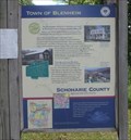 view gallery view gallery W18.3 km W18.3 km
|  Town of Blenheim - North Blenheim, NY Town of Blenheim - North Blenheim, NY
in Signs of History This sign is at a fishing acres for Schoharie Creek. It is near the town line for Fulton and Blenheim Counties. The sign lists the history and attractions for Blenheim. posted by: ripraff location: New York date approved: 08/21/2018 last visited: never |
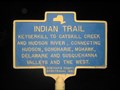 view gallery view galleryNW18.8 km | Indian Trail in New York Historical Markers Indian Trail NY Historical Marker located on Rt. 30 in Fulton posted by: Team Smokey location: New York date approved: 04/07/2008 last visited: 06/14/2018 |
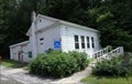 view gallery view galleryW19.3 km |  #3 Bridge Schoolhouse - North Blenheim, NY #3 Bridge Schoolhouse - North Blenheim, NY
in One-Room Schoolhouses The school was being used as a field office for rebuilding the covered bridge across the street. posted by: ripraff location: New York date approved: 09/09/2018 last visited: never |
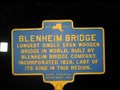
 view gallery view galleryW19.3 km |  Old Blenheim Bridge Old Blenheim Bridge
in Wikipedia Entries Old Blenheim Bridge is a wooden covered bridge that spans Schoharie Creek in North Blenheim, New York. At 232 feet (71 m) long, it is the longest single span covered bridge in the world after the Bridgeport Covered Bridge. posted by: nomadwillie location: New York date approved: 12/16/2009 last visited: 06/14/2018 |
 view gallery view galleryW19.3 km |  Old Blenheim Bridge - North Blenheim, NY Old Blenheim Bridge - North Blenheim, NY
in U.S. National Register of Historic Places Old Blenheim Bridge is a wooden covered bridge that spans Schoharie Creek in North Blenheim, New York. At 232 feet (71 m) long, it is the longest single span covered bridge in the world after the Bridgeport Covered Bridge. posted by: nomadwillie location: New York date approved: 06/29/2009 last visited: 06/14/2018 |
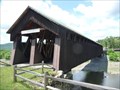 view gallery view galleryW19.3 km |  Old Blenheim Bridge - North Blenheim NY Old Blenheim Bridge - North Blenheim NY
in Engineering Landmarks Old Blenheim Bridge is a wooden covered bridge that spans Schoharie Creek in North Blenheim, New York. At 232 feet (71 m) long, it is the longest single span covered bridge in the world after the Bridgeport Covered Bridge posted by: nomadwillie location: New York date approved: 06/29/2009 last visited: 06/14/2018 |
 view gallery view galleryW19.3 km | Blenheim Bridge in New York Historical Markers Blenheim Bridge NY Historical Marker located on Rt. 30 in Blenheim posted by: Team Smokey location: New York date approved: 04/07/2008 last visited: 06/14/2018 |
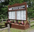 view gallery view galleryW19.3 km |  Blenheim Honor Roll - North Blenheim, NY Blenheim Honor Roll - North Blenheim, NY
in Non-Specific Veteran Memorials This memorial is by the Blenheim Covered Bridge. posted by: ripraff location: New York date approved: 08/20/2018 last visited: never |
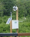 view gallery view galleryW19.3 km |  Schoharie Creek at North Blenheim - North Blenheim, NY Schoharie Creek at North Blenheim - North Blenheim, NY
in River Gauges This station was along NY route 30 at North Blenheim. posted by: ripraff location: New York date approved: 08/20/2018 last visited: never |
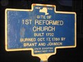 view gallery view galleryNW19.6 km | Site of 1st Reformed Church in New York Historical Markers Site of 1st Reformed Church NY Historical Marker located on Rt. 145 in Middleburgh posted by: Team Smokey location: New York date approved: 04/06/2008 last visited: never |
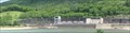 view gallery view galleryW19.8 km |  Blenheim-Gilboa Pumped Storage Power Project - Blenheim, NY, US Blenheim-Gilboa Pumped Storage Power Project - Blenheim, NY, US
in Hydroelectric Power Stations There are boat ramps to the Lower Reservoir, next to the Power Project, which is on Schoharie Creek. posted by: ripraff location: New York date approved: 08/19/2018 last visited: never |
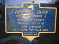 view gallery view galleryNW19.8 km | Weiser's Dorf in New York Historical Markers Weiser's Dorf NY Historical Marker located on Rt. 145 in Middleburgh posted by: Team Smokey location: New York date approved: 04/06/2008 last visited: never |
 view gallery view galleryNW20 km | Indian Village in New York Historical Markers Indian Village NY Historical Marker located on Rt. 30 in Middleburgh posted by: Team Smokey location: New York date approved: 04/07/2008 last visited: 09/20/2012 |
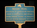 view gallery view galleryNW20.1 km | Indian Trail in New York Historical Markers Indian Trail NY Historical Marker located on Rt. 30 in Fulton posted by: Team Smokey location: New York date approved: 04/07/2008 last visited: 06/14/2018 |
 view gallery view galleryNW20.1 km |  Middle Burgh - Middleburgh, NY Public Library Middle Burgh - Middleburgh, NY Public Library
in Painted Barn Quilts A quilt on the side of the library posted by:  chrissyml chrissyml location: New York date approved: 04/03/2018 last visited: never |
 view gallery view galleryNW20.1 km |  Max V. Shaul State Park - NY Max V. Shaul State Park - NY
in State/Provincial Parks Max V. Shaul is a small park that has camping. There is a great deal of construction occurring currently. posted by: ripraff location: New York date approved: 06/15/2018 last visited: never |
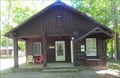 view gallery view galleryNW20.1 km |  Park Office - Max V. Shaul State Park, NY Park Office - Max V. Shaul State Park, NY
in Ranger Stations This Park Office doubles as a nature center. It is at the entrance to Max V. Shaul State Park. posted by: ripraff location: New York date approved: 08/19/2018 last visited: never |
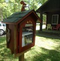 view gallery view galleryNW20.1 km |  LFL 52011 - Max Shaul Park - NY LFL 52011 - Max Shaul Park - NY
in Free Community Book Exchanges This Little Free Library is in front of the park ranger's office, near the entrance to the park. posted by: ripraff location: New York date approved: 06/15/2018 last visited: never |
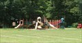 view gallery view galleryNW20.1 km |  Playground - Max V. Shaul State Park, Fulton, New York Playground - Max V. Shaul State Park, Fulton, New York
in Public Playgrounds This is a large modern playground near the park entrance. There is a nearby restroom and picnic tables. posted by: ripraff location: New York date approved: 08/10/2021 last visited: never |
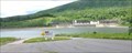 view gallery view galleryW20.1 km |  Ramps - Minekill State Perk, Blenheim, NY Ramps - Minekill State Perk, Blenheim, NY
in Boat Ramps The ramps are for the Blenheim-Gilboa Lower Reservoir, which is on Schoharie Creek.
"Located in the scenic Schoharie Valley, Mine Kill State Park overlooks the NY Power Authority's Blenheim-Gilboa Pumped Storage Power Project. " posted by: ripraff location: New York date approved: 08/20/2018 last visited: never |
|