 view gallery view gallery W21.1 km W21.1 km
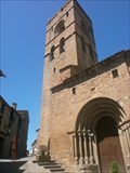
|   Iglesia-colegiata de la Asunción de Nuestra Señora. Ainsa. Spain Iglesia-colegiata de la Asunción de Nuestra Señora. Ainsa. Spain
in Spanish Heritage Iglesia-colegiata de la Asunción de Nuestra Señora posted by:  lulu_et_compagnie lulu_et_compagnie location: Aragón, Spain date approved: 09/15/2015 last visited: 11/29/2022 |
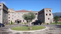 view gallery view galleryW26.6 km |  Barceló Monasterio de Boltaña, Boltana, Huesca, Spain Barceló Monasterio de Boltaña, Boltana, Huesca, Spain
in Antique Hotels A wonderful hotel to relax and a fine spot to explore the surroundings. posted by: g300td location: Aragón, Spain date approved: 01/16/2015 last visited: never |
 view gallery view gallery NE35.9 km NE35.9 km
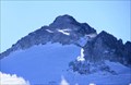
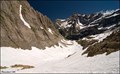
|  Pico Aneto - Highest Point of "Pirineus" Pico Aneto - Highest Point of "Pirineus"
in Geographic High Points El Aneto es el pico más elevado de los Pirineos, con una altitud de 3.404 metros sobre el nivel del mar. posted by:  Galleda Galleda location: Spain date approved: 10/13/2008 last visited: never |
 view gallery view gallery N41 km N41 km
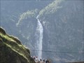
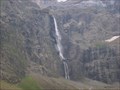
|  Cascade d’Oô - Oô - Haute-Garonne, Pyrenees - France Cascade d’Oô - Oô - Haute-Garonne, Pyrenees - France
in Waterfalls Cascade d’Oô posted by: CADS11 location: Occitanie, France date approved: 11/16/2016 last visited: 08/28/2022 |
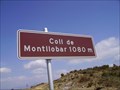 view gallery view gallery SE41.5 km SE41.5 km
| Coll de Montllobar in Geographic High Points Alto en la carretera C-1131 entre las localidades de Tremp y Barbastro. posted by: Liderskull1 location: Cataluña, Spain date approved: 11/17/2009 last visited: 11/17/2009 |
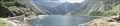 view gallery view galleryN41.7 km |  Lac dOo - Oô - Haute-Garonne, Pyrenees - France Lac dOo - Oô - Haute-Garonne, Pyrenees - France
in Water Dams Lac dOo posted by: CADS11 location: Occitanie, France date approved: 11/17/2016 last visited: 08/28/2022 |
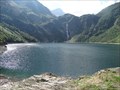 view gallery view galleryN41.7 km |  Lac dOo - Oô - Haute-Garonne, Pyrenees - France Lac dOo - Oô - Haute-Garonne, Pyrenees - France
in Wikipedia Entries Lac dOo posted by: CADS11 location: Occitanie, France date approved: 11/16/2016 last visited: 08/28/2022 |
 view gallery view galleryNE43.1 km |  Pic de Comaloforno (3029.18m) Pic de Comaloforno (3029.18m)
in Vértices Geodésicos Pic de Comaloforno, 3029.18m, sostre comarcal de l'Alta Ribagorça.
[ENG] Comaloforno peak, 3029.18m, Alta Ribagorça's county summit. posted by: SastRe.O location: Cataluña, Spain date approved: 03/15/2017 last visited: never |
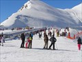
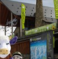 view gallery view galleryN44.3 km |  Formigal - Arágon, Spain Formigal - Arágon, Spain
in Winter Sports Locations Formigal, officially called Aramón Formigal, is a ski resort situated near the town of Sallent de Gallego in the upper Tena Valley of the western Pyrenees (province of Huesca, Spain). posted by: tmob location: Aragón, Spain date approved: 03/23/2011 last visited: never |
 view gallery view gallery NW46 km NW46 km
|  Pyrénées - Mont Perdu (France) Pyrénées - Mont Perdu (France)
in World Heritage Sites Stunning mountain landscape, which spans the contemporary national borders of France and Spain, centered around the peak of Mt. Perdu is one from the jewels of Nature in the European context... posted by: Dorcadion Team location: Occitanie, France date approved: 05/28/2009 last visited: 04/29/2012 |
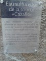 view gallery view galleryN47 km |  Source Cazalis. Loudenvieille. France Source Cazalis. Loudenvieille. France
in Hot Springs Source d'eau chaude de Cazalis posted by: lulu_et_compagnie location: Occitanie, France date approved: 03/30/2017 last visited: 03/30/2017 |
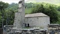 view gallery view galleryN47.6 km |  la chapelle des templiers, Aragnouet, France la chapelle des templiers, Aragnouet, France
in Legacy of Medieval Spiritual Warriors La chapelle des templiers d'Aragnouet - The chapel of the Templars of Aragnouet posted by: celene37 location: Occitanie, France date approved: 02/23/2018 last visited: 02/23/2018 |
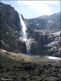 view gallery view galleryNW48 km | Le Grande Cascade de Gavarnie / The Gavarnie Falls (Hautes-Pyrénées, France) in Waterfalls Le Grande Cascade de Gavarnie (The Gavarnie Falls) is a tiered waterfall and with overall drop of 422 m is the tallest waterfall in France. The falls are situated in Cirque de Gavarnie, close to the village Gavarnie in the Pyrénées Mts. posted by: Dorcadion Team location: Occitanie, France date approved: 05/04/2009 last visited: 08/28/2022 |
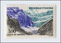 view gallery view galleryNW48.6 km |  Cirque de Gavarnie (France) Cirque de Gavarnie (France)
in Philatelic Photographs This French stamp depicts the most impressive natural amphitheatre in Europe - Cirque de Gavarnie in the Pyrenees National Park. posted by: Dorcadion Team location: Occitanie, France date approved: 03/25/2010 last visited: 08/28/2022 |
 view gallery view galleryNW48.8 km | Cirque de Gavarnie - France in Glaciers Cirque de Gavarnie posted by: lulu_et_compagnie location: Occitanie, France date approved: 11/25/2018 last visited: 08/28/2022 |
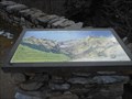
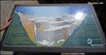 view gallery view galleryNW48.9 km |  Cirque de Gavarnie Orientation Panel (Pyrenees Mts., France) Cirque de Gavarnie Orientation Panel (Pyrenees Mts., France)
in Orientation Tables Close to the entrance to the magnificent Cirque de Gavarnie (Cirque is amphitheatre-like valley) in Pyrenees Mts. you can find the orientation panel depicting and describing the Cirque... posted by: Dorcadion Team location: Occitanie, France date approved: 09/09/2009 last visited: 08/28/2022 |
 view gallery view galleryNW48.9 km | la table d'orientation du cirque de Gavarnie - Midi-Pyrénées, France in Orientation Tables En faisait la randonnée pour aller voir le cirque de Gavarnie, vous pourrez voir cette table d'orientation, juste à côté du café restaurant hôtel du cirque et de la cascade. posted by: Emeraude37 location: Occitanie, France date approved: 02/23/2016 last visited: 08/28/2022 |
 view gallery view galleryN48.9 km |  Centrale Hydroelectrique - Saint Lary Soulan, France Centrale Hydroelectrique - Saint Lary Soulan, France
in Official Local Tourism Attractions The visit is managed by the tourist office on the site of the EDF power station.
La visite est géré par l'office de tourisme sur le site de la centrale EDF. posted by: sara et gege location: Occitanie, France date approved: 01/12/2021 last visited: 10/28/2021 |
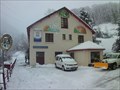
 view gallery view galleryN48.9 km |  usine Saint Lary Soulan, France usine Saint Lary Soulan, France
in Hydroelectric Power Stations The visit is managed by the tourist office on the site of the EDF power station. La visite est géré par l'office de tourisme sur le site de la centrale EDF. posted by: sara et gege location: Occitanie, France date approved: 01/12/2021 last visited: 10/28/2021 |
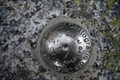
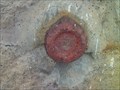 view gallery view galleryN48.9 km |  Benchmark Centrale Hydroelectrique - Saint Lary Soulan, France Benchmark Centrale Hydroelectrique - Saint Lary Soulan, France
in French Benchmarks sur le mur dans l'angle posted by: sara et gege location: Occitanie, France date approved: 01/12/2021 last visited: 11/03/2021 |
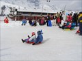 view gallery view galleryN49.1 km |  Plan de glisse - Saint Lary,Fr Plan de glisse - Saint Lary,Fr
in Sledding Places the toboggan run the resort of Saint Lary 1700
la piste de luge de la station de Saint Lary 1700 posted by: sara et gege location: Nouvelle-Aquitaine, France date approved: 12/01/2014 last visited: 03/04/2018 |
 view gallery view galleryN49.1 km |  Pic de Lumiere 1650 - Saitn Lary, France Pic de Lumiere 1650 - Saitn Lary, France
in Elevation Signs the Pic Lumiere gave its name to the cable car.
le Pic Lumiere a donné sont nom au telecabine. posted by: sara et gege location: Occitanie, France date approved: 12/29/2020 last visited: 09/03/2021 |
 view gallery view galleryN49.1 km | Station Saint Lary 1700 - Saint Lary Soulan,Fr in Winter Sports Locations Saint-Lary 1700 (Pla d'Adet) offers a panorama of the Pyrenees.
Saint-lary 1700 (Pla d’Adet) offre un panorama grandiose sur la chaîne des Pyrénées. posted by: sara et gege location: Occitanie, France date approved: 09/03/2014 last visited: 03/04/2018 |
 view gallery view galleryN49.1 km |  Mairie Plat d'Adet , France Mairie Plat d'Adet , France
in City and Town Halls The town city hall is at the arrival house of the cable car.
Le mairie est dans la maison d'arrivée du telephérique. posted by: sara et gege location: Occitanie, France date approved: 01/01/2021 last visited: 09/03/2021 |
 view gallery view galleryN49.1 km |  Office de Tourisme du plat d'Adet, France Office de Tourisme du plat d'Adet, France
in Tourist Information Centers - Visitor Centers The post office is at the arrival house of the cable car.
Le bureau de poste est dans la maison d'arrivée du telephérique. posted by: sara et gege location: Occitanie, France date approved: 12/31/2020 last visited: 09/03/2021 |
|