 view gallery view gallery N30.4 km N30.4 km
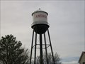
|   Watertower, Ainsworth, Nebraska Watertower, Ainsworth, Nebraska
in Water Towers Older watertower in the western part of town. Elevation 2516. posted by:  NGComets NGComets location: Nebraska date approved: 12/06/2017 last visited: never |
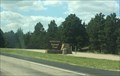
 view gallery view galleryN33.6 km |  Ainsworth Army Air Field Ainsworth Army Air Field
in Nebraska Historical Markers One of eleven training bases in Nebraska during World War II. posted by: plainsdrifter358 location: Nebraska date approved: 05/11/2008 last visited: 07/27/2009 |
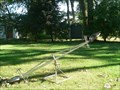
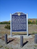
 view gallery view galleryN34 km | Lakeland Sod High School in Nebraska Historical Markers Nebraska prairie sod is used to build a High School in 1924. posted by: plainsdrifter358 location: Nebraska date approved: 06/02/2008 last visited: 05/08/2008 |
 view gallery view gallery S37.7 km S37.7 km
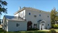
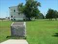
|  Blaine County Courthouse, Brewster, NE Blaine County Courthouse, Brewster, NE
in Courthouses This white stucco sided Courthouse was built in 1908 to replace an earlier structure. posted by:  NevaP NevaP location: Nebraska date approved: 10/13/2008 last visited: never |
 view gallery view gallery NE43 km NE43 km
|  Ghet Stockwell Bandshell - Bassett, Nebraska Ghet Stockwell Bandshell - Bassett, Nebraska
in Bandshells This is the Ghet Stockwell Bandshell in Bassett, Nebraska on route 20. It was sponsored by the Lions club and built in 1954. posted by: Mountain_Wanderer location: Nebraska date approved: 09/16/2008 last visited: never |
 view gallery view gallery SE44.7 km SE44.7 km
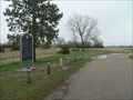
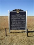
| Harrop # 375 in Nebraska Historical Markers Harrop Nebraska State Historical Marker posted by:  Biker Ozzy Biker Ozzy location: Nebraska date approved: 06/17/2008 last visited: 03/13/2011 |
 view gallery view gallery SW54.4 km SW54.4 km
|  Nebraska National Forest (Bessey Ranger District) Nebraska National Forest (Bessey Ranger District)
in Public Access Lands A national forest in the center of Nebraska, featuring one of the largest hand-planted forests in the world. posted by: Zaphody3k location: Nebraska date approved: 10/14/2014 last visited: 06/27/2014 |
 view gallery view galleryNE55.8 km |  First Roadside Rest Area in Nebraska First Roadside Rest Area in Nebraska
in First of its Kind On this site about 1938, Vic and Maude Thompson established what is considered to be the first roadside rest area in Nebraska. posted by: plainsdrifter358 location: Nebraska date approved: 03/21/2007 last visited: 08/02/2006 |
 view gallery view galleryNE55.8 km | Spring Valley Park in Nebraska Historical Markers Newport, NE, established in 1883, became one of the major hay shipping centers in the Nation. Pioneers of eastern Rock County recognized Spring Valley as a great natural haying region extending over twenty miles south down this valley. posted by: plainsdrifter358 location: Nebraska date approved: 03/21/2007 last visited: 05/03/2009 |
 view gallery view galleryN61.8 km | Keya Paha County Centennial 1885 ~ 1985 in Nebraska Historical Markers Keya Paha County was organized in 1885 was created from that part of Brown County lying north of the Niobrara River. posted by: plainsdrifter358 location: Nebraska date approved: 03/21/2007 last visited: 08/02/2006 |
 view gallery view galleryN61.8 km |  Keya Paha County High School Keya Paha County High School
in U.S. National Register of Historic Places First Keya Paha County High School Building in operation from 1916 to 1965. posted by: plainsdrifter358 location: Nebraska date approved: 03/21/2007 last visited: 08/02/2006 |
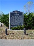 view gallery view gallerySE62.1 km | Valleyview # 320 in Nebraska Historical Markers Marker about an old town, no longer around. posted by: Biker Ozzy location: Nebraska date approved: 05/01/2009 last visited: never |
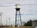 view gallery view galleryN62.1 km | Watertower, Springview, Nebraska in Water Towers Small town watertower. Elevation 2449. posted by: NGComets location: Nebraska date approved: 12/06/2017 last visited: never |
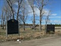
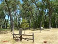
 view gallery view galleryN63.1 km |  Mt. Hope Cemetery, Springview, Nebraska Mt. Hope Cemetery, Springview, Nebraska
in Worldwide Cemeteries Located just south of Springview, NE, along US Hwy 385.
Elevation 2427. posted by: NGComets location: Nebraska date approved: 12/13/2017 last visited: never |
 view gallery view gallerySW64.2 km | Sandhills in Nebraska Historical Markers Sand dunes covering neary 25% of Nebraska are scenic and topographically unique. Cattlemen began commercial grazing operations in the 1870s. posted by: plainsdrifter358 location: Nebraska date approved: 05/11/2008 last visited: 04/11/2023 |
 view gallery view gallerySE66.1 km | The Calumus Valley # 307 in Nebraska Historical Markers Nebraska State Historical Marker. posted by: Biker Ozzy location: Nebraska date approved: 05/01/2009 last visited: never |
 view gallery view galleryN66.1 km | Homestead of David and Kate Clopton in Nebraska Historical Markers This is a settlement success story resulting from the Homestead Act of 1862 and the Timber Culture Act of 1873. posted by: plainsdrifter358 location: Nebraska date approved: 03/21/2007 last visited: 08/02/2006 |
 view gallery view gallerySW67.1 km | Thomas County Courthouse, Thedford, NE in Courthouses Built in 2006, this is one of the newest courthouses in Nebraska. posted by: NevaP location: Nebraska date approved: 09/08/2008 last visited: never |
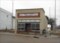 view gallery view gallerySE69 km |  Taylor NE 68879 Taylor NE 68879
in U.S. Post Offices This Post Office is on Murray St at Hwy 183 (3rd St) in Taylor, Nebraska. posted by: PeterNoG location: Nebraska date approved: 04/27/2011 last visited: 03/13/2011 |
 view gallery view gallerySE73.1 km | The North Loup Project # 326 in Nebraska Historical Markers Nebaraska State Historical Marker. posted by: Biker Ozzy location: Nebraska date approved: 05/01/2009 last visited: never |
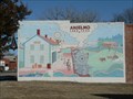 view gallery view galleryS73.1 km |  Centenial of Rural Life and Times in Anselmo, NE Centenial of Rural Life and Times in Anselmo, NE
in Murals Centenial depiction of rural happenings in and around Anselmo, NE (current pop. 159). posted by: plainsdrifter358 location: Nebraska date approved: 03/06/2006 last visited: 04/08/2023 |
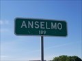 view gallery view galleryS73.5 km |  Anselmo, NE - Population 189 Anselmo, NE - Population 189
in Population Signs Anselmo, NE, population 189 as of this posting. This sign is located on the north side of NE 2 at the southern village limit. posted by: QuarrellaDeVil location: Nebraska date approved: 09/08/2020 last visited: never |
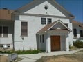
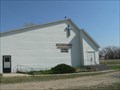 view gallery view galleryN74.2 km |  Grace Lutheran - SD Grace Lutheran - SD
in Country Churches Grace Lutheran Church in the Ghost Town of Burton, NE posted by: plainsdrifter358 location: Nebraska date approved: 05/12/2008 last visited: 04/30/2008 |
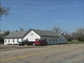 view gallery view galleryN74.2 km | Burton First Assembly of God Church - NE in Country Churches Burton Assembly of God church located in a small ghost town of Burton, NE. posted by: plainsdrifter358 location: Nebraska date approved: 05/12/2008 last visited: 04/30/2008 |
 view gallery view gallery NW77.4 km NW77.4 km
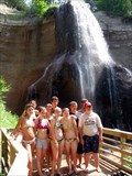
|  Smith Falls Smith Falls
in Waterfalls Waterfalls in Nebraska? Yes, there really are some and Smith Falls is the tallest. It's easily accessible on foot when either parking at the Visitor Center, the campground or when canoeing down the Niobrara River. The walkway to the falls is also wheelchair accessible, so everyone can enjoy the beauty of nature in this park. posted by: DakotaGeek location: Nebraska date approved: 01/29/2006 last visited: 07/12/2009 |
|