 view gallery view gallery SE0.2 km SE0.2 km
|   McGolf Mini-Putt Waterfall - Dedham, MA McGolf Mini-Putt Waterfall - Dedham, MA
in Man-made Waterfalls This waterfall flows from the top of peak of the miniature golf course down several cascades to the pond at the base where turtles and carp swim. posted by:  NorStar NorStar location: Massachusetts date approved: 06/30/2012 last visited: never |
 view gallery view gallerySE0.2 km |  McGolf Mini-Putt - Dedham, MA McGolf Mini-Putt - Dedham, MA
in Miniature Golf McGolf Mini-Putt is an 18 hole miniature golf course all over a 'mountain.' posted by: NorStar location: Massachusetts date approved: 06/26/2012 last visited: never |
 view gallery view gallery NE0.6 km NE0.6 km
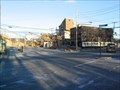
|  STATE 109 & Charles River - Boston / Dedham MA STATE 109 & Charles River - Boston / Dedham MA
in American Guide Series Tour 1D begins at the city limits of Boston and Dedham. It also the beginning of MA 109. posted by:  nomadwillie nomadwillie location: Massachusetts date approved: 02/03/2021 last visited: never |
 view gallery view gallery W0.6 km W0.6 km
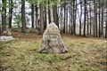
|  Pierre Pockwinse Sundial - Dedham MA USA Pierre Pockwinse Sundial - Dedham MA USA
in Sundials The Pierre Pockwinse Sundial is located in the Pine Ridge Pet Cemetery in Dedham MA. posted by: nomadwillie location: Massachusetts date approved: 04/05/2022 last visited: never |
 view gallery view galleryW0.6 km |  Grave of Igloo, Admiral Richard Byrd's Dog - Dedham MA Grave of Igloo, Admiral Richard Byrd's Dog - Dedham MA
in Roadside Attractions Igloo is the dog that discovered the South Pole with Admiral Richard Byrd accompanying him. The headstone is in the shape of an iceberg. posted by: nomadwillie location: Massachusetts date approved: 04/03/2022 last visited: never |
 view gallery view galleryW0.6 km |  Animal Rescue League of Boston, Pine Ridge Animal Center - Dedham, MA Animal Rescue League of Boston, Pine Ridge Animal Center - Dedham, MA
in Humane Societies and Rescues The Animal Rescue League has been "helping animals since 1899," and this center has an animal shelter as well as a livestock rehabilitation facility and a pet cemetery. posted by: NorStar location: Massachusetts date approved: 03/03/2010 last visited: never |
 view gallery view galleryW0.8 km |  Pine Ridge Pet Cemetery - Dedham, MA Pine Ridge Pet Cemetery - Dedham, MA
in Pet Cemeteries The Pine Ridge Pet Cemetery has two main areas: the open grassy newer area that is visible from the road, and a wooded older area that has graves dating back to the early 1900s, including a memorial to 'Igloo.' posted by: NorStar location: Massachusetts date approved: 03/06/2010 last visited: never |
 view gallery view galleryW0.8 km |  Pine Ridge Pet Cemetery Gazebo - Dedham, MA Pine Ridge Pet Cemetery Gazebo - Dedham, MA
in Gazebos The stone gazebo at the Pine Ridge Pet Cemetery overlooks a dale with stone monuments for pets that date back to the early 1900s. posted by: NorStar location: Massachusetts date approved: 03/02/2010 last visited: never |
 view gallery view gallery S1 km S1 km
|  Toy VW 'Bug', Joe's Auto Sales and Service - Dedham, MA Toy VW 'Bug', Joe's Auto Sales and Service - Dedham, MA
in Elevated Everyday Objects This toy 'bug' is on top of Joe's Auto Sales and Service, which specializes in Volkswagens. posted by: NorStar location: Massachusetts date approved: 04/30/2010 last visited: never |
 view gallery view gallerySE1.3 km |  CR-14-71 - US ACE Easement Survey Mark - Dedham, MA CR-14-71 - US ACE Easement Survey Mark - Dedham, MA
in Public Land Survey Marks This survey marker was found along the Providence Highway and marks the easement boundary around the Charles River. posted by: NorStar location: Massachusetts date approved: 03/31/2010 last visited: never |
 view gallery view gallerySE1.3 km | CR-14-87 USACE Easement Boundary Marker - Dedham, MA in Public Land Survey Marks This U.S. Army Corps of Engineers marker is one of four found along the Providence Highway and marks an easement line around the Charles River. posted by: NorStar location: Massachusetts date approved: 03/28/2010 last visited: never |
 view gallery view gallery E1.3 km E1.3 km
|  West Roxbury Crushed Stone Quarry West Roxbury Crushed Stone Quarry
in Active Quarries This quarry provides much of the stone used in many projects in the area, including the Big Dig. posted by: NorStar location: Massachusetts date approved: 03/05/2006 last visited: never |
 view gallery view gallerySE1.3 km | CR-14-21 USACE Easement Boundary Marker - Dedham, MA in Public Land Survey Marks This was one of several disks and witness posts found along the Providence Highway that marked an easement around the Charles River. posted by: NorStar location: Massachusetts date approved: 03/29/2010 last visited: never |
 view gallery view galleryS1.3 km |  Tree Enveloping Iron Fence - Dedham, MA Tree Enveloping Iron Fence - Dedham, MA
in Omnivorous Trees This tree wants to become ironwood. posted by: NorStar location: Massachusetts date approved: 02/07/2012 last visited: never |
 view gallery view galleryS1.4 km | Mother Brook - Dedham, MA in American Guide Series Mother Brook, one of the earliest canals dug in America, connected the Charles River with the Neponset River 'before 1640,' and was the basis of industry in Dedham (and the Hyde Park section of Boston). posted by: NorStar location: Massachusetts date approved: 03/06/2012 last visited: never |
 view gallery view gallerySE1.4 km |  LOOM Family Center 189 - Dedham, MA LOOM Family Center 189 - Dedham, MA
in Moose Lodges and Centers The Dedham Chapter is located on a side road and has a family center. posted by: NorStar location: Massachusetts date approved: 03/26/2010 last visited: never |
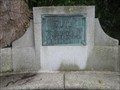 view gallery view galleryS1.6 km |  Dedham "Keye" Landing Place - Dedham, MA Dedham "Keye" Landing Place - Dedham, MA
in Massachusetts Historical Markers This place along the Charles River, and along today's Ames Street Bridge, is considered the location where the first settlers landed and founded Dedham, MA, in 1636. posted by: NorStar location: Massachusetts date approved: 04/24/2008 last visited: never |
 view gallery view galleryW1.6 km |  D-N2 WM - Dedham - Needham Witness Mark, at Charles River - Norfolk County, MA D-N2 WM - Dedham - Needham Witness Mark, at Charles River - Norfolk County, MA
in U.S. Historic Survey Stones and Monuments This witness mark stands on the location where the Needham-Dedham line leaves the Charles River, temporarily, and heads across the Great Plain Marsh back to the river. posted by: NorStar location: Massachusetts date approved: 02/06/2013 last visited: never |
 view gallery view gallerySE1.6 km |  USGS River Gauge Station #01104000 on Mother Brook in Dedham, MA USGS River Gauge Station #01104000 on Mother Brook in Dedham, MA
in River Gauges This USGS gauge is located off the Washington Street Bridge in Dedham, MA, along Mother Brook. posted by: NorStar location: Massachusetts date approved: 04/22/2008 last visited: never |
 view gallery view galleryS1.6 km | CR-14-12, US ACE Easement Boundary Survey Mark - Dedham, MA in Public Land Survey Marks This marker was one of four found along Providence Highway that marks an easement boundary around the Charles River. posted by: NorStar location: Massachusetts date approved: 03/28/2010 last visited: never |
 view gallery view gallery N1.8 km N1.8 km
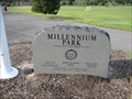
|  Millennium Park - Boston, MA Millennium Park - Boston, MA
in Made for the Millennium Millennium Park, run by the Boston Parks and Recreation and dedicated in the year 2000, is a multi-use park with fields at the top of the large "mound", hiking trails, and a canoe launch area. posted by: NorStar location: Massachusetts date approved: 08/27/2010 last visited: never |
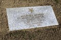 view gallery view gallerySE1.8 km |  Michael DeNeff-Dedham, MA Michael DeNeff-Dedham, MA
in Medal Of Honor Resting Places Peacetime Medal of Honor Recipient for action on board the USS Swatara at Para, Brazil on December 1, 1875. He is buried in Brookdale Cemetery, Dedham, MA in the Brookdale Section, Lot 1355F, Grave 85. posted by: Don.Morfe location: Massachusetts date approved: 03/29/2018 last visited: 12/15/2021 |
 view gallery view galleryW1.9 km |  Disk MY5404, 10929 - Needham, MA Disk MY5404, 10929 - Needham, MA
in U.S. Benchmarks This survey disk is located to the east of the Great Plain Avenue Bridge over I-95/Route 128, behind the guard rail. posted by: NorStar location: Massachusetts date approved: 03/21/2010 last visited: never |
 view gallery view galleryS1.9 km |  Allin Congregational Church Tower - Dedham, MA Allin Congregational Church Tower - Dedham, MA
in Bell Towers A bell is still visible in the tower of Allin Church. posted by: NorStar location: Massachusetts date approved: 08/10/2016 last visited: never |
 view gallery view galleryS1.9 km |  Allin Congregational Church - Dedham, MA Allin Congregational Church - Dedham, MA
in Continental Reformed and Congregational Church Sites Allin Congregational Church has its roots with the Puritans that settled here in 1638. posted by: NorStar location: Massachusetts date approved: 08/05/2016 last visited: never |
|