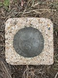
 view gallery view gallery SE42.3 km SE42.3 km
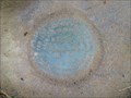
|   10 WWC (MO0374) - Platte County, Wyoming 10 WWC (MO0374) - Platte County, Wyoming
in U.S. Benchmarks This USGS benchmark can be found a short ways to the north of State Highway 34. posted by:  Tom.dog Tom.dog location: Wyoming date approved: 12/09/2022 last visited: never |
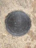 view gallery view gallerySE42.3 km | N 166 RESET (MO1339) - Platte County, Wyoming in U.S. Benchmarks An NGS vertical control mark on the west side of State Highway 34. posted by: Tom.dog location: Wyoming date approved: 12/09/2022 last visited: never |
 view gallery view gallerySE44.1 km | P 166 RESET (AH7389) - Platte County, Wyoming in U.S. Benchmarks An NGS vertical control disk on the northwest side of State Highway 34. posted by: Tom.dog location: Wyoming date approved: 06/11/2023 last visited: never |
 view gallery view gallery S46 km S46 km
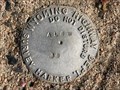
| ALBW 38 - Albany County, Wyoming in U.S. Benchmarks A Wyoming Highway Department survey marker near an abandoned section of highway grade. posted by: Tom.dog location: Wyoming date approved: 08/13/2023 last visited: never |
 view gallery view gallery SW47.2 km SW47.2 km
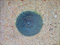
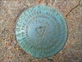
| U 321 (MO0730) - Albany County, Wyoming in U.S. Benchmarks A benchmark disk to the west of US 30/287. posted by: Tom.dog location: Wyoming date approved: 11/21/2022 last visited: never |
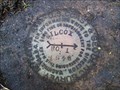
 view gallery view gallerySW47.2 km | WILCOX NO 2 - Albany County, Wyoming in U.S. Benchmarks Reference mark 2 for triangulation station WILCOX. posted by: Tom.dog location: Wyoming date approved: 11/21/2022 last visited: never |
 view gallery view gallerySW47.2 km | WILCOX (MO0969) - Albany County, Wyoming in U.S. Benchmarks A triangulation station on the west side of U.S. 30/287, about 3.5 miles north of Rock River. posted by: Tom.dog location: Wyoming date approved: 11/21/2022 last visited: never |
 view gallery view gallerySW47.2 km | WILCOX NO 1 - Albany County, Wyoming in U.S. Benchmarks Reference mark 1 for triangulation station Wilcox, located on the west side of US 30/287. posted by: Tom.dog location: Wyoming date approved: 11/21/2022 last visited: never |
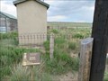
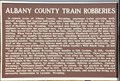 view gallery view gallerySW47.2 km |  Albany County Train Robberies Albany County Train Robberies
in Wyoming Historical Markers This Wyoming Historical Marker is one of two at the same location on the north side of US Highway 30/287 at Como Bluffs between Medicine Bow and Rock River. posted by: brwhiz location: Wyoming date approved: 09/25/2012 last visited: 08/07/2023 |
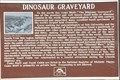 view gallery view gallerySW47.2 km | Dinosaur Graveyard in Wyoming Historical Markers This Wyoming Historical Marker is the second of two at the same location on the north side of US Highway 30/287 at Como Bluffs between Medicine Bow and Rock River. posted by: brwhiz location: Wyoming date approved: 09/25/2012 last visited: 08/07/2023 |
 view gallery view gallerySW47.2 km |  Como Bluff – Rock River, WY Como Bluff – Rock River, WY
in U.S. National Register of Historic Places Como Bluff is the home of the largest dinosaur fossil beds in the world. posted by:  wildernessmama wildernessmama location: Wyoming date approved: 01/07/2018 last visited: 08/07/2023 |
 view gallery view gallerySW47.2 km | Fossil Cabin - Medicine Bow, WY in U.S. National Register of Historic Places Located on the Lincoln Hwy a few miles east of Medicine Bow, the unique Fossil Cabin was constructed from dinosaur bones. posted by: wildernessmama location: Wyoming date approved: 01/07/2018 last visited: 08/07/2023 |
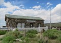
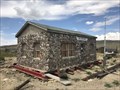 view gallery view gallerySW47.2 km |  Fossil Cabin at Como Bluff - Medicine Bow, Wyoming Fossil Cabin at Como Bluff - Medicine Bow, Wyoming
in Paleontology and Fossils The Fossil Cabin was built in 1932; its exterior walls are built entirely with fossilized dinosaur bones from the nearby Como Bluff fossil bed. posted by: Tom.dog location: Wyoming date approved: 08/13/2023 last visited: never |
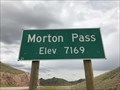 view gallery view galleryS48.1 km |  Morton Pass, Albany County, Wyoming - 7,169' Morton Pass, Albany County, Wyoming - 7,169'
in Elevation Signs The summit of Morton Pass is marked by two signs on either side of State Highway 34 that display the elevation of the pass. posted by: Tom.dog location: Wyoming date approved: 08/11/2023 last visited: never |
 view gallery view gallery W48.9 km W48.9 km
| 6 HA (MP0045) - Carbon County, Wyoming in U.S. Benchmarks A USGS Benchmark to the northeast of State Highway 487. posted by: Tom.dog location: Wyoming date approved: 08/13/2023 last visited: never |
 view gallery view galleryW49.7 km | 4 HA (MP0043) - Carbon County, Wyoming in U.S. Benchmarks This USGS benchmark is set along the top of a low ridge to the west of State Highway 487. posted by: Tom.dog location: Wyoming date approved: 08/13/2023 last visited: never |
 view gallery view gallery E50.2 km E50.2 km
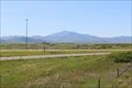
|  Laramie Peak - Dwyer Junction, WY Laramie Peak - Dwyer Junction, WY
in Scenic Roadside Look-Outs A pretty nice view of Laramie Peak can be had at an overlook reachable by a sidewalk trail from the Dwyer Junction Rest Area, some miles north of Wheatland, WY. posted by: QuarrellaDeVil location: Wyoming date approved: 06/21/2020 last visited: never |
 view gallery view galleryE50.2 km | Laramie Peak - Dwyer Junction, WY in Wyoming Historical Markers A Wyoming Historical Marker stands at the scenic overlook at the Dwyer Junction Rest Area, well north of Wheatland, providing some background about the area and Laramie Peak, which you can't miss as you look west. posted by: QuarrellaDeVil location: Wyoming date approved: 06/19/2020 last visited: never |
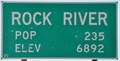 view gallery view gallerySW50.4 km | Rock River, Wyoming ~ Elevation 6892 in Elevation Signs This combination Elevation/Population sign is at the northern city limits of Rock River, Wyoming on US Highway 30/287 (4th Street). posted by: brwhiz location: Wyoming date approved: 09/24/2012 last visited: never |
 view gallery view gallerySW50.4 km |  Rock River, Wyoming ~ Population 235 Rock River, Wyoming ~ Population 235
in Population Signs This combination Elevation/Population sign is at the northern city limits of Rock River, Wyoming on US Highway 30/287 (4th Street). posted by: brwhiz location: Wyoming date approved: 09/25/2012 last visited: never |
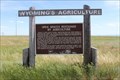 view gallery view galleryE50.4 km | Open Spaces Sustained by Agriculture - Dwyer Junction, WY in Wyoming Historical Markers A Wyoming's Agriculture marker stands along the sidewalk leading to the scenic overlook at the Dwyer Junction Rest Area, well north of Wheatland, providing some background about the agriculture that sustains this area. posted by: QuarrellaDeVil location: Wyoming date approved: 06/19/2020 last visited: 09/29/2021 |
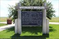 view gallery view galleryE50.4 km | Wildland Diversity - Dwyer Junction, WY in Wyoming Historical Markers A Wyoming's Wildlife marker stands along the sidewalk at the edge of the Dwyer Junction Rest Area, well north of Wheatland, noting that, yes, believe it or not, there is a diversity of wildlife to be found in the mountains in the area. posted by: QuarrellaDeVil location: Wyoming date approved: 06/05/2020 last visited: 09/29/2021 |
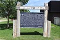 view gallery view galleryE50.5 km | Wildland Diversity - Dwyer Junction, WY in Wyoming Historical Markers A Wyoming's Wildlife marker stands along the sidewalk in front of the Dwyer Junction Rest Area, well north of Wheatland, noting that, yes, believe it or not, there is a diversity of wildlife to be found in the mountains in the area. posted by: QuarrellaDeVil location: Wyoming date approved: 06/05/2020 last visited: never |
 view gallery view galleryE50.5 km |  Patrolman Chris Logsdon - Dwyer Junction, WY Patrolman Chris Logsdon - Dwyer Junction, WY
in Police Memorials A memorial placed by the Wyoming Highway Patrol stands along the sidewalk at the Dwyer Junction Rest Area, well north of Wheatland, honoring Wyoming Highway Patrolman Chris Logsdon, who was killed in a tragic accident southwest of here in 1998. posted by: QuarrellaDeVil location: Wyoming date approved: 06/05/2020 last visited: 09/29/2021 |
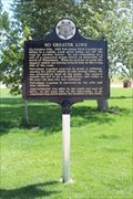
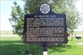 view gallery view galleryE50.5 km | No Greater Love - Dwyer Junction, WY in Wyoming Historical Markers A marker placed by the Wyoming Highway Patrol stands along the sidewalk at the Dwyer Junction Rest Area, well north of Wheatland, honoring Wyoming Highway Patrolman Chris Logsdon, who was killed in a tragic accident southwest of here in 1998. posted by: QuarrellaDeVil location: Wyoming date approved: 05/25/2020 last visited: 09/29/2021 |
|