 view gallery view gallery NW4.3 km NW4.3 km
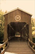
|   McKee Bridge McKee Bridge
in Covered Bridges McKee Bridge is Oregon’s southernmost span resting only eight miles from the California border. posted by:  Capt73 Capt73 location: Oregon date approved: 08/29/2008 last visited: 11/30/2014 |
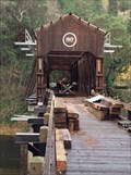 view gallery view galleryNW4.3 km |  McKee Bridge - Jackson County, Oregon McKee Bridge - Jackson County, Oregon
in U.S. National Register of Historic Places Historic Covered Bridge built in 1917 posted by: ddtfamily location: Oregon date approved: 12/26/2014 last visited: never |
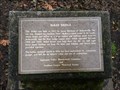 view gallery view galleryNW4.3 km |  McKee Bridge - Jackson County, Oregon McKee Bridge - Jackson County, Oregon
in Oregon Historical Markers Marker providing historic information about the McKee Covered Bridge posted by: ddtfamily location: Oregon date approved: 12/26/2014 last visited: never |
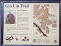 view gallery view galleryNW4.5 km | Gin Lin Trail - Jackson County, Oregon in Oregon Historical Markers Marker describing the historic mining operation in this area posted by: ddtfamily location: Oregon date approved: 12/26/2014 last visited: never |
 view gallery view gallery N6.3 km N6.3 km
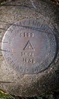
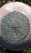
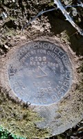
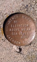
|  US Army Engineers 'S 199' BM - Jackson County, OR US Army Engineers 'S 199' BM - Jackson County, OR
in U.S. Benchmarks This USGS benchmark is located along Upper Applegate Rd and just south of the Star Ranger Station in Jackson County, OR. posted by:  NW_history_buff NW_history_buff location: Oregon date approved: 03/15/2013 last visited: never |
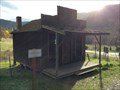
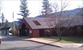 view gallery view galleryN6.4 km |  Star Ranger Station - Jackson County, OR Star Ranger Station - Jackson County, OR
in Ranger Stations This historic ranger station is located along Upper Applegate Rd in Jackson County, OR. posted by: NW_history_buff location: Oregon date approved: 04/12/2013 last visited: 11/30/2014 |
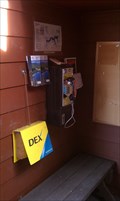 view gallery view galleryN6.4 km |  Star Ranger Station Payphone - Jackson County, OR Star Ranger Station Payphone - Jackson County, OR
in Payphones This payphone is located near the front entrance to the Star Ranger Station along Upper Applegate Rd in Jackson County, OR. posted by: NW_history_buff location: Oregon date approved: 04/13/2013 last visited: never |
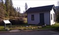
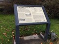 view gallery view galleryN6.4 km | The Old "Tack Room" - Jackson County, Oregon in Oregon Historical Markers Marker providing information about this historic federal building posted by: ddtfamily location: Oregon date approved: 12/02/2014 last visited: 04/06/2013 |
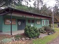
 view gallery view galleryN6.4 km | Star Ranger Station Building, Old - Jackson County, OR in U.S. National Register of Historic Places This historic 100+ yr-old structure was the first ranger station built in the area and is located just east of Upper Applegate Rd and north of the current ranger station in Jackson County, OR. posted by: NW_history_buff location: Oregon date approved: 04/12/2013 last visited: 11/30/2014 |
 view gallery view galleryN6.4 km |  FIRST - Administrative Headquarters for the New Applegate Ranger District FIRST - Administrative Headquarters for the New Applegate Ranger District
in First of its Kind This historic 100+ yr-old structure was the first ranger station built in the area and is located just east of Upper Applegate Rd and north of the current ranger station in Jackson County, OR. posted by: NW_history_buff location: Oregon date approved: 04/12/2013 last visited: 11/30/2014 |
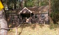
 view gallery view galleryN6.4 km |  Star Ranger Station Building ('Tack Room') - Jackson County, OR Star Ranger Station Building ('Tack Room') - Jackson County, OR
in Relocated Structures This historic 100+ yr-old structure was the first ranger station built in the area and is located just east of Upper Applegate Rd and north of the current ranger station in Jackson County, OR. posted by: NW_history_buff location: Oregon date approved: 04/12/2013 last visited: 11/30/2014 |
 view gallery view galleryN6.4 km |  OLDEST -- Forest Service Building Extant in Southwestern Oregon OLDEST -- Forest Service Building Extant in Southwestern Oregon
in Superlatives This historic 100+ yr-old structure was the first ranger station built in the area and is located just east of Upper Applegate Rd and north of the current ranger station in Jackson County, OR. posted by: NW_history_buff location: Oregon date approved: 04/12/2013 last visited: 11/30/2014 |
 view gallery view galleryN6.4 km | Star Ranger Station - Jackson County, OR in U.S. National Register of Historic Places This historic NRHP structure is located just west and on a hillside off of Upper Applegate Rd in Jackson County, OR. posted by: NW_history_buff location: Oregon date approved: 04/12/2013 last visited: 11/30/2014 |
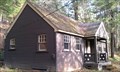 view gallery view galleryN6.4 km |  Star Ranger Station - Jackson County, OR Star Ranger Station - Jackson County, OR
in Civilian Conservation Corps This historic CCC structure is located just west of Upper Applegate Rd and on a hillside, across the road from the current ranger station in Jackson County, OR. posted by: NW_history_buff location: Oregon date approved: 04/16/2013 last visited: 11/30/2014 |
 view gallery view galleryN6.9 km | USGS 'X 199' BM - Jackson County, OR in U.S. Benchmarks This USGS benchmark is located along Eastside Rd in Jackson County, OR posted by: NW_history_buff location: Oregon date approved: 03/15/2013 last visited: never |
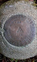
 view gallery view galleryN7.4 km | US Army Engineers 'R 199 RESET' BM - Jackson County, OR in U.S. Benchmarks This USGS benchmark is located along Upper Applegate Rd in Jackson County, OR. posted by: NW_history_buff location: Oregon date approved: 03/15/2013 last visited: never |
 view gallery view gallery NE9.7 km NE9.7 km
|  Buncom, Oregon Buncom, Oregon
in Ghost Towns The last remaining ghost town in Southern Oregon posted by: ddtfamily location: Oregon date approved: 02/15/2013 last visited: never |
 view gallery view galleryN10.3 km |  Applegate Valley Community Grange No. 839 - Jackson County, Oregon Applegate Valley Community Grange No. 839 - Jackson County, Oregon
in Grange Halls Grange building serving the Applegate Valley posted by: ddtfamily location: Oregon date approved: 12/10/2014 last visited: never |
 view gallery view galleryN14 km | US Army Engineers 'N 199' BM - Jackson County, OR in U.S. Benchmarks This USGS benchmark is located along Upper Applegate Rd in Jackson County, OR. posted by: NW_history_buff location: Oregon date approved: 03/15/2013 last visited: never |
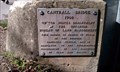 view gallery view galleryN14.3 km |  Cantrall Bridge - 1960 - Jackson County, OR Cantrall Bridge - 1960 - Jackson County, OR
in Bridge Date Stones and Plaques This bridge spans Upper Applegate River in Jackson County, OR. posted by: NW_history_buff location: Oregon date approved: 04/25/2013 last visited: 12/06/2014 |
 view gallery view galleryN14.3 km | Jackson County BM - Cantrall Bridge - Jackson County, OR in U.S. Benchmarks This benchmark is located on the Cantrall Bridge in Jackson County, OR. posted by: NW_history_buff location: Oregon date approved: 03/20/2013 last visited: never |
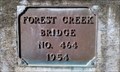 view gallery view galleryN15.3 km | Forest Creek Bridge No. 464 - 1954 - Jackson County, OR in Bridge Date Stones and Plaques This bridge is located along Hamilton Rd spanning Forest Creek in Jackson County, OR. posted by: NW_history_buff location: Oregon date approved: 04/07/2013 last visited: never |
 view gallery view galleryN15.9 km |  Ruch Bicentennial Marker - Ruch, OR Ruch Bicentennial Marker - Ruch, OR
in Spirit of '76 This historical marker is located in the community of Ruch, Oregon, just off Hwy 238. posted by: NW_history_buff location: Oregon date approved: 04/29/2013 last visited: 12/06/2014 |
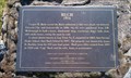 view gallery view galleryN15.9 km | Ruch Historical Marker - Ruch, Oregon in Oregon Historical Markers This historical marker is located in the community of Ruch, Oregon, just off Hwy 238. posted by: NW_history_buff location: Oregon date approved: 04/07/2013 last visited: 12/06/2014 |
 view gallery view galleryN15.9 km |  Ruch, Oregon ~ U.S.A. Ruch, Oregon ~ U.S.A.
in People-Named Places The community of Ruch (pronounced like 'swoosh') is named after Casper Ruch, an early settler who established the township's first post office and general store. posted by: NW_history_buff location: Oregon date approved: 04/13/2013 last visited: 12/06/2014 |
|