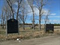
 view gallery view gallery E2.9 km E2.9 km
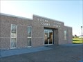
|   Hooker County Courthouse - Mullen, NE Hooker County Courthouse - Mullen, NE
in U.S. National Register of Historic Places This 1912 brick courthouse serves one of Nebraska's smaller counties. posted by:  NevaP NevaP location: Nebraska date approved: 09/03/2008 last visited: never |
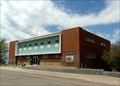
 view gallery view galleryE2.9 km |  Hooker County Courthouse, Mullen, Nebraska Hooker County Courthouse, Mullen, Nebraska
in Courthouses This nicely preserved 1912 Courthouse serves one of the Nebraska Sandhills counties. posted by: NevaP location: Nebraska date approved: 09/05/2008 last visited: never |
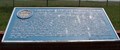
 view gallery view galleryE23 km |  Hardy Ranch - Thompson Pasture Hardy Ranch - Thompson Pasture
in U.S. Benchmarks Benchmark is located on a concrete post approximately one foot off the ground. Elevation of Benchmark is +/- 3100-feet above sea level. posted by:  R A A R A A location: Nebraska date approved: 12/09/2011 last visited: never |
 view gallery view galleryE42.5 km | Thomas County Courthouse, Thedford, NE in Courthouses Built in 2006, this is one of the newest courthouses in Nebraska. posted by: NevaP location: Nebraska date approved: 09/08/2008 last visited: never |
 view gallery view galleryE45.4 km |  Sandhills Sandhills
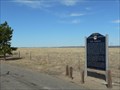
in Nebraska Historical Markers Sand dunes covering neary 25% of Nebraska are scenic and topographically unique. Cattlemen began commercial grazing operations in the 1870s. posted by: plainsdrifter358 location: Nebraska date approved: 05/11/2008 last visited: 04/11/2023 |
 view gallery view gallery S55.4 km S55.4 km
| McPherson County Courthouse, Tryon, Nebraska in Courthouses McPherson County's courthouse is one of the newest in the state. posted by: NevaP location: Nebraska date approved: 06/12/2008 last visited: never |
 view gallery view gallery W56.3 km W56.3 km
| Grant County Courthouse, Hyannis, Nebraska in Courthouses This modern brick courthouse is decorated with a portrait of a Hereford cow. posted by: NevaP location: Nebraska date approved: 08/29/2008 last visited: never |
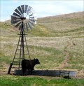 view gallery view galleryW59.7 km |  Nebraska Sandhills Windmill Nebraska Sandhills Windmill
in Windmills This windmill is typical of many currently used to water cattle in the Sandhills region of Nebraska. posted by: NevaP location: Nebraska date approved: 05/23/2008 last visited: never |
 view gallery view galleryE66.6 km |  Nebraska National Forest (Bessey Ranger District) Nebraska National Forest (Bessey Ranger District)
in Public Access Lands A national forest in the center of Nebraska, featuring one of the largest hand-planted forests in the world. posted by:  Zaphody3k Zaphody3k location: Nebraska date approved: 10/14/2014 last visited: 06/27/2014 |
 view gallery view gallery SW72.6 km SW72.6 km
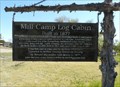
| Mill Camp Cabin in Nebraska Historical Markers This signboard is by a pioneer log cabin now located on the north edge of Arthur, NE. posted by: NevaP location: Nebraska date approved: 06/11/2008 last visited: never |
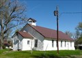 view gallery view gallerySW72.7 km | Pilgrim Holiness Church, Arthur, NE in U.S. National Register of Historic Places This Church, also known as the Baled Hay church, has a unique construction. posted by: NevaP location: Nebraska date approved: 06/13/2008 last visited: never |
 view gallery view gallerySW72.9 km | Arthur County First Courthouse, Arthur County NE in Courthouses At the time it was in use, this frame courthouse was believed to be the smallest courthouse in the United States posted by: NevaP location: Nebraska date approved: 06/12/2008 last visited: never |
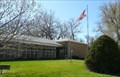 view gallery view gallerySW72.9 km | Arthur County Courthouse, Arthur, NE in Courthouses This courthouse serves the smallest Nebraska County. posted by: NevaP location: Nebraska date approved: 06/12/2008 last visited: never |
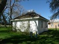 view gallery view gallerySW72.9 km | First Arthur County Courthouse and Jail, Arthur Nebraska in U.S. National Register of Historic Places This white frame courthouse and its associated white frame jail are preserved in a park behind the present Arthur County Courthouse. posted by: NevaP location: Nebraska date approved: 06/13/2008 last visited: never |
 view gallery view gallery SE78.4 km SE78.4 km
| Logan County Courthouse, Stapleton, NE in Courthouses This Courthouse serves a county with a population of 774. posted by: NevaP location: Nebraska date approved: 06/02/2008 last visited: never |
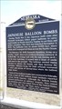 view gallery view galleryW97.5 km | Japanese Balloon Bombs - between Ellsworth and Gordon, NE in Nebraska Historical Markers Historical Marker on State Highway 27 between Ellsworth and Gordon posted by: Jynjur location: Nebraska date approved: 06/20/2016 last visited: 06/24/2021 |
 view gallery view gallery NE99 km NE99 km
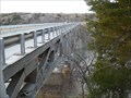
| Bryan Bridge - Valentine, NE in U.S. National Register of Historic Places Award winning 1932 Bridge along old US 20 near Valentine crossing the Niobrara River. posted by: plainsdrifter358 location: Nebraska date approved: 11/14/2007 last visited: 06/27/2014 |
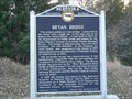 view gallery view galleryNE99 km | Bryan Bridge in Nebraska Historical Markers 1932 Bridge along old US 20 near Valentine crossing the Niobrara River. posted by: plainsdrifter358 location: Nebraska date approved: 11/13/2007 last visited: 10/21/2019 |
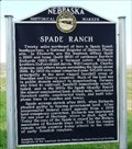 view gallery view galleryW99.1 km | Spade Ranch in Nebraska Historical Markers The marker tells of ranching activity in the area and the ranchers conflicts with homestead law. posted by: NevaP location: Nebraska date approved: 08/31/2008 last visited: 01/31/2009 |
 view gallery view galleryS100.1 km | The Great Platte River Road # 111 in Nebraska Historical Markers The trek west. posted by: Biker Ozzy location: Nebraska date approved: 03/23/2010 last visited: 09/23/2015 |
 view gallery view galleryNE100.4 km | Fort Niobrara in Nebraska Historical Markers Fort Niobrara, built in 1880 near Valentine, NE, was established to provide military protection of settlers in the region. posted by: plainsdrifter358 location: Nebraska date approved: 05/11/2008 last visited: 06/24/2009 |
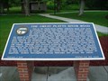
 view gallery view galleryS100.4 km | The Great Platte River Road in Nebraska Historical Markers This marker, describing emigrant travel along the Platte river, stands close to still visible wagon wheel ruts. posted by: NevaP location: Nebraska date approved: 06/07/2007 last visited: 07/08/2012 |
 view gallery view galleryS100.6 km | Crossing the Overland Trail in Nebraska Historical Markers This marker stands by the still remaining traces of the great Overland Trail. posted by: NevaP location: Nebraska date approved: 06/04/2007 last visited: 01/22/2014 |
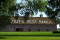 view gallery view galleryS100.6 km | Scout's Rest Ranch - North Platte, Nebraska in U.S. National Register of Historic Places Scouts' Rest Ranch was owned by Buffalo Bill Cody. It is now a State Historic Site and both Cody's home and the coral can be visited.
posted by: Hikenutty location: Nebraska date approved: 08/09/2007 last visited: 02/23/2022 |
 view gallery view galleryS100.6 km |  Buffalo Bill Cody's Ranch - North Platte, Nebraska Buffalo Bill Cody's Ranch - North Platte, Nebraska
in Photos Then and Now This is a photo of the inside of Buffalo Bill Cody's barn, showing the horse stalls. Scouts' Rest Ranch is now a State Historic Site and both Cody's home and the barn can be visited.
posted by: Hikenutty location: Nebraska date approved: 08/09/2007 last visited: 02/23/2022 |
|