 view gallery view gallery SW1.9 km SW1.9 km
|   Burro Crossing Burro Crossing
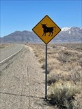
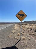
in Uncommon Crossing Signs Not much else around but a few burro crossing signs, a horse crossing, and bull crossing. posted by:  funsigns funsigns location: Nevada date approved: 04/19/2021 last visited: never |
 view gallery view gallery SE8.9 km SE8.9 km
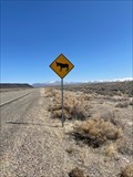
| Crazy Bulls in Uncommon Crossing Signs It is not just an ordinary lazy cow crossing sign. There may not be much else to look at in this part of the country but evidently you need to watch out for bulls. posted by: funsigns location: Nevada date approved: 04/19/2021 last visited: never |
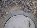
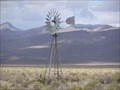 view gallery view gallerySE9.8 km |  Bog Hot Well Windmill, NV Bog Hot Well Windmill, NV
in Windmills Windmill at Bog Hot Well. posted by:  Volcanoguy Volcanoguy location: Nevada date approved: 10/18/2007 last visited: 10/19/2007 |
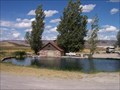 view gallery view gallerySW10.5 km |  Virgin Valley, Nevada Virgin Valley, Nevada
in Civilian Conservation Corps The warm spring and shower house built by the CCC at the Virgin Valley campground of the Sheldon NWR in northern Nevada. posted by: rvdriverbill location: Nevada date approved: 09/28/2005 last visited: 09/23/2007 |
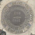
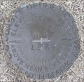 view gallery view gallery W21.6 km W21.6 km
|  MV0096 - USCGS B67, NV MV0096 - USCGS B67, NV
in U.S. Benchmarks USCGS Benchmark B67. posted by: Volcanoguy location: Nevada date approved: 10/20/2007 last visited: 10/20/2007 |
 view gallery view gallery E23.5 km E23.5 km
| MV0279 - NGS M431, NV in U.S. Benchmarks NGS Benchmark M431. posted by: Volcanoguy location: Nevada date approved: 10/20/2007 last visited: 10/20/2007 |
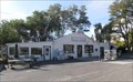
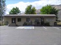 view gallery view galleryE23.8 km |  Denio, NV, 89404 Denio, NV, 89404
in U.S. Post Offices The Denio, NV Post Office. posted by: Volcanoguy location: Nevada date approved: 09/29/2007 last visited: 04/28/2008 |
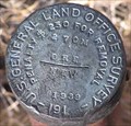
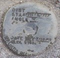 view gallery view galleryW31.4 km | NHD A271+51.87, NV in U.S. Benchmarks Nevada Highway Department Right of Way Marker posted by: Volcanoguy location: Nevada date approved: 10/19/2007 last visited: 10/19/2007 |
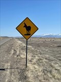
 view gallery view galleryW32.3 km | Wild Horses in Uncommon Crossing Signs Watch for wild horses! posted by: funsigns location: Nevada date approved: 04/19/2021 last visited: never |
 view gallery view galleryW35.2 km | GLO NEV/ORE 270M, NV/OR in U.S. Benchmarks Boundary Marker 270M between Nevada and Oregon posted by: Volcanoguy location: Nevada date approved: 10/19/2007 last visited: 10/19/2007 |
 view gallery view galleryW35.6 km |  Nevada / Oregon at NV-140 / OR-291 Nevada / Oregon at NV-140 / OR-291
in Border Crossings Nevada/Oregon crossing when traveling on NV-140/OR-291 between Denio Jct, NV and Adel, OR. posted by: Left Coast Labs location: Nevada date approved: 08/17/2009 last visited: 09/02/2010 |
 view gallery view gallerySE38.6 km | Pronghorn Antelope in Uncommon Crossing Signs Not much to see out here, but we in fact did see some real pronghorn in this vicinity. posted by: funsigns location: Nevada date approved: 04/19/2021 last visited: never |
 view gallery view gallery NE43.5 km NE43.5 km
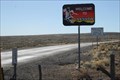
| Fields, OR. 97710 in U.S. Post Offices The post office is in the general store in Fields, OR posted by: Volcanoguy location: Oregon date approved: 10/25/2009 last visited: 09/16/2015 |
 view gallery view galleryW66.1 km |  Blizzard Gap, OR Blizzard Gap, OR
in Named Mountain Gaps Ore. Hwy. 140 passes through Blizard Gap. posted by: Volcanoguy location: Oregon date approved: 10/18/2007 last visited: 07/03/2007 |
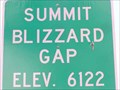 view gallery view galleryW66.1 km |  6122 Feet, Blizzard Gap, OR 6122 Feet, Blizzard Gap, OR
in Elevation Signs Elevation sign at the summit of Blizzard Gap. posted by: Volcanoguy location: Oregon date approved: 10/27/2007 last visited: 07/03/2007 |
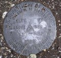 view gallery view galleryW66.1 km | USGS 117-HRP, OR in U.S. Benchmarks USGS Benchmark 117-HRP posted by: Volcanoguy location: Oregon date approved: 10/20/2007 last visited: 10/20/2007 |
 view gallery view galleryNE71.3 km | NX0078 - USCGS Y65, Oregon in U.S. Benchmarks U.S. Coast & Geodetic Survey benchmark Y65 posted by: Volcanoguy location: Oregon date approved: 02/27/2011 last visited: 10/01/2009 |
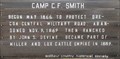 view gallery view galleryNE73.2 km |  Camp C.F. Smith Camp C.F. Smith
in Oregon Historical Markers This history sign is located along Whitehorse Road at the junction to the Whitehorse Ranch. posted by: Volcanoguy location: Oregon date approved: 02/28/2011 last visited: 10/01/2009 |
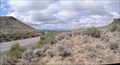
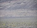 view gallery view galleryW77.4 km |  Lake Warner Shorelines, OR Lake Warner Shorelines, OR
in Places of Geologic Significance Pluvial lake shorelines along Ore. Hwy. 140 east of Adel, Oregon. posted by: Volcanoguy location: Oregon date approved: 03/19/2008 last visited: 07/03/2007 |
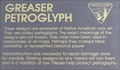 view gallery view galleryW80.3 km | Greaser Petroglyph, OR in Oregon Historical Markers Sign at the Greaser Petroglyph off Ore Hwy 140 near Greaser Canyon. posted by: Volcanoguy location: Oregon date approved: 10/29/2007 last visited: 10/29/2007 |
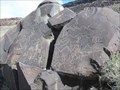 view gallery view galleryW80.3 km |  Greaser Petroglyph Site Greaser Petroglyph Site
in U.S. National Register of Historic Places Petroglyphs north of Ore. Hwy. 140 near Greaser Canyon. posted by: Volcanoguy location: Oregon date approved: 11/13/2007 last visited: 11/13/2007 |
 view gallery view galleryW80.3 km |  Greaser Petroglyph, OR Greaser Petroglyph, OR
in Pictographs Petroglyphs north of Ore. Hwy. 140 near Greaser Canyon. posted by: Volcanoguy location: Oregon date approved: 10/16/2007 last visited: 10/16/2007 |
 view gallery view gallery N85.3 km N85.3 km
|  Steen’s Summit Steen’s Summit
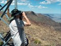
in Mountain Summits This entire area has wonderful views in all directions. We love landscapes, especially with long views. This one fits the bill nicely. My wife was very disappointed when she tried to hike to a mountain view point in the Cascades. Too tired from years of cancer treatments she could not make the climb. So, we went for this easy one. posted by: JLJL location: Oregon date approved: 09/07/2005 last visited: 09/03/2012 |
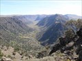 view gallery view galleryN86.3 km |  Big Indian Gorge Viewpoint Big Indian Gorge Viewpoint
in Scenic Roadside Look-Outs The Big Indian Gorge VP along the Steens Mountain Loop Road. posted by: Volcanoguy location: Oregon date approved: 03/05/2011 last visited: 10/12/2010 |
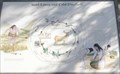 view gallery view galleryN86.3 km | Seed Eaters and Cold Dwellers in Oregon Historical Markers History sign about the Northern Paiutes on Steens Mountain. The sign located off the Steens Mountain Loop Road at the Big Indian Grorge VP. posted by: Volcanoguy location: Oregon date approved: 03/07/2011 last visited: 10/12/2010 |
|