 view gallery view gallery E2.6 km E2.6 km
|   Zip's Diner - "Connecticut Conundrum" - Dayville, CT Zip's Diner - "Connecticut Conundrum" - Dayville, CT
in Zippy the Pinhead Locations "Connecticut Conundrum" features Zip's Diner at 725 Hartford Pike in Dayville, CT. posted by:  neoc1 neoc1 location: Connecticut date approved: 07/04/2022 last visited: never |
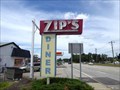 view gallery view galleryE2.6 km | Zip's Diner - "Measure of a Man" - Dayville, CT in Zippy the Pinhead Locations "Measure of a Man" features Bert and Bob having a conversation in Zip's Diner at 725 Hartford Pike in Dayville, CT. posted by: neoc1 location: Connecticut date approved: 07/22/2022 last visited: never |
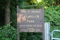 view gallery view galleryE2.7 km |  Cat Hollow Town Park - Killingly, CT Cat Hollow Town Park - Killingly, CT
in Municipal Parks and Plazas The Cat Hollow Town Park was opened in 2003. The park contains a 0.5-mile trail along Cat Hollow Road that is suitable for bicycles and strollers. The road is closed off to traffic. The trail parallels the Whetstone Brook and a beautiful mill pond and waterfalls. The site of the original mill is about halfway down the trail. posted by:  dremoto dremoto location: Connecticut date approved: 09/12/2008 last visited: 04/18/2009 |
 view gallery view gallery SW4.2 km SW4.2 km
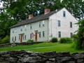
|  Putnam Farm - Brooklyn CT Putnam Farm - Brooklyn CT
in U.S. National Register of Historic Places This property is significant because of its connection with the life of General Israel Putnam, Connecticut's foremost hero of the Revolutionary War. posted by:  nomadwillie nomadwillie location: Connecticut date approved: 03/17/2012 last visited: never |
 view gallery view gallery S4.5 km S4.5 km
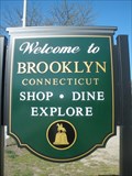
|  Brooklyn, CT Brooklyn, CT
in Small Town, Big Name With a little over 7,000 residents, Brooklyn, Connecticut is much smaller than the better known Brooklyn, New York, which has about 2.5 million residents. posted by: Chasing Blue Sky location: Connecticut date approved: 10/16/2013 last visited: 05/06/2013 |
 view gallery view galleryS4.5 km |  Brooklyn, Connecticut Brooklyn, Connecticut
in Wikipedia Entries With a little over 7,000 residents, the town of Brooklyn, Connecticut is located in Windham County, in the northeast area of the state. posted by: Chasing Blue Sky location: Connecticut date approved: 10/22/2013 last visited: 05/06/2013 |
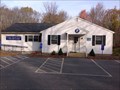
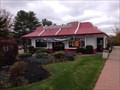 view gallery view galleryS4.5 km |  McDonald's Route 6 - Brooklyn, CT McDonald's Route 6 - Brooklyn, CT
in McDonald's Restaurants Located on route 6 next door to the bowling alley posted by: CTBruce location: Connecticut date approved: 11/08/2014 last visited: never |
 view gallery view gallery SE4.5 km SE4.5 km
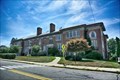
|  Old Killingly High School - Killingly CT Old Killingly High School - Killingly CT
in Former Schools The Old Killingly High School is a historic school was built in 1908 and enlarged in 1927, it served as the town's high school until 1965, and then its junior high school until 1990. Today it is town's police headquarters and community center. posted by: nomadwillie location: Connecticut date approved: 03/22/2023 last visited: never |
 view gallery view gallerySE4.5 km | Old Killingly High School - Killingly CT in Wikipedia Entries The Old Killingly High School is a historic school was built in 1908 and enlarged in 1927, it served as the town's high school until 1965, and then its junior high school until 1990. Today it is town's police headquarters and community center. posted by: nomadwillie location: Connecticut date approved: 03/22/2023 last visited: never |
 view gallery view gallerySE4.5 km | Killingly High School, Old - Killingly CT in U.S. National Register of Historic Places The Old Killingly High School is a historic school was built in 1908 and enlarged in 1927, it served as the town's high school until 1965, and then its junior high school until 1990. Today it is town's police headquarters and community center. posted by: nomadwillie location: Connecticut date approved: 03/24/2023 last visited: never |
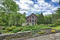 view gallery view galleryE5.3 km |  Elliottville Lower Mill - East Killingly CT Elliottville Lower Mill - East Killingly CT
in Converted Factories Very scenic mill that has been repurposed into a studio and residence. posted by: nomadwillie location: Connecticut date approved: 06/11/2017 last visited: never |
 view gallery view galleryE5.3 km | Elliottville Lower Mill - East Killingly CT in Wikipedia Entries Very scenic mill that has been repurposed into a studio and residence. posted by: nomadwillie location: Connecticut date approved: 05/31/2017 last visited: never |
 view gallery view galleryE5.3 km | Elliottville Lower Mill - East Killingly CT in U.S. National Register of Historic Places Very scenic mill that has been repurposed into a studio and residence. posted by: nomadwillie location: Connecticut date approved: 05/30/2017 last visited: never |
 view gallery view galleryE5.3 km |  Elliottville Lower Mill - East Killingly CT Elliottville Lower Mill - East Killingly CT
in Water Mills Very scenic mill that has been repurposed into a studio and residence, powered by the Whetstone Brook. posted by: nomadwillie location: Connecticut date approved: 05/30/2017 last visited: never |
 view gallery view galleryE5.3 km |  Whetstone Brook Dam - Danielson, CT Whetstone Brook Dam - Danielson, CT
in Water Dams Best seen from Peep Toad Road posted by: nomadwillie location: Connecticut date approved: 05/30/2017 last visited: never |
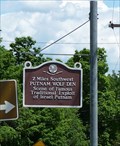 view gallery view gallery NW5.3 km NW5.3 km
|  Putnam Wolf Den - Pomfret CT Putnam Wolf Den - Pomfret CT
in Connecticut Historical Markers Located at the intersection of RT 44 and CT 101 in Pomfret posted by: nomadwillie location: Connecticut date approved: 03/27/2012 last visited: 09/26/2012 |
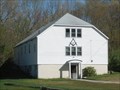 view gallery view gallerySW5.5 km |  Moriah Lodge No. 15 A.F. & A.M. - Brooklyn, CT Moriah Lodge No. 15 A.F. & A.M. - Brooklyn, CT
in Masonic Temples The Moriah Lodge No. 15 is situated east of the center of Brooklyn, Connecticut along Highway 6, also known as Providence Road. posted by: Chasing Blue Sky location: Connecticut date approved: 10/14/2013 last visited: 05/06/2013 |
 view gallery view gallery W5.5 km W5.5 km
|  Mashamoquet Brook State Park - Pomfret, CT Mashamoquet Brook State Park - Pomfret, CT
in State/Provincial Parks Entrance is located on Wolf Den Rd which is about .8 miles from RT 44 posted by: nomadwillie location: Connecticut date approved: 03/25/2012 last visited: never |
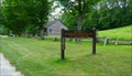
 view gallery view galleryNW5.5 km |  Pomfret Historical Society - Pomfret CT Pomfret Historical Society - Pomfret CT
in Historical Society Headquarters Built in 1841 serving as the original town hall, it is now the Pomfret Historical Society's headquarters posted by: nomadwillie location: Connecticut date approved: 03/24/2012 last visited: never |
 view gallery view galleryNW5.5 km | Pomfret Town House - Pomfret CT in U.S. National Register of Historic Places Pomfret Town House is a one-story gable-roofed building erected in 1841 to accomodates Pomfret's town meetings. posted by: nomadwillie location: Connecticut date approved: 03/16/2012 last visited: never |
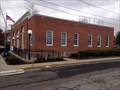 view gallery view gallerySE6 km |  Danielson, CT - 06239 Danielson, CT - 06239
in U.S. Post Offices Located in downtown Danielson at the corner of Main Street and Water street. posted by: CTBruce location: Connecticut date approved: 11/08/2014 last visited: never |
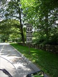 view gallery view galleryNW6.3 km |  Connecticut State Route 169 - Pomfret CT Connecticut State Route 169 - Pomfret CT
in National Scenic Byways This is a great ride thru eastern Connecticut on a lazy summer day. posted by: nomadwillie location: Connecticut date approved: 03/16/2012 last visited: never |
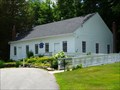
 view gallery view galleryW6.3 km |  Wolf Den Grange - Pomfret, CT Wolf Den Grange - Pomfret, CT
in Grange Halls Located beside route 44 in Pomfret, CT posted by: CTBruce location: Connecticut date approved: 11/20/2014 last visited: never |
 view gallery view gallerySE6.6 km | Old Furnace State Park - Killingly, CT in State/Provincial Parks The site of a former iron furnace, Old Furnace State Park is a 367 acre park, created as a town park in 1909, then transferred to the state in 1918. It is situated near Killingly in Windham County, in the northeast area of Connecticut. posted by: Chasing Blue Sky location: Connecticut date approved: 10/25/2013 last visited: 05/06/2013 |
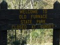 view gallery view gallerySE6.6 km | Old Furnace State Park - Killingly, CT in Wikipedia Entries The site of a former iron furnace, Old Furnace State Park is a 367 acre park, created as a town park in 1909, then transferred to the state in 1918. It is situated near Killingly in Windham County, in the northeast area of Connecticut. posted by: Chasing Blue Sky location: Connecticut date approved: 10/25/2013 last visited: 05/06/2013 |
|