 view gallery view gallery S1.3 km S1.3 km
|   K'Burgh Cemetery - Catawba Island, Ohio K'Burgh Cemetery - Catawba Island, Ohio
in Worldwide Cemeteries This is a very small family cemetery on Catawba Island posted by:  GT.US GT.US location: Ohio date approved: 09/29/2009 last visited: 09/20/2011 |
 view gallery view galleryS1.6 km |  Catawba Township Fire Station Helipad - Ohio Catawba Township Fire Station Helipad - Ohio
in Helicopter Landing Pads This Helipad is located behind the Catawba Towship Fire Deptartment. posted by: GT.US location: Ohio date approved: 09/29/2009 last visited: never |
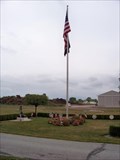 view gallery view gallery SE1.6 km SE1.6 km
|  Catawba Township Cemetery - Catawba Island, Ohio Catawba Township Cemetery - Catawba Island, Ohio
in Non-Specific Veteran Memorials This memorial is located in the Catawba Township Cemetery. posted by: GT.US location: Ohio date approved: 09/29/2009 last visited: 05/25/2013 |
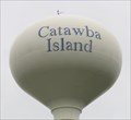 view gallery view galleryS1.6 km |  Catawba Island Water Tower - Port Clinton, Ohio Catawba Island Water Tower - Port Clinton, Ohio
in Water Towers The Catawba Island Water Tower is located next to Cedar Meadow Nature Preserve behind the Catawba Island Township Fire Department on E Cemetery Rd, Port Clinton, OH. posted by: denben location: Ohio date approved: 09/25/2014 last visited: never |
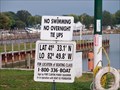 view gallery view gallerySE2.4 km |  Lat 41 33.1 N - LO 82 49.8 - Catawba Island, Ohio Lat 41 33.1 N - LO 82 49.8 - Catawba Island, Ohio
in Permanent Geographic Coordinates These coordinates are found at the West Harbor Boat Launch. posted by: GT.US location: Ohio date approved: 09/27/2009 last visited: never |
 view gallery view gallerySE4.7 km |  East Harbor State Park - Lakeside-Marblehead Ohio East Harbor State Park - Lakeside-Marblehead Ohio
in Coin-Op Binoculars Along the shore of Lake Erie at East Harbor State Park just behind a shelter house. posted by:  Mr. 0 Mr. 0 location: Ohio date approved: 08/07/2011 last visited: never |
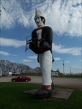 view gallery view gallerySE5 km |  Handless Jacques - Marblehead, Ohio Handless Jacques - Marblehead, Ohio
in Highway Giants - Muffler Men Jacques, the handless, traveling muffler man. posted by: Mr. 0 location: Ohio date approved: 04/29/2009 last visited: 05/14/2017 |
 view gallery view gallerySE5 km |  Jacques the Giant Sandwich Man Jacques the Giant Sandwich Man
in Giants of Commerce Giant 20-30 foot tall Jacques the Sandwich Man in Marblehead, Ohio near Lake Erie. Post an original picture, preferrably with you and your GPS. posted by: slammer47 location: Ohio date approved: 04/17/2009 last visited: 05/14/2017 |
 view gallery view galleryS6.3 km |  Erie–Ottawa International Airport - Port Clinton, OH Erie–Ottawa International Airport - Port Clinton, OH
in Airports Erie–Ottawa International Airport is three miles east of Port Clinton, in Ottawa County, Ohio. It operates two runways. posted by: bobfrapples8 location: Ohio date approved: 12/29/2021 last visited: never |
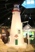 view gallery view galleryS6.6 km |  Marblehead Lighthouse - Port Clinton, OH Marblehead Lighthouse - Port Clinton, OH
in Exact Replicas The replica of the Marblehead Lighthouse is located inside the Lake Erie Shores & Islands Welcome Center West in Port Clinton, Ohio. posted by: denben location: Ohio date approved: 10/09/2014 last visited: never |
 view gallery view gallery N6.6 km N6.6 km
|  South Bass Island Lighthouse - Ohio South Bass Island Lighthouse - Ohio
in U.S. National Register of Historic Places This lighthouse is located at the southern tip of South Bass Island. posted by: GT.US location: Ohio date approved: 11/12/2010 last visited: 09/09/2017 |
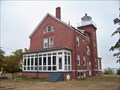 view gallery view galleryN6.6 km |  South Bass Island Lighthouse - Ohio South Bass Island Lighthouse - Ohio
in Coastal Lighthouses This lighthouse is located at the southern tip of South Bass Island. posted by: GT.US location: Ohio date approved: 09/29/2009 last visited: 09/08/2017 |
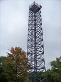 view gallery view galleryN6.6 km |  South Bass Island Weather Station - Ohio South Bass Island Weather Station - Ohio
in Weather Stations The South Bass Island Weather Station is located next to the lighthosue. posted by: GT.US location: Ohio date approved: 09/27/2009 last visited: 09/09/2017 |
 view gallery view galleryS6.6 km |  TIC - Lake Erie Shores & Islands Welcome Center - Port Clinton, OH TIC - Lake Erie Shores & Islands Welcome Center - Port Clinton, OH
in Tourist Information Centers - Visitor Centers Place to get information about the Lake Erie Islands in North Central Ohio posted by: uccacher location: Ohio date approved: 08/19/2011 last visited: 09/22/2014 |
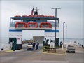 view gallery view galleryN6.6 km |  Millers Ferry - South Bass Island - Ohio Millers Ferry - South Bass Island - Ohio
in Ferries and Ferry Landings This is the stop for the ferry service between Catawba Island and Put-In-Bay, South Bass Island. posted by: GT.US location: Ohio date approved: 09/28/2009 last visited: 09/08/2017 |
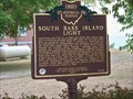 view gallery view galleryN6.6 km |  South Bass Island Light - 9-62 South Bass Island Light - 9-62
in Ohio Historical Markers This marker was placed at the end of Langram Road at the South end of the island. You can see the lighthouse from the sign. posted by: GT.US location: Ohio date approved: 09/27/2009 last visited: 09/17/2016 |
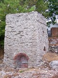 view gallery view galleryN6.6 km |  South Bass Island Lime Kiln - Ohio South Bass Island Lime Kiln - Ohio
in Ovens and Kilns This Lime Kiln is located at the Lime Kiln Dock on the south end of SOuth Bass Island. posted by: GT.US location: Ohio date approved: 09/28/2009 last visited: 09/08/2017 |
 view gallery view galleryN6.8 km |  Island Bike and Cart Rental - South Bass Island, Ohio Island Bike and Cart Rental - South Bass Island, Ohio
in Bicycle Rentals This bicycle rental is located near the Lime Kiln dock at SOuth Bass Island. posted by: GT.US location: Ohio date approved: 11/03/2010 last visited: 09/08/2017 |
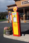 view gallery view galleryN6.8 km |  Island Bikes gas pumps - South Bass Island, Ohio Island Bikes gas pumps - South Bass Island, Ohio
in Vintage Gasoline Pumps This pair of Gas pumps are in front of the Island Bike Rental, Near the Lime Kiln boat ramp on South Bass Island. posted by: GT.US location: Ohio date approved: 11/03/2010 last visited: 09/08/2017 |
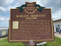 view gallery view galleryS6.9 km | World's Shortest Airline - Port Clinton, OH in Ohio Historical Markers World's Shortest Airline historical marker located behind the main terminal building of Erie-Ottawa International Airport. posted by: bobfrapples8 location: Ohio date approved: 07/07/2022 last visited: never |
 view gallery view galleryN7.1 km |  Atlas Statue - Put-in-Bay, Ohio Atlas Statue - Put-in-Bay, Ohio
in Atlas Statues This Atlas Statue was found on the side of the road. posted by: razalas location: Ohio date approved: 07/22/2014 last visited: 09/08/2017 |
 view gallery view gallerySE7.7 km | Danbury Water Tower - Danbury Township, OH in Water Towers This water tower is located at East Harbor Road in Danbury Township. posted by: monkeys4ever location: Ohio date approved: 09/06/2010 last visited: 08/27/2010 |
 view gallery view gallerySE7.9 km |  Kelly Cemetery Kelly Cemetery
in Abandoned Cemeteries Kelly Cemetery is located near Marblehead, Ohio in Ottawa County. posted by: OnD'Hunt location: Ohio date approved: 05/20/2010 last visited: 05/23/2013 |
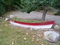 view gallery view galleryN8 km |  Flower pot Boat - South Bass Island, Ohio Flower pot Boat - South Bass Island, Ohio
in Landlocked Boats A rowboat call Paradise North is full of marigolds is in front of a family home on Meechan Street on South Bass Island. posted by: GT.US location: Ohio date approved: 09/29/2009 last visited: 09/08/2017 |
 view gallery view gallery SW8.2 km SW8.2 km
|  Jolly Roger - Port Clinton, Ohio Jolly Roger - Port Clinton, Ohio
in Fish and Chips Restaurants Well known for its fresh Lake Erie Perch. A small independent operation that is well known, and well liked. posted by: Mr. 0 location: Ohio date approved: 05/04/2009 last visited: 07/29/2011 |
|