 view gallery view gallery W0.2 km W0.2 km
|   Rose Marie Long Rose Marie Long
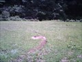
in Homemade Tombstones This homemade marker is made from a flat stone. posted by:  miatabug miatabug location: Pennsylvania date approved: 05/07/2008 last visited: 12/04/2011 |
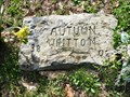 view gallery view galleryW0.2 km | Autumn Whitton in Homemade Tombstones This homemade marker is made from a flat stone. posted by: miatabug location: Pennsylvania date approved: 05/07/2008 last visited: 12/04/2011 |
 view gallery view gallery SW5.1 km SW5.1 km
|  Teddy Collins Apple orchard Teddy Collins Apple orchard
in Remains of Settlements Early 1900 apple orchard, Collin hay, apple, and cattle farm for the town of Nebraska Pa. posted by: nebraskapa location: Pennsylvania date approved: 02/27/2011 last visited: 06/07/2012 |
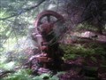 view gallery view galleryW6.1 km | Natural Gas Pumping Station - Nebraska, Pennsylvania in Remains of Settlements This is a vintage gas pump and well used for the supply of natural gas to the town of Nebraska PA. posted by: nebraskapa location: Pennsylvania date approved: 01/29/2011 last visited: 12/31/2011 |
 view gallery view gallery NW7.4 km NW7.4 km
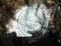
|  USGS EGB 1964 - Kingsley Twp Forest County PA USGS EGB 1964 - Kingsley Twp Forest County PA
in U.S. Benchmarks This is a Pennsylvania Department of Highways survey disk in Kingsley Township, Forest County. posted by:  shorbird shorbird location: Pennsylvania date approved: 05/30/2013 last visited: never |
 view gallery view gallery SE7.4 km SE7.4 km
|  NCT-Pennsylvania-Clarion-Route 66 Forest Clarion County Line NCT-Pennsylvania-Clarion-Route 66 Forest Clarion County Line
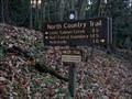
in North Country Trail North Country Trail Trailhead on the northern edge of Clarion County. This trailhead is located on Route 66, just before the Clarion and Forest County Line. posted by: DevinC location: Pennsylvania date approved: 02/22/2010 last visited: 08/26/2011 |
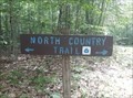
 view gallery view gallery N7.7 km N7.7 km
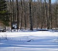
| NCT Pennsylvania - Kellettville Trailhead in North Country Trail This parking area is located in the Allegheny National Forest and offers 14.5 miles of northward hiking in the ANF. posted by: miatabug location: Pennsylvania date approved: 11/14/2009 last visited: never |
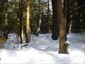
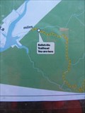 view gallery view galleryN7.7 km |  North Country Trail - Kellettville, Pennsylvania Trailhead North Country Trail - Kellettville, Pennsylvania Trailhead
in 'You Are Here' Maps This map is in a kiosk at a parking area for the North Country Trail. posted by: miatabug location: Pennsylvania date approved: 11/14/2009 last visited: never |
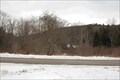
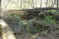
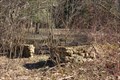 view gallery view galleryW9.7 km | Nebraska, Pennsylvania abandonated settlement in Remains of Settlements This is one of the few foundations left from the abandonated homes from the logging town of Nebraska Pennsylvania. posted by: nebraskapa location: Pennsylvania date approved: 05/17/2011 last visited: never |
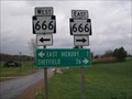 view gallery view galleryN9.8 km |  Double 666 - Whig Hill, Pennsylvania Double 666 - Whig Hill, Pennsylvania
in 666 Sightings UGH..........twice as powerful.......666 x 2! posted by: BarbershopDru location: Pennsylvania date approved: 05/31/2009 last visited: 12/04/2011 |
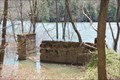 view gallery view galleryW10.1 km | Nebraska, Pennsylvania settlement in Remains of Settlements This is one of the few foundations left from the town of Nebraska, Pennsylvania before the building and flooding of the Tionesta lake Reservoir. posted by: nebraskapa location: Pennsylvania date approved: 05/17/2011 last visited: never |
 view gallery view galleryW10.3 km | Nebraska, Pennsylvania The Collin mansion in Remains of Settlements This is the remains of the Teddy Collin estate of Nebraska Pennsylvania. posted by: nebraskapa location: Pennsylvania date approved: 05/18/2011 last visited: 09/17/2011 |
 view gallery view gallery S10.3 km S10.3 km
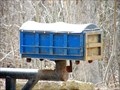
|  Trash Roll-off Mailbox Trash Roll-off Mailbox
in Themed Homemade Mailboxes At the end of the drive for Allied Waste Systems sits this custom mailbox made in the shape of one of the company's roll-off waste containers. posted by: miatabug location: Pennsylvania date approved: 03/15/2009 last visited: 12/04/2011 |
 view gallery view galleryW10.5 km |  Nebraska Pa School House Thinking Rock Nebraska Pa School House Thinking Rock
in Ghost Towns Location of the old Nebraska Pa School house and thinking rock. posted by: nebraskapa location: Pennsylvania date approved: 01/16/2011 last visited: 07/07/2021 |
 view gallery view galleryS10.5 km | NCT-Pennsylvania-Clarion-North End Forest Road TH in North Country Trail North Country Trail Trailhead on the northern edge of Cook Forest State Pare. This trailhead is located on the Northern End of Forest Road, about a 1/4 mile from Forest Road's junction with Greenwood Road. posted by: DevinC location: Pennsylvania date approved: 02/22/2010 last visited: never |
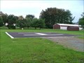 view gallery view galleryS12.1 km |  Helicopter Pad - Farmington Twp, Clarion County, Pennsylvania Helicopter Pad - Farmington Twp, Clarion County, Pennsylvania
in Helicopter Landing Pads This helicopter landing pad sits in a grassy field of a local community park. posted by: miatabug location: Pennsylvania date approved: 10/27/2008 last visited: 12/04/2011 |
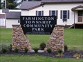 view gallery view galleryS12.1 km |  Farmington Township Community Park - Clarion County - Pennsylvania Farmington Township Community Park - Clarion County - Pennsylvania
in Municipal Parks and Plazas This new park in Clarion County contains a ballfield and playground equipment. posted by: miatabug location: Pennsylvania date approved: 10/27/2008 last visited: 12/04/2011 |
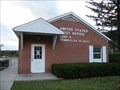 view gallery view galleryS12.4 km |  Leeper, Pennsylvania 16233 Leeper, Pennsylvania 16233
in U.S. Post Offices This stand alone post office serves the town of Leeper, Pennsylvania and surrounding communities. posted by: miatabug location: Pennsylvania date approved: 10/27/2008 last visited: 12/04/2011 |
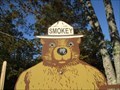
 view gallery view gallery E13 km E13 km
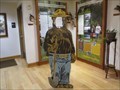
|  Interactive Smokey - Marienville, PA Interactive Smokey - Marienville, PA
in Smokey Bear Sign Sightings This Smokey is inside the Ranger Station. You can take a photo with him and he'll look like you. posted by: r.e.s.t.seekers location: Pennsylvania date approved: 11/06/2023 last visited: 11/27/2023 |
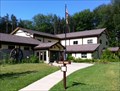 view gallery view galleryE13 km |  Allegheny National Forest - Marienville District Ranger Station - Marienville, Pennsylvania Allegheny National Forest - Marienville District Ranger Station - Marienville, Pennsylvania
in Ranger Stations The Marienvile District Ranger Station of Allegheny Natio" nal Forest is located at 131 Smokey Lane, off of State Route 66 in Jenks Township, Forest County, Pennsylvania posted by: outdoorboy34 location: Pennsylvania date approved: 10/18/2012 last visited: 11/09/2013 |
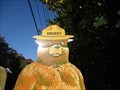 view gallery view galleryE13.2 km | Smokey twins - Route 66, Marienville, PA in Smokey Bear Sign Sightings This pair of Smokeys guard the Allegheny National Forest. posted by: r.e.s.t.seekers location: Pennsylvania date approved: 10/09/2023 last visited: 11/27/2023 |
 view gallery view galleryE13.2 km | Smokey at Ranger Station - Marienville, PA in Smokey Bear Sign Sightings This is a different style Smokey. posted by: r.e.s.t.seekers location: Pennsylvania date approved: 10/04/2023 last visited: 10/06/2023 |
 view gallery view galleryN14.2 km | North Country Trail - Forest Road 449 Trailhead - Forest County, PA in North Country Trail A trailhead for the NCT in the Allegheny National Forest in Forest County, PA posted by: jonathanatpsu location: Pennsylvania date approved: 08/01/2022 last visited: never |
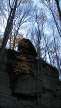 view gallery view gallery NE14.6 km NE14.6 km
|  Balanced Rock of Logan Falls - Marienville, Pennsylvania, USA Balanced Rock of Logan Falls - Marienville, Pennsylvania, USA
in Nature's Balanced Rocks Spotted while geocaching near Logan Falls. Logan Falls is located in the Allegheny National Forest (ANF) near Marionville, PA. posted by: ted28285 location: Pennsylvania date approved: 10/26/2023 last visited: 10/23/2023 |
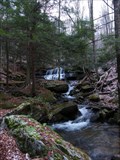 view gallery view galleryNE15.1 km |  Logans Falls Logans Falls
in Waterfalls Logans Falls is a small waterfalls in an isolated section of the Allegheny National Forest. posted by: miatabug location: Pennsylvania date approved: 11/29/2007 last visited: 01/17/2016 |
|