 view gallery view gallery SE28 km SE28 km
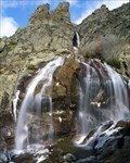
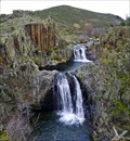
|   Cascada de los Litueros (o de Somosierra) Cascada de los Litueros (o de Somosierra)
in Waterfalls La cascada o chorrera de los Litueros pasa por ser la más alta de la Comunidad de Madrid. posted by:  monticola monticola location: Comunidad de Madrid, Spain date approved: 07/08/2008 last visited: 09/14/2019 |
 view gallery view gallery S30.9 km S30.9 km
|  Las Berrocosas Las Berrocosas
in Vértices Geodésicos Se encuentra en una de las cumbres secundarias de los montes Carpetanos que por poco no alcanza los 2000 metros. posted by: monticola location: Comunidad de Madrid, Spain date approved: 05/24/2011 last visited: 08/03/2010 |
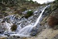
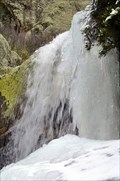
 view gallery view galleryS35.6 km | El Chorro de Navafría in Waterfalls La más conocida de las chorreras o chorrancas que abundan en los cursos de agua de la cara septentrional del Guadarrama. The best known of the many waterfalls that make up the watercourses of the northern face of the Guadarrama. posted by: monticola location: Castilla y León, Spain date approved: 02/02/2010 last visited: 07/25/2009 |
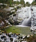
 view gallery view galleryS36 km | Chorrera de San Mamés in Waterfalls Una de las cascadas de mayor altura en la Comunidad de Madrid posted by: monticola location: Comunidad de Madrid, Spain date approved: 05/07/2008 last visited: never |
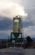
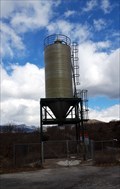 view gallery view gallerySE38.5 km |  M-137 Km12 - Prádena de Rincón, Madrid, España M-137 Km12 - Prádena de Rincón, Madrid, España
in Solitary Silos Silo de vialidad invernal // Winter road silo posted by:  xeocach xeocach location: Comunidad de Madrid, Spain date approved: 03/12/2023 last visited: never |
 view gallery view gallerySE38.9 km |  Laguna del Salmoral - Prádena del Rincón, Madrid, España Laguna del Salmoral - Prádena del Rincón, Madrid, España
in Birdwatching Locations Observatorio de aves en la Laguna del Salmoral // Bird observatory in the Salmoral Lake posted by: xeocach location: Comunidad de Madrid, Spain date approved: 08/13/2023 last visited: never |
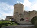
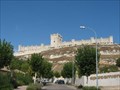 view gallery view gallery NW39.4 km NW39.4 km
|  Peñafiel Castle - Valladolid, Spain Peñafiel Castle - Valladolid, Spain
in Castles Peñafiel's castle adapts to the narrow and long hill on the one that settles itself in the locality of the same name, in the province of Valladolid, to 56 kilometres of his capital. posted by: jcast location: Castilla y León, Spain date approved: 11/12/2006 last visited: 04/01/2018 |
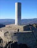
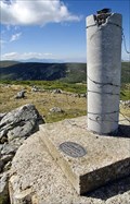
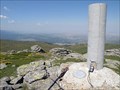
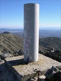
 view gallery view galleryS40.2 km | Pico del Nevero (Pinilla del Valle, Madrid) in Vértices Geodésicos Situado en la Sierra de Guadarrama, en el pico de Nevero, en terreno de rocas. posted by: jcast location: Spain date approved: 08/10/2008 last visited: 05/22/2011 |
 view gallery view gallerySE43.9 km | Peña de la Cabra in Vértices Geodésicos La Peña de la Cabra (1830m) forma un brusco resalte en la cuerda que se inicia en el puerto de la Puebla. posted by: monticola location: Spain date approved: 02/11/2008 last visited: never |
 view gallery view gallery W44.7 km W44.7 km
| Cuellar, Segovia, Spain in Castles Cuellar's castle isplaced in the Cuéllar's highest part, province of Segovia, closing for this place the enclosure walled of the villa. posted by: jcast location: Castilla y León, Spain date approved: 11/12/2006 last visited: 11/12/2006 |
 view gallery view galleryS45.9 km | A-1 km69 - Lozoyuela, Madrid, España in Solitary Silos Silo de vialidad invernal // Winter road silo posted by: xeocach location: Comunidad de Madrid, Spain date approved: 03/12/2023 last visited: never |
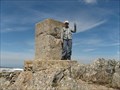
 view gallery view galleryS46.5 km | Flecha in Vértices Geodésicos El alto Flecha es una de las cumbres de la cuerda de los montes Carpetanos, situado casi a mitad de camino entre el puerto de Navafría y el pico de Peñalara. posted by: monticola location: Comunidad de Madrid, Spain date approved: 10/08/2013 last visited: never |
 view gallery view gallerySE47.5 km | La Tornera (Madrid) in Vértices Geodésicos Vértice situado en la máxima cota de la Sierra de la Puebla o del Lobosillo. posted by: monticola location: Spain date approved: 02/11/2008 last visited: never |
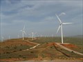 view gallery view gallery E48.1 km E48.1 km
|  Guadalajara-Segovia Guadalajara-Segovia
in Windmills These windmills are in a eolic Park between Guadalajara and Segovia in the roud N-110 posted by: jcast location: Spain date approved: 05/28/2006 last visited: never |
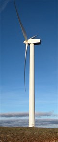 view gallery view galleryE48.8 km | Parque Eólico Cantalojas in Windmills Gran parque eólico situado en torno al alto de Rivilla (1506 m) posted by: monticola location: Spain date approved: 03/08/2009 last visited: never |
 view gallery view galleryE48.8 km | Rivilla (Guadalajara) in Vértices Geodésicos Situado en lo más alto del cerro del mismo nombre, sobre un terreno en el que hay un parque eolico, en el mojón límite de las provincias de Soria, Segovia y Guadalajara. posted by: jcast location: Spain date approved: 05/28/2006 last visited: never |
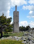
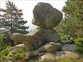 view gallery view galleryS49.6 km |  El Carro del Diablo El Carro del Diablo
in Nature's Balanced Rocks Un bloque de granito es el protagonista de una antigua leyenda. posted by: monticola location: Spain date approved: 06/30/2008 last visited: never |
 view gallery view galleryS49.6 km | Reventón (Rascafría, Madrid) in Vértices Geodésicos Vértice situado sobre el pico del mismo nombre (2080m) junto al puerto del Reventón, uno de los más transitados en épocas pasadas para salvar los Montes Carpetanos. posted by: monticola location: Spain date approved: 07/01/2008 last visited: never |
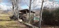
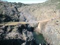 view gallery view gallerySE49.7 km |  Puente de Matallana Puente de Matallana
in Hiking Path Footbridges Puente sobre el río Jarama en el camino entre las localidades de Matallana y Roblelacasa (Guadalajara) posted by: monticola location: Spain date approved: 02/15/2009 last visited: never |
 view gallery view gallerySE50.1 km | Centenera (Madrid) in Vértices Geodésicos El pico Centenera (1809m) constituye el extremo sur de la sierra de la Puebla o del Lobosillo. posted by: monticola location: Spain date approved: 02/11/2008 last visited: never |
 view gallery view gallerySE50.4 km | Cascada del Aljibe in Waterfalls Una de las cascadas menos conocidas y a la vez más bonitas de Guadalajara posted by: monticola location: Castilla-La Mancha, Spain date approved: 02/15/2009 last visited: never |
 view gallery view galleryS50.4 km | Chorro Grande de San Ildefonso in Waterfalls Muy cerca del Real Sitio de La Granja el arroyo del Chorro Grande se precipita a lo largo de un gran desnivel granítico. Very close to the Real Sitio de La Granja, the stream of Chorro Grande rushes over a large granite slope. posted by: monticola location: Castilla y León, Spain date approved: 04/12/2011 last visited: never |
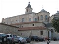 view gallery view galleryS50.7 km |  Real Monasterio de Santa María de El Paular - Rascafría, Spain Real Monasterio de Santa María de El Paular - Rascafría, Spain
in Abbeys, Convents and Monasteries El Paular monestry is located in the village of Rascafria, province of Madrid (Spain) posted by: jcast location: Comunidad de Madrid, Spain date approved: 09/04/2006 last visited: 10/01/2006 |
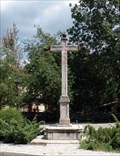 view gallery view galleryS50.9 km |  Cruz de El Paular Cruz de El Paular
in Christian Crosses Cruz de granito situada junto al monasterio de El Paular (Rascafría, Madrid) posted by: monticola location: Spain date approved: 07/01/2008 last visited: never |
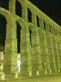 view gallery view gallery SW51.3 km SW51.3 km
|  The Roman Aqueduct in Segovia, Spain The Roman Aqueduct in Segovia, Spain
in Ancient Aqueducts Segovia's most unique feature is its still-functioning ancient aqueduct. It was built by the Romans around 50 AD, and is designed to make water flow uphill. (Don't ask how that works!) Even more amazing, Segovia's aqueduct was built without mortar. The pillars, and the arches, of the structure were built simply by stacking large stones. posted by: aerospacecase location: Castilla y León, Spain date approved: 09/08/2005 last visited: 03/22/2024 |
|