 view gallery view gallery W2.1 km W2.1 km
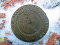
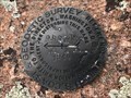
|   POLE (MO1232) - Albany County, Wyoming POLE (MO1232) - Albany County, Wyoming
in U.S. Benchmarks A USGS benchmark atop one of the high points of the Pole Mountain area on Medicine Bow National Forest. posted by:  Tom.dog Tom.dog location: Wyoming date approved: 11/21/2022 last visited: never |
 view gallery view gallery E3.2 km E3.2 km
| RUSSELL Azimuth Mark - Albany County, Wyoming in U.S. Benchmarks This is the azimuth mark for triangulation station RUSSELL (MO1220). posted by: Tom.dog location: Wyoming date approved: 06/25/2023 last visited: never |
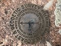
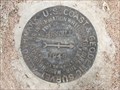 view gallery view galleryE3.2 km |  RUSSELL Azimuth Mark - Albany County, Wyoming RUSSELL Azimuth Mark - Albany County, Wyoming
in Azimuth Benchmarks The azimuth mark for triangulation station RUSSELL (MO1220). posted by: Tom.dog location: Wyoming date approved: 07/02/2023 last visited: never |
 view gallery view gallery N3.7 km N3.7 km
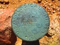
| 8287 DENVER (AA2129) - Albany County, Wyoming in U.S. Benchmarks A USGS pipe cap to the southeast of Forest Service Road 712 (Telephone Road). posted by: Tom.dog location: Wyoming date approved: 11/21/2022 last visited: never |
 view gallery view gallery NW3.7 km NW3.7 km
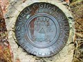
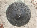
| BGRS 1 (MO1247) - Albany County, Wyoming in U.S. Benchmarks A USGS benchmark on the south side of Forest Service Road 712 (Telephone Road). posted by: Tom.dog location: Wyoming date approved: 11/21/2022 last visited: never |
 view gallery view galleryE4.3 km | RUSSELL NO 2 - Albany County, Wyoming in U.S. Benchmarks Reference mark 2 for triangulation station RUSSELL (MO1220). posted by: Tom.dog location: Wyoming date approved: 06/25/2023 last visited: never |
 view gallery view galleryE4.3 km | RUSSELL RM 1 (MO1221) - Albany County, Wyoming in U.S. Benchmarks Reference mark 1 for triangulation station RUSSELL (MO1220). posted by: Tom.dog location: Wyoming date approved: 06/25/2023 last visited: never |
 view gallery view galleryE4.3 km | RUSSELL (MO1220) - Albany County, Wyoming in U.S. Benchmarks This is a 1912 triangulation station on top of a granite knob in the Pole Mountain unit of Medicine Bow National Forest. posted by: Tom.dog location: Wyoming date approved: 06/25/2023 last visited: never |
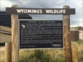
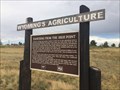 view gallery view galleryW5.5 km |  Ranching from the High Point - Laramie, WY Ranching from the High Point - Laramie, WY
in Wyoming Historical Markers This is one of a few markers at the I-80 rest area. posted by: bluesnote location: Wyoming date approved: 08/27/2014 last visited: 07/07/2017 |
 view gallery view galleryW5.5 km | Gateway to the Rockies - Laramie, WY in Wyoming Historical Markers This is one of a few markers at the I-80 rest area. posted by: bluesnote location: Wyoming date approved: 08/27/2014 last visited: 07/06/2017 |
 view gallery view galleryW5.5 km |  Gateway to the Rockies - Laramie, WY Gateway to the Rockies - Laramie, WY
in Lincoln Highway This is one of a few markers at the I-80 rest area. posted by: bluesnote location: Wyoming date approved: 11/09/2017 last visited: 11/09/2017 |
 view gallery view galleryW5.5 km |  FIRST -- Telephone Line in the West - Laramie, WY FIRST -- Telephone Line in the West - Laramie, WY
in First of its Kind This is one of a few markers at the I-80 rest area. posted by: bluesnote location: Wyoming date approved: 08/27/2014 last visited: 11/11/2017 |
 view gallery view galleryW5.5 km | Telephone Canyon - Laramie, WY in Wyoming Historical Markers This is one of a few markers at the I-80 rest area. posted by: bluesnote location: Wyoming date approved: 08/27/2014 last visited: 11/11/2017 |
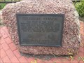
 view gallery view galleryW5.5 km |  Telephone Canyon - Laramie, WY, USA Telephone Canyon - Laramie, WY, USA
in Daughters of the American Revolution At the Summit Rest Area and Visitor Center 10 miles east of Laramie (Exit 323) near the colossal Abraham Lincoln Memorial Monument head you will find Telephone Canyon DAR marker on a large pink granite boulder. posted by: bluesnote location: Wyoming date approved: 01/13/2024 last visited: 02/06/2024 |
 view gallery view galleryW5.5 km | Telephone Canyon - Laramie, WY in Lincoln Highway This is one of a few markers at the I-80 rest area. posted by: bluesnote location: Wyoming date approved: 11/09/2017 last visited: 11/09/2017 |
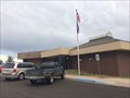
 view gallery view galleryW5.5 km |  Summit Visitor Information Center Museum - Laramie, WY Summit Visitor Information Center Museum - Laramie, WY
in History Museums There is a small museum inside the visitor center that takes about the history of Albany County. posted by: bluesnote location: Wyoming date approved: 03/24/2016 last visited: 03/24/2016 |
 view gallery view galleryW5.5 km |  Summit Visitor Information Center - Laramie, WY Summit Visitor Information Center - Laramie, WY
in Bookcrossing Zones A visitor center at a rest area at the highest most point along the Lincoln Highway and Interstate 80. posted by: bluesnote location: Wyoming date approved: 03/12/2016 last visited: 03/12/2016 |
 view gallery view galleryW5.5 km |  Summit Visitor Information Center - Laramie, WY Summit Visitor Information Center - Laramie, WY
in Free Overnight RV Parking Locations A visitor center at a rest area at the highest most point along the Lincoln Highway and Interstate 80. posted by: bluesnote location: Wyoming date approved: 02/20/2016 last visited: 02/20/2016 |
 view gallery view galleryW5.5 km |  Summit Visitor Information Center - Laramie, WY Summit Visitor Information Center - Laramie, WY
in Tourist Information Centers - Visitor Centers A visitor center at a rest area at the highest most point along the Lincoln Highway and Interstate 80. posted by: bluesnote location: Wyoming date approved: 08/28/2014 last visited: 08/28/2014 |
 view gallery view galleryW5.5 km |  Dbits About Wyoming Map - Laramie, WY Dbits About Wyoming Map - Laramie, WY
in 'You Are Here' Maps This is one of a few maps inside the Summit Visitor Center. posted by: bluesnote location: Wyoming date approved: 08/28/2014 last visited: 08/28/2014 |
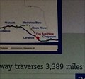 view gallery view galleryW5.5 km | Lincoln Highway Map - Laramie, WY in 'You Are Here' Maps This is one of a few maps inside the Summit Visitor Center. posted by: bluesnote location: Wyoming date approved: 08/28/2014 last visited: 07/06/2017 |
 view gallery view galleryW5.5 km | Some Tips Map - Laramie, WY in 'You Are Here' Maps This is one of a few maps inside the Summit Visitor Center. posted by: bluesnote location: Wyoming date approved: 08/28/2014 last visited: 08/28/2014 |
 view gallery view galleryW5.5 km | Summit Info Center Visitor Log - Laramie, WY in Guest Books A visitor center at a rest area at the highest most point along the Lincoln Highway and Interstate 80. posted by: bluesnote location: Wyoming date approved: 10/27/2014 last visited: 10/27/2014 |
 view gallery view galleryW5.5 km | Lincoln Highway Post - Laramie, WY in Lincoln Highway Markers This wooden post from the lincoln Highway is on display at a visitor center along the actual highway. posted by: bluesnote location: Wyoming date approved: 08/27/2014 last visited: 07/06/2017 |
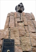 view gallery view galleryW5.5 km | Highest Point on Lincoln Highway - Laramie, WY in Lincoln Highway The rest area has a monument to the first president of the Lincoln Highway Association, and a large bust of Lincoln. posted by:  ronjean ronjean location: Wyoming date approved: 05/22/2009 last visited: 03/22/2022 |
|