 view gallery view gallery SE5.8 km SE5.8 km
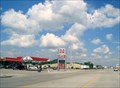
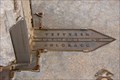
|   Small Town USA Small Town USA
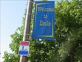
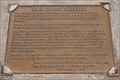
in Lincoln Highway Markers Highway in Brule, Nebraska posted by:  TonyGlo TonyGlo location: Nebraska date approved: 09/26/2005 last visited: 06/30/2022 |
 view gallery view gallery SW6.3 km SW6.3 km
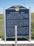
|  California Hill # 313 California Hill # 313
in Nebraska Historical Markers Marker about a hill on the way to the North Platte River. posted by:  Biker Ozzy Biker Ozzy location: Nebraska date approved: 09/16/2009 last visited: 06/18/2007 |
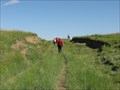 view gallery view gallerySW6.3 km |  California Hill - Brule, Nebraska California Hill - Brule, Nebraska
in U.S. National Register of Historic Places California Hill was climbed by thousands of westward emigrants heading west during the covered wagon migrations from 1841-1860. posted by: Rose Red location: Nebraska date approved: 01/06/2010 last visited: never |
 view gallery view gallerySW14.5 km | SAM BASS AND THE BIG SPRINGS ROBBERY in Nebraska Historical Markers Sam Bass and his gang robbed the Union Pacific train of $60,000 on September 18, 1877. posted by: plainsdrifter358 location: Nebraska date approved: 05/14/2008 last visited: 01/12/2013 |
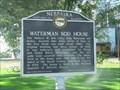 view gallery view gallerySW14.5 km | Waterman Sod House in Nebraska Historical Markers Sod house built about 1886 and lived in until 1989! posted by: plainsdrifter358 location: Nebraska date approved: 05/14/2008 last visited: 01/12/2013 |
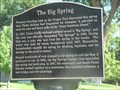 view gallery view gallerySW14.6 km | The Big Spring in Nebraska Historical Markers Spring used by Plains Indians for centuries was disovered by Oregon Trail pioneers. posted by: plainsdrifter358 location: Nebraska date approved: 05/14/2008 last visited: 09/02/2007 |
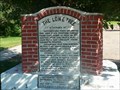 view gallery view gallerySW14.6 km | The Lone Tree in Nebraska Historical Markers Largest tree from Omaha to Denver. posted by: plainsdrifter358 location: Nebraska date approved: 05/14/2008 last visited: 01/13/2013 |
 view gallery view gallery E16.6 km E16.6 km
| Samuel David 'Lep' Sanders in Nebraska Historical Markers On US 26 at West 'O' St in Ogallala. posted by: Markerman62 location: Nebraska date approved: 03/22/2015 last visited: 03/11/2015 |
 view gallery view galleryE17.1 km |  A&W - Ogallala, Nebraska A&W - Ogallala, Nebraska
in A + W Restaurants This A&W is attached to a gas station. posted by: SageInThyme82 location: Nebraska date approved: 09/30/2015 last visited: 07/31/2023 |
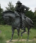 view gallery view galleryE17.4 km |  Trail Boss - Ogallala, Nebraska Trail Boss - Ogallala, Nebraska
in Equestrian Statues Sitting high above Ogallala in a pioneer cemetery is this statue commemorating the Texas Trail. posted by: gparkes location: Nebraska date approved: 02/02/2010 last visited: 02/22/2022 |
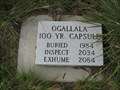 view gallery view galleryE17.4 km |  Ogallala 100 Yr. Capsule, Nebraska Ogallala 100 Yr. Capsule, Nebraska
in Time Capsules Ogallala 100 Yr. Capsule was buried in 1984 in Boot Hill Cemetery. posted by: Rose Red location: Nebraska date approved: 07/04/2007 last visited: 08/04/2007 |
 view gallery view galleryE17.4 km | Boot Hill, Ogallala, Nebraska in Nebraska Historical Markers Most, especially the cowboys, were buried with their boots on, thus the name Boot Hill. posted by: Rose Red location: Nebraska date approved: 07/29/2007 last visited: 02/22/2022 |
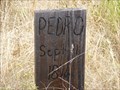 view gallery view galleryE17.4 km |  Pedro - Boot Hill Cemetery - Ogallala NE Pedro - Boot Hill Cemetery - Ogallala NE
in Homemade Tombstones PEDRO Sept 1 1876-Homemade tombstone in Boot Hill Cemetery, Ogallala NE. posted by: Don.Morfe location: Nebraska date approved: 03/21/2022 last visited: 02/22/2022 |
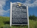
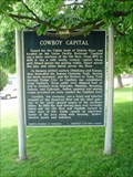 view gallery view galleryE17.7 km | Cowboy Capital # 5 in Nebraska Historical Markers Marker by Mansion on the Hill Museum posted by: Biker Ozzy location: Nebraska date approved: 08/23/2008 last visited: 02/22/2022 |
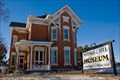 view gallery view galleryE17.9 km | Brandhoefer, Leonidas A., Mansion - Ogallala, NE in U.S. National Register of Historic Places Also known as the "Mansion on the Hill," this elegant brick manor was built in 1887 and added to the National Register of Historic Places in 1973. posted by: IJAdventures location: Nebraska date approved: 02/09/2013 last visited: never |
 view gallery view galleryE17.9 km |  Mansion on the Hill - Ogallala, NE Mansion on the Hill - Ogallala, NE
in Ghosts and Hauntings Strange lights and a shadowy figure haunt this 1880's era mansion. posted by: IJAdventures location: Nebraska date approved: 02/09/2013 last visited: never |
 view gallery view gallerySW17.9 km | Four Counties: Keith County, NE in Nebraska Historical Markers Keith County is located northeast of the corner of Colorado. posted by: IJAdventures location: Nebraska date approved: 09/20/2013 last visited: 05/25/2022 |
 view gallery view gallerySW17.9 km | Four Counties: Deuel County, NE in Nebraska Historical Markers Deuel County is located northwest of the corner of Colorado. posted by: IJAdventures location: Nebraska date approved: 09/20/2013 last visited: 05/25/2022 |
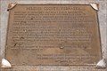
 view gallery view gallerySW17.9 km |  Where Colorado Meets the Pan & Handle of Nebraska Where Colorado Meets the Pan & Handle of Nebraska
in U.S. Historic Survey Stones and Monuments The Waymark is at Benchmark MN0401, which is a horizontal control disk (brass) set in the top of a sculpted boulder, at the north-east corner of Colorado and the south-east corner of the Nebraska panhandle. posted by: DuneStalker location: Colorado date approved: 07/27/2010 last visited: 08/07/2023 |
 view gallery view gallerySW17.9 km |  NORTHEAST CORNER COLORADO (MN0401) - Sedgwick County, CO NORTHEAST CORNER COLORADO (MN0401) - Sedgwick County, CO
in U.S. Benchmarks This horizontal control disk marks the northeast corner of Colorado and Nebraska. posted by: IJAdventures location: Colorado date approved: 09/13/2013 last visited: 05/25/2022 |
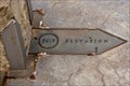 view gallery view gallerySW17.9 km |  3613 Feet - Corner of Colorado & Nebraska 3613 Feet - Corner of Colorado & Nebraska
in Elevation Signs The elevation where the northeast corner of Colorado meets the panhandle of Nebraska. posted by: IJAdventures location: Nebraska date approved: 09/16/2013 last visited: 05/25/2022 |
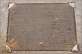
 view gallery view gallerySW17.9 km |  N 41°00' W 102°03' - Corner of Colorado & Nebraska N 41°00' W 102°03' - Corner of Colorado & Nebraska
in Permanent Geographic Coordinates These coordinates are listed on a monument at the northeast corner of Colorado. posted by: IJAdventures location: Colorado date approved: 09/16/2013 last visited: 05/25/2022 |
 view gallery view gallerySW17.9 km | Four Counties: Perkins County, NE in Nebraska Historical Markers Perkins County is located southeast of the corner of Colorado. posted by: IJAdventures location: Nebraska date approved: 09/20/2013 last visited: 05/25/2022 |
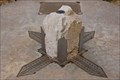
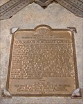 view gallery view gallerySW17.9 km |  Colorado's Northeast Corner - Sedgwick County, CO Colorado's Northeast Corner - Sedgwick County, CO
in Colorado Historical Markers This bronze plaque is located at the northeast corner of Colorado and Nebraska. posted by: IJAdventures location: Colorado date approved: 09/21/2013 last visited: 05/25/2022 |
 view gallery view gallerySW17.9 km | Four Counties: Sedgwick County, CO in Colorado Historical Markers Sedgwick County is the northeasternmost county in Colorado bordering Nebraska on two sides. posted by: IJAdventures location: Colorado date approved: 09/21/2013 last visited: 05/25/2022 |
|