 view gallery view gallery S4 km S4 km
|   Strawberry Creek - California Strawberry Creek - California
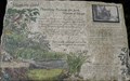
in Signs of History History sign at Strawberry Creek bridge at Clam Beach County Park, McKinleyville, CA. posted by:  Volcanoguy Volcanoguy location: California date approved: 02/13/2014 last visited: 04/13/2016 |
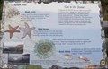
 view gallery view galleryS4 km |  Strawberry Creek - California Strawberry Creek - California
in Flora and Fauna Information Signs Flora and Fauna sign at Strawberry Creek bridge at Clam Beach County Park, McKinleyville, CA. posted by: Volcanoguy location: California date approved: 02/12/2014 last visited: 02/16/2021 |
  NW4.2 km NW4.2 km
|  Tsurai Tsurai
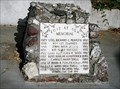
in California Historical Markers Pre-contact Yurok Village Site first discovered by Europeans in the 18th century. posted by: Viking Goat location: California date approved: 11/27/2006 last visited: 03/06/2021 |
 view gallery view galleryNW4.2 km |  Lost At Sea Memorial, Trinidad, California Lost At Sea Memorial, Trinidad, California
in Maritime Monuments and Memorials Memorial for those lost at sea at the Trinidad Memorial Lighthouse. posted by:  Bernd das Brot Team Bernd das Brot Team location: California date approved: 09/22/2008 last visited: 03/06/2021 |
NW4.2 km | Trinidad Head in California Historical Markers Spaniards claim Trinidad Head for Spain in 1775. posted by: Viking Goat location: California date approved: 11/27/2006 last visited: 08/08/2007 |
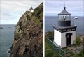 view gallery view galleryNW4.2 km |  Trinidad Head & Point Trinidad Head Memorial Lighthouse Trinidad Head & Point Trinidad Head Memorial Lighthouse
in Coastal Lighthouses What you see marked in the map is a replica in the center of Trinidad. The real thing is on the ocean-facing side and is really hard to see. posted by: Bernd das Brot Team location: California date approved: 05/26/2006 last visited: 12/04/2021 |
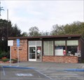
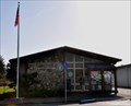 view gallery view galleryNW4.3 km |  Trinidad, California 95570 Trinidad, California 95570
in U.S. Post Offices This Post Office is located at 357 Main Street in Trinidad, California. posted by: brwhiz location: California date approved: 01/01/2012 last visited: never |
NW4.3 km | Town of Trinidad in California Historical Markers Trinidad is the oldest European town on the north coast of California. posted by: Viking Goat location: California date approved: 11/27/2006 last visited: 03/06/2021 |
 view gallery view galleryNW4.5 km |  Trinidad, California ~ Elevation 175 Feet Trinidad, California ~ Elevation 175 Feet
in Elevation Signs This combination Population/Elevation Sign is on the west side of the US Highway 101 Exit 728 southbound offramp as you enter Trinidad from the north. posted by: brwhiz location: California date approved: 12/13/2012 last visited: 06/05/2020 |
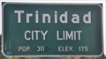 view gallery view galleryNW4.5 km |  Trinidad, California ~ Population 311 Trinidad, California ~ Population 311
in Population Signs This combination Population/Elevation Sign is on the west side of the US Highway 101 Exit 728 southbound offramp as you enter Trinidad from the north. posted by: brwhiz location: California date approved: 12/13/2012 last visited: 06/04/2020 |
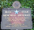 view gallery view galleryNW7.6 km |  Rest Area along Highway 101, near Trinidad, CA Rest Area along Highway 101, near Trinidad, CA
in Blue Star Memorial Highway Markers This Blue Star Memorial Highway Marker is found at a Highway 101 Rest Area. posted by: Mauison location: California date approved: 07/29/2007 last visited: 09/14/2012 |
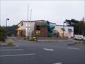
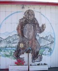 view gallery view galleryS8.2 km |  Bigfoot, McKinleyville, CA Bigfoot, McKinleyville, CA
in Murals Bigfoot is, where else, but at Bigfoot Gas Station posted by: CraigInCT location: California date approved: 08/04/2008 last visited: 09/23/2012 |
 view gallery view galleryS8.2 km |  Bigfoot, McKinleyville, CA Bigfoot, McKinleyville, CA
in Epic Beings and Creatures Bigfoot's Gas Station posted by: CraigInCT location: California date approved: 08/04/2008 last visited: 09/23/2012 |
 view gallery view galleryS9.7 km | McKinleyville, California 95519 in U.S. Post Offices This Post Office is located at 1561 City Center Road in McKinleyville, California. posted by: brwhiz location: California date approved: 01/01/2012 last visited: never |
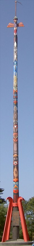 view gallery view galleryS9.7 km |  Totem Pole, McKinleyville, CA Totem Pole, McKinleyville, CA
in Outside Wooden Display Carvings (No longer) The Tallest Totem Pole in the World posted by: CraigInCT location: California date approved: 08/04/2008 last visited: 05/04/2015 |
 view gallery view galleryS10.9 km |  Anna Sparks Way McDonalds - McKinleyville, Ca Anna Sparks Way McDonalds - McKinleyville, Ca
in McDonald's Restaurants A nice modern looking McDonalds with a nice multi level outdoor playplace in McKinleyville, Ca. posted by: frivlas location: California date approved: 09/10/2006 last visited: 04/18/2011 |
S11.3 km |  Unknown McKinnleyville Falls Unknown McKinnleyville Falls
in Waterfalls a nice set of falls right off the main raod in McKinleyville posted by: Phobos+Demos location: California date approved: 01/27/2006 last visited: 01/19/2012 |
S11.6 km |  Six Rivers Brew Six Rivers Brew
in Brewpubs This pub is in McKinleyville, Ca posted by: Phobos+Demos location: California date approved: 01/27/2006 last visited: 03/25/2013 |
 view gallery view gallery N11.9 km N11.9 km
| Palmers Point South - Patrick’s Point S.P. - California in Flora and Fauna Information Signs South group of signs at Palmers Point. posted by: Volcanoguy location: California date approved: 02/02/2014 last visited: 04/12/2023 |
 view gallery view galleryN11.9 km | Palmers Point North - Patrick’s Point S.P. - California in Flora and Fauna Information Signs North group of signs at Palmers Point. posted by: Volcanoguy location: California date approved: 02/02/2014 last visited: 09/22/2013 |
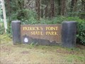 view gallery view galleryN12.1 km |  Patrick’s Point State Park - California Patrick’s Point State Park - California
in State/Provincial Parks Patrick’s Point State Park on the northern California Coast, 25 miles north of Eureka and 56 miles south of Crescent City. posted by: Volcanoguy location: California date approved: 01/30/2014 last visited: 04/12/2023 |
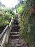 view gallery view galleryN12.7 km |  Ceremonial Rock Stairs - Patrick’s Point State Park - California Ceremonial Rock Stairs - Patrick’s Point State Park - California
in Outdoor Stairways Stairway to top of Ceremonial Rock in Patrick’s Point State Park. posted by: Volcanoguy location: California date approved: 02/04/2014 last visited: 09/22/2013 |
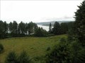 view gallery view galleryN12.7 km |  Ceremonial Rock - Patrick’s Point State Park - California Ceremonial Rock - Patrick’s Point State Park - California
in Scenic Overlooks Ceremonial Rock Overlook in Patrick’s Point State Park. posted by: Volcanoguy location: California date approved: 02/01/2014 last visited: 09/22/2013 |
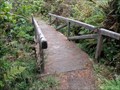 view gallery view galleryN12.7 km |  Footbridge - Rocky Point Trail - Patrick’s Point S.P. - California Footbridge - Rocky Point Trail - Patrick’s Point S.P. - California
in Hiking Path Footbridges Footbridge on Rocky Point Trail. posted by: Volcanoguy location: California date approved: 02/01/2014 last visited: 09/22/2013 |
 view gallery view galleryN12.9 km |  LV1165 - NGS PIN 1927 NO 2 1974 - California LV1165 - NGS PIN 1927 NO 2 1974 - California
in U.S. Benchmarks National Geodetic Survey reference mark for LV1165. posted by: Volcanoguy location: California date approved: 02/01/2014 last visited: 11/20/2023 |
|