 view gallery view gallery S1.8 km S1.8 km
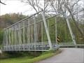
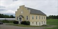
|   Negley Iron Whipple truss - Columbiana Co, Ohio Negley Iron Whipple truss - Columbiana Co, Ohio
in Truss Bridges Negley Iron Whipple truss bridge (SFN 1530291) over North Fork Little Beaver Creek in Columbiana County, Ohio posted by:  buffalohiker buffalohiker location: Ohio date approved: 05/03/2010 last visited: 04/29/2010 |
 view gallery view galleryS3.5 km |  Martin Luther King, Jr. Memorial - Mansfield, OH Martin Luther King, Jr. Memorial - Mansfield, OH
in Statues of Historic Figures This is a statue/memorial dedicated on June 15, 2007 in a park in downtown Mansfield, OH. This memorial has a larger than life bust of MLK and a granite monument with the words to his last public speech. posted by:  BluegrassCache BluegrassCache location: Ohio date approved: 11/10/2007 last visited: never |
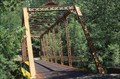
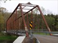 view gallery view galleryS4 km | Pancake Clarkson Rd Pratt through-truss - Columbiana Co, Ohio in Truss Bridges Pancake Clarkson Rd Pratt through-truss bridge (SFN 1538209) over North Fork Little Beaver Creek in Columbiana County, Ohio posted by: buffalohiker location: Ohio date approved: 05/03/2010 last visited: 04/29/2010 |
  SE4.3 km SE4.3 km
|  White Thorn Lodge - Darlington, PA White Thorn Lodge - Darlington, PA
in Nude Beaches This is a fun, safe, and family friendly camp. posted by: r.e.s.t.seekers location: Pennsylvania date approved: 06/20/2021 last visited: never |
 view gallery view gallery N4.7 km N4.7 km
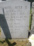
|  Samuel Meek II Samuel Meek II
in American Revolutionary War Veteran Graves Boatman Cemetery is fenced off and a gate is kept locked due to vandals disturbing the old gravestones. A key needs to requested from the East Palestine Police Station to gain entrance. East Palestine is in Columbiana County, Ohio. posted by: SerenityNow location: Ohio date approved: 06/27/2010 last visited: never |
 view gallery view galleryN4.7 km | Barnerd Boatman in American Revolutionary War Veteran Graves The gravestone reads Barnerd, but common spelling would suggest Bernard. Internet searches give both results so we'll assume that the tombstone engraver made no mistake and list him as Barnerd. This grave lies in East Palestine, Ohio. posted by: SerenityNow location: Ohio date approved: 06/27/2010 last visited: never |
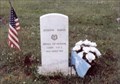 view gallery view galleryN4.7 km | Joseph Davis-East Palestine, OH in Medal Of Honor Resting Places Civil War Medal of Honor Recipient for action at Franklin TN on November 30, 1864. He is buried in Boatman Memorial Cemetery, East Palestine, OH. posted by: Don.Morfe location: Ohio date approved: 08/07/2018 last visited: 12/10/2021 |
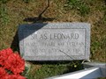 view gallery view galleryN4.7 km | Silas Leonard in American Revolutionary War Veteran Graves Silas Leonard's grave lies in Boatman Memorial Cemetery in East Palestine, Ohio in Columbiana County. Due to problems with vandalism, a key is required to gain access to the fenced-off cemetery. Go to the East Palestine Police station for the key. posted by: SerenityNow location: Ohio date approved: 06/27/2010 last visited: never |
 view gallery view gallery SW4.8 km SW4.8 km
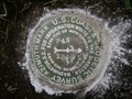
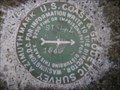
|  PAN AZ MK - Ohio PAN AZ MK - Ohio
in Azimuth Benchmarks This is the azimuth mark for station PAN, in Middleton Township, Columbiana County.
posted by: shorbird location: Ohio date approved: 08/11/2008 last visited: never |
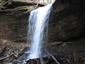 view gallery view galleryS5 km |  Sheepskin Hollow Nature Preserve, Lower Falls, Columbiana County, Ohio Sheepskin Hollow Nature Preserve, Lower Falls, Columbiana County, Ohio
in Waterfalls The lower falls is located approximately 1/4 mile up the hollow from the Sheepskin Hollow sign on the railroad bed.
Sorry, but no pets are allowed in the Nature Preserve. posted by: buckeyealum location: Ohio date approved: 01/24/2008 last visited: 04/29/2010 |
 view gallery view galleryN7.4 km |  Unity Grange Hall 1761 - Unity Ohio Unity Grange Hall 1761 - Unity Ohio
in Grange Halls Unity Grange Hall is on North Market Street posted by: lp5324 location: Ohio date approved: 08/23/2008 last visited: never |
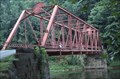
 view gallery view galleryS8.4 km | Fredericktown Bridge - Columbiana Co, Ohio in Truss Bridges Fredericktown Iron Pratt Through Truss Bridge (SFN 1535501) on Midland Fredericktown Road (TR 1038) over North Fork Little Beaver Creek in Columbiana County, Ohio. posted by: buffalohiker location: Ohio date approved: 05/20/2010 last visited: 01/17/2004 |
 view gallery view gallery W8.9 km W8.9 km
| SIGNAL AZ MK - Ohio in Azimuth Benchmarks This is the azimuth mark for station SIGNAL, in Elkrun Township,
Columbiana County. posted by: shorbird location: Ohio date approved: 08/11/2008 last visited: never |
 view gallery view gallerySW9.2 km | Echo Dell Bridge - Columbiana Co, Ohio in Truss Bridges Echo Dell Iron Pratt Through Truss Bridge (SFN 1537741) on Echo Dell Road (TR 929) over Little Beaver Creek in Beaver Creek State Park, Columbiana County, Ohio. posted by: buffalohiker location: Ohio date approved: 05/20/2010 last visited: 05/25/2016 |
 view gallery view gallerySW9.3 km |  Thomas J. Malone Bridge (Covered Bridge) Thomas J. Malone Bridge (Covered Bridge)
in Covered Bridges The Thomas J. Malone Bridge is a 42 foot long covered bridge that spans a small stream on Echo Dell Road in Beaver Creek State Park, Columbiana County, Ohio. posted by: Red Shoe & The Navigator location: Ohio date approved: 09/11/2006 last visited: 09/12/2018 |
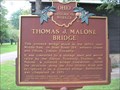 view gallery view gallerySW9.3 km |  Thomas J. Malone Bridge (Ohio Historical Marker) Thomas J. Malone Bridge (Ohio Historical Marker)
in Ohio Historical Markers Ohio State Historical Marker located on Echo Dell Road in Beaver Creek State Park, Columbiana County, Ohio, commemorating the Thomas J. Malone Bridge. posted by: Red Shoe & The Navigator location: Ohio date approved: 09/11/2006 last visited: 05/20/2016 |
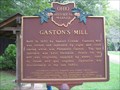 view gallery view gallerySW9.3 km | Gaston's Mill in Ohio Historical Markers Ohio State Historical Marker located on Echo Dell Road in Beaver Creek State Park, Columbiana County, Ohio, commemorating the Gaston’s Mill. posted by: Red Shoe & The Navigator location: Ohio date approved: 09/12/2006 last visited: 05/20/2016 |
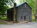 view gallery view gallerySW9.3 km |  Gaston's Mill - Beaver Creek State Park, Ohio Gaston's Mill - Beaver Creek State Park, Ohio
in Water Mills Gaston's Mill was constructed around 1830 by Samuel Conkle. Operation ceased in the 1920s. It is now maintained as a museum by Beaver Creek State Park, Ohio. posted by: buffalohiker location: Ohio date approved: 06/01/2016 last visited: 05/20/2016 |
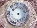 view gallery view gallerySW9.3 km |  Beaver Creek State Park Boundry Marker Beaver Creek State Park Boundry Marker
in Public Land Survey Marks Boundary Marker located in the Beaver Creek State Reservation. posted by: Whistlen location: Ohio date approved: 07/31/2009 last visited: never |
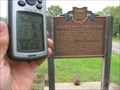 view gallery view gallerySW9.5 km | The Death of Pretty Boy Floyd in Ohio Historical Markers This is the Pretty Boy Floyd Historical Marker (#10-15) near Rogers, OH. In these fields in 1934, Charles Arthur "Pretty Boy" Floyd, a nortorious bank robber, was finally chased down and killed. posted by: B n J location: Ohio date approved: 02/14/2006 last visited: 03/17/2018 |
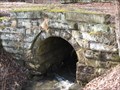 view gallery view gallerySW9.7 km |  Beaver Creek Stone Arch Bridge Beaver Creek Stone Arch Bridge
in Arch Bridges Located alongside of Leslie Rd., where it intersects Carlisle Rd., traveling to Beaver Creek State Park. It is at the bottom of hill, after passing the campground entrance. posted by: buckeyealum location: Ohio date approved: 01/04/2009 last visited: 06/29/2011 |
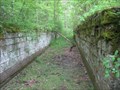 view gallery view gallerySW9.7 km |  Sandy and Beaver Canal Lock 39 Sandy and Beaver Canal Lock 39
in Waterway Locks, Planes and Lifts Lock 39, Eastern Division of the Sandy and Beaver Canal. Vondergreen Trail, Beaver Creek State Park, Columbiana Co. posted by: buckeyealum location: Ohio date approved: 02/15/2009 last visited: 06/15/2009 |
 view gallery view gallerySW10 km | Sandy & Beaver Canal Lock 38 in Waterway Locks, Planes and Lifts Lock 38, also known as Vondergreens, is perfectly preserved, without a stone missing. On the 'left' bank of Little Beaver Creek, Vondergreen Trail, Beaver Creek State Park, Columbiana Co., mile 15 of the Canal's Eastern Division. posted by: buckeyealum location: Ohio date approved: 02/09/2009 last visited: 06/05/2010 |
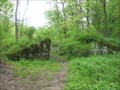
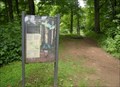 view gallery view gallerySW10.3 km |  North Country Trail, Beaver Creek State Park, Ohio North Country Trail, Beaver Creek State Park, Ohio
in 'You Are Here' Maps Sign at the trail head of North Country Trail, eastern side of the park posted by: sherpes location: Ohio date approved: 07/27/2009 last visited: never |
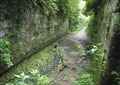 view gallery view gallerySW10.3 km | Sandy and Beaver Canal Lock 41, "Gretchen's Lock" in Waterway Locks, Planes and Lifts Built in the early 1800s posted by: sherpes location: Ohio date approved: 07/17/2009 last visited: 06/15/2009 |
|