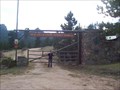
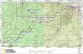
 view gallery view gallery NE8.2 km NE8.2 km
|   Ben Delatour Scout Ranch Ben Delatour Scout Ranch
in Boy Scout Camps BDSR offers Rocky Mountain camping Adventure on 3400 acres northwest of Fort Collins, CO. posted by:  Cuautemoc Cuautemoc location: Colorado date approved: 01/07/2006 last visited: 07/27/2012 |
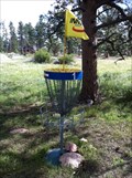 view gallery view galleryNE10.3 km |  Sundance Trail Ranch DGC - Red Feather Lakes, CO Sundance Trail Ranch DGC - Red Feather Lakes, CO
in Disc Golf Courses This disc golf course is located on a dude ranch, over 8,000 feet high on the Colorado Rockies east of Fort Collins. posted by: DougK location: Colorado date approved: 09/03/2011 last visited: never |
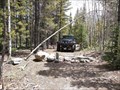
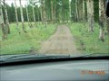 view gallery view gallery SE10.5 km SE10.5 km
|  Monument Gulch Trail Monument Gulch Trail
in Offroad Trails Monument Gulch Trailhead posted by:  KingJR KingJR location: Colorado date approved: 01/17/2006 last visited: never |
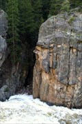
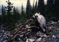 view gallery view gallery SW10.6 km SW10.6 km
|  Crown Point B-17 Crash Crown Point B-17 Crash
in Plane Crash Sites Wreckage of the 1944 "Crown Point" area B-17. posted by: KingJR location: Colorado date approved: 11/26/2005 last visited: 08/09/2014 |
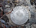
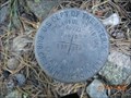
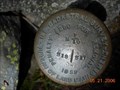 view gallery view gallery S13.8 km S13.8 km
|  Beaver Creak BLM Cadastral Survey Disk Beaver Creak BLM Cadastral Survey Disk
in U.S. Benchmarks BLM Cadastral Survey Disk. posted by: KingJR location: Colorado date approved: 05/21/2006 last visited: never |
 view gallery view galleryS14.6 km | Trail 234 - Pingree Park Area in Offroad Trails Un-named trail #234 near Pingree Park Colorado posted by: KingJR location: Colorado date approved: 01/01/2016 last visited: never |
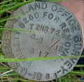 view gallery view gallerySE16.4 km | Greer Land Office Survey Disk in U.S. Benchmarks US General Land Office Survey Disk, stamped 1961 posted by: KingJR location: Colorado date approved: 08/06/2006 last visited: never |
 view gallery view galleryS17.7 km | B17 near Pingree Park, CO in Plane Crash Sites Boeing B17 Flying Fortress that crashed October 19, 1943. posted by: supradave location: Colorado date approved: 10/24/2005 last visited: 07/13/2006 |
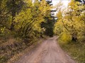
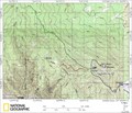
 view gallery view gallery E19.8 km E19.8 km
|  Youngs Gulch Youngs Gulch
in Scenic Hikes A nice hike that overlooks the stove prarie road when you reach the summit. posted by: KingJR location: Colorado date approved: 07/03/2007 last visited: 09/30/2011 |
 view gallery view gallery W20 km W20 km
|  Guardian of the Falls Guardian of the Falls
in Simulacra Guardian of the Falls. A profile of a Trojan Warrior keeping guard over the water fall. posted by: CacheKamm location: Colorado date approved: 06/22/2011 last visited: never |
 view gallery view gallerySE21.1 km | Old Flowers Road in Offroad Trails Old Flowers Road - Scenic area posted by: KingJR location: Colorado date approved: 01/17/2006 last visited: 08/24/2009 |
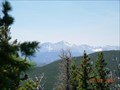
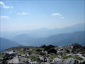
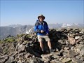
 view gallery view gallerySE21.9 km |  Crystal Mountain Crystal Mountain
in Mountain Summits Summit of Crystal Mountain, in Buckhorn Canyon - Larimer County, CO. posted by: KingJR location: Colorado date approved: 11/24/2005 last visited: never |
 view gallery view gallerySE22.4 km | Crystal Mountain 4x4 area in Offroad Trails This is the crystal mountain 4x4 area. posted by: KingJR location: Colorado date approved: 01/17/2006 last visited: never |
 view gallery view gallerySE24.5 km | Moody Hill 4x4 area in Offroad Trails Moody hill 4x4 area posted by: KingJR location: Colorado date approved: 01/17/2006 last visited: 06/28/2012 |
 SE24.6 km | Crystal Mountain unknown U.S.G.S. Benchmark in U.S. Benchmarks Stumbled upon this benchmark while ATVing Crystal Mountain back in August. posted by: KingJR location: Colorado date approved: 11/25/2005 last visited: never |
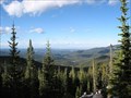
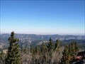
 view gallery view galleryS26.6 km | Bulwark Ridge Trail in Scenic Hikes A wonderful hike on top of Bulwark Ridge that takes you to the summit of South Signal Mountain. posted by: KingJR location: Colorado date approved: 07/03/2007 last visited: 05/11/2010 |
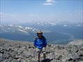 view gallery view galleryS28.2 km | Mt. Ypsilon in Mountain Summits Unbelievable views from the Ypsilon summit. Great look at the Never Summer Range, Longs Peak, Estes Valley. The list is too long to put here. posted by: Flying Cacher location: Colorado date approved: 07/18/2006 last visited: 06/18/2010 |
 view gallery view galleryE28.6 km | ") GeoCache La Poudre GeoCache La Poudre
in Waymark Tours (WayTours) GeoCache La Poudre is a virtual geocache course along the Cache La Poudre River sponsored by the City of Fort Collins Natural Areas Program. Answer 15+ questions and turn in the brochure (web address below) to be entered into a prize drawing. posted by: geocachelapoudre location: Colorado date approved: 08/04/2009 last visited: never |
 view gallery view galleryS29 km | Rocky Mountain National Park Sheep Mountain 9796 in U.S. Benchmarks At the top of Sheep Mountain Peak 9796 in Rocky Mountain National Park posted by: AlanC location: Colorado date approved: 10/24/2010 last visited: never |
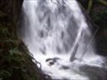 view gallery view galleryS29.5 km |  Bridal Veil Falls Bridal Veil Falls
in Waterfalls This is a nice hike, seeing several smaller step type falls, ends at a nice curtain cascade, hence, veil. posted by: sewnsew location: Colorado date approved: 06/19/2006 last visited: 05/31/2010 |
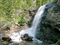 view gallery view galleryS29.5 km | Bridal Veil Falls in Scenic Hikes A beautiful walk through Colorado's colorful Rocky Mountain National Park. This 3 mile hike will take you through Aspen, Ponderosa Pine, and ending with a 20 foot waterfall of crystal clear mountain water. posted by: Team Laxson location: Colorado date approved: 05/28/2010 last visited: 05/31/2010 |
 view gallery view galleryS29.8 km | Mt. Chiquita in Mountain Summits A long, steep trail leads you to the 13069' summit. Loose rocks are abundant at the top. posted by: Flying Cacher location: Colorado date approved: 07/18/2006 last visited: 06/18/2010 |
 view gallery view gallerySE29.9 km | Storm Mountain Cadastral Survery disk in U.S. Benchmarks Cadastral Survey Disk near Storm Mountain Summit posted by: KingJR location: Colorado date approved: 11/26/2005 last visited: never |
 view gallery view gallerySE30.1 km | Storm Mountain Trail in Offroad Trails Storm Mountain trail area posted by: KingJR location: Colorado date approved: 01/17/2006 last visited: never |
 view gallery view galleryS31.2 km | Mt. Chapin in Mountain Summits Sheer drop offs, plush green mountain tundra and large rocks best describe this summit. posted by: Flying Cacher location: Colorado date approved: 07/18/2006 last visited: 06/18/2010 |
|