 view gallery view gallery E1.6 km E1.6 km
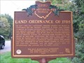
|   Land Ordinance of 1785 : The Seven Ranges Marker Land Ordinance of 1785 : The Seven Ranges Marker
in Ohio Historical Markers Ohio State Historical Marker located on Ohio 39 on the state line, Columbiana County, Ohio, commemorating the Land Ordinance of 1785 and the Seven Ranges. posted by:  Red Shoe & The Navigator Red Shoe & The Navigator location: Ohio date approved: 09/17/2006 last visited: 04/19/2019 |
 view gallery view galleryE1.6 km |  Tripoint of Ohio/Pennsylvania/West Virginia Tripoint - United States Tripoint of Ohio/Pennsylvania/West Virginia Tripoint - United States
in Tripoints and Multipoints This state-level tripoint lies in the Ohio River near an historic surveying location. posted by:  Ernmark Ernmark location: Pennsylvania date approved: 06/27/2014 last visited: 04/19/2019 |
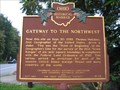 view gallery view galleryE1.6 km | Gateway To The Northwest in Ohio Historical Markers Ohio State Historical Marker located on Ohio 39 on the state line, Columbiana County, Ohio, commemorating Thomas Hutchins and the location of the “point of beginning” for the survey that became the “Gateway to the Northwest.” posted by: Red Shoe & The Navigator location: Ohio date approved: 09/18/2006 last visited: 04/19/2019 |
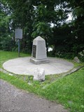
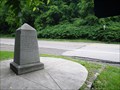
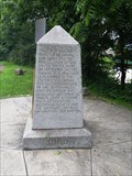 view gallery view galleryE1.6 km |  Beginning Point of the U.S. Public Land Survey - East Liverpool, OH/Beaver Co., PA Beginning Point of the U.S. Public Land Survey - East Liverpool, OH/Beaver Co., PA
in Public Land Survey Marks A 'Witness Monument' placed at the Ohio/Pennsylvania border commemorating the spot 1112 feet South which served as the starting point of the 'western lands' eventually stretching to the West Coast. posted by: Ernmark location: Ohio date approved: 11/10/2014 last visited: 04/19/2019 |
 view gallery view galleryE1.6 km |  Ohio / Pennsylvania Crossing - Harvey Ave (OH Rt.39) / Midland Rd. (PA Rt. 68) Ohio / Pennsylvania Crossing - Harvey Ave (OH Rt.39) / Midland Rd. (PA Rt. 68)
in Border Crossings Highway crossing between Ohio & Pennsylvania just north of the Ohio River, and near an important spot in surveying history. posted by: Ernmark location: Pennsylvania date approved: 06/27/2014 last visited: 04/19/2019 |
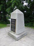 view gallery view galleryE1.6 km |  Beginning Point of the U.S. Public Land Survey - East Liverpool, OH/Beaver Co., PA Beginning Point of the U.S. Public Land Survey - East Liverpool, OH/Beaver Co., PA
in U.S. National Register of Historic Places Monument placed at the Ohio/Pennsylvania border commemorating the spot 1112 feet South which served as the starting point of the 'western lands' eventually stretching to the West Coast. posted by: Ernmark location: Ohio date approved: 08/14/2014 last visited: 04/19/2019 |
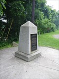 view gallery view galleryE1.6 km |  Beginning Point of the U.S. Public Land Survey - East Liverpool, OH/Beaver Co., PA Beginning Point of the U.S. Public Land Survey - East Liverpool, OH/Beaver Co., PA
in U.S. Historic Survey Stones and Monuments Monument placed at the Ohio/Pennsylvania border commemorating the spot 1112 feet South which served as the starting point of the 'western lands' eventually stretching to the West Coast. posted by: Ernmark location: Pennsylvania date approved: 08/13/2014 last visited: 04/19/2019 |
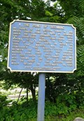 view gallery view galleryE1.6 km |  The Point of Beginning - Beaver County, PA The Point of Beginning - Beaver County, PA
in Signs of History Historical marker noting the location of the Point of Beginning for the surveying of the Western Lands of the United States. posted by: Ernmark location: Pennsylvania date approved: 06/30/2014 last visited: 04/19/2019 |
 view gallery view gallery NE1.8 km NE1.8 km
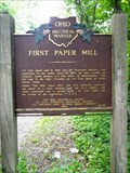
| First Paper Mill / Little Beaver Creek Bridge (#4-15) - Calcutta, OH in Ohio Historical Markers Marker placed in 1965 just west of the OH/PA border commemorating the first paper mill established in Ohio & the Northwest Territory, and the earliest known covered bridge in Ohio. posted by: Ernmark location: Ohio date approved: 07/10/2014 last visited: 05/04/2019 |
 view gallery view galleryNE1.9 km | Ohio/Pennsylvania Crossing - Calcutta RD/OH 430 in Border Crossings Rural road crossing between Ohio & Pennsylvania. posted by: Ernmark location: Ohio date approved: 06/27/2014 last visited: 12/15/2020 |
 view gallery view gallery SE2.3 km SE2.3 km
|  Little Blue Run Dam, Pennsylvania Little Blue Run Dam, Pennsylvania
in Water Dams holding a reservoir used as depository of coal ash and with a dark blue color because of its high content of selenium posted by: sherpes location: Pennsylvania date approved: 07/21/2009 last visited: never |
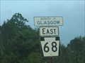 view gallery view galleryE2.3 km |  Glasgow, Pennsylvania Glasgow, Pennsylvania
in Small Town, Big Name Borough in Beaver County, Pennsylvania. posted by: Red Shoe & The Navigator location: Pennsylvania date approved: 09/10/2006 last visited: 06/21/2014 |
 view gallery view gallery W2.9 km W2.9 km
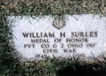
|  William H. Surles-East Liverpool, OH William H. Surles-East Liverpool, OH
in Medal Of Honor Resting Places Civil War Medal of Honor Recipient for action at Perryville, KY on October 8, 1862. He is buried in Riverview Cemetery, East Liverpool, OH in Section 2, Lot 47. posted by: Don.Morfe location: Ohio date approved: 05/25/2019 last visited: 12/05/2021 |
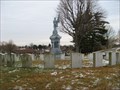 view gallery view galleryW2.9 km |  The Civil War Soldier ~ Riverview Cemetery ~ East Liverpool Ohio The Civil War Soldier ~ Riverview Cemetery ~ East Liverpool Ohio
in American Civil War Monuments and Memorials The Civil War Soldier Statue diligently stands watch over this hallowed ground posted by: BigPapaMark location: Ohio date approved: 01/04/2009 last visited: 05/12/2009 |
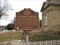 view gallery view galleryW3.1 km | Riverview Cemetery ~ 12-15 in Ohio Historical Markers Ohio Historical Marker in Riverview Cemetery is a must see for anyone interested in Ohio Historical places. posted by: BigPapaMark location: Ohio date approved: 01/04/2009 last visited: 07/24/2010 |
 view gallery view gallery SW3.1 km SW3.1 km
| Ohio/West Virginia Crossing along US 30 - East Liverpool/Chester in Border Crossings One of two Ohio River crossings in this area between Ohio & West Virginia. posted by: Ernmark location: Ohio date approved: 06/27/2014 last visited: 04/15/2024 |
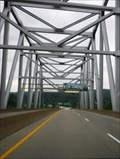
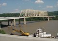 view gallery view gallerySW3.1 km |  LONGEST - Simple Truss Bridge in North America - Chester, WV LONGEST - Simple Truss Bridge in North America - Chester, WV
in Superlatives The Jennings Randolph Bridge, built in 1977, is the largest simple truss bridge in North America, spanning 745 feet between Chester, West Virginia and East Liverpool, Ohio. posted by: silverquill location: West Virginia date approved: 01/28/2009 last visited: 04/06/2024 |
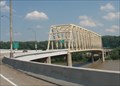 view gallery view gallerySW3.1 km |  Jennings Randolph Bridge - Chester WV Jennings Randolph Bridge - Chester WV
in People-Named Places Named for Senator Jennings Randolph, this bridge, built in 1977, is the largest simple truss bridge in North America, spanning 745 feet from Chester, WV, to East Liverpool, OH. posted by: silverquill location: West Virginia date approved: 01/28/2009 last visited: 04/06/2024 |
 view gallery view gallerySW3.1 km |  Jennings Randolph Bridge - Chester WV Jennings Randolph Bridge - Chester WV
in Truss Bridges The Jennings Randolph Bridge, built in 1977, is the largest simple truss bridge in North America, spanning 745 feet between Chester, West Virginia and East Liverpool, Ohio. posted by: silverquill location: West Virginia date approved: 01/28/2009 last visited: 04/06/2024 |
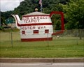 view gallery view gallerySW3.1 km |  The World's Largest Tea Pot The World's Largest Tea Pot
in Odd-Shaped Buildings The Worlds' Largest Tea Pot, Located in Checster, WV posted by: Medic005 location: West Virginia date approved: 08/18/2005 last visited: 04/19/2019 |
 view gallery view gallerySW3.2 km |  World's Largest Teapot World's Largest Teapot
in Ginormous Everyday Objects Retired roadside concession stand continues to make drivers rubberneck!
It's on the onramp from eastbound Rt2 in Chester, WV to the bridge leading north into Ohio. I don't know what was served from this former concession stand...maybe tea? After viewing this red and white wonder, I promptly turned around to head back to the truck and sprained my ankle in a ginormous hole nearby! Watch out! posted by: Algoma! location: West Virginia date approved: 09/25/2007 last visited: 04/19/2019 |
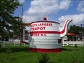 view gallery view gallerySW3.2 km |  World's Largest Teapot World's Largest Teapot
in Roadside Attractions A former concession and souvenier stand, this teapot was constructed in 1938.
It's on the onramp from eastbound Rt2 in Chester, WV to the bridge leading north into Ohio. posted by: Algoma! location: West Virginia date approved: 09/25/2007 last visited: 04/19/2019 |
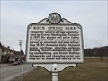 view gallery view gallerySW3.4 km |  Rock Spring Park Rock Spring Park
in West Virginia Historical Markers Named for natural spring used by George Washington. posted by: dukemartin location: West Virginia date approved: 02/15/2018 last visited: 07/07/2022 |
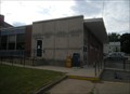 view gallery view gallerySW3.5 km |  Chester, West Virginia 26034 Chester, West Virginia 26034
in U.S. Post Offices On the tip of the northern panhandle, between Ohio and Pennsylvania posted by: sherpes location: West Virginia date approved: 07/28/2009 last visited: 07/20/2005 |
 view gallery view gallerySW3.7 km |  McDonald's #12197 - Chester, West Virginia McDonald's #12197 - Chester, West Virginia
in Wi-Fi Hotspots Free Wi-Fi is served daily at this McDonald's, located at 431 Carolina Avenue (State Route 2) in the Town of Chester, Hancock County, West Virginia posted by: outdoorboy34 location: West Virginia date approved: 12/16/2012 last visited: 12/18/2020 |
|