 view gallery view gallery E17.2 km E17.2 km
|   First Indian Agency - 151 First Indian Agency - 151
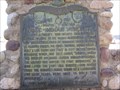
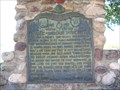
in D.U.P. Historic Markers The first Indian Agency located in Tabiona Utah on Hwy 35 posted by:  Mom the Cook & cashnhubby Mom the Cook & cashnhubby location: Utah date approved: 06/05/2011 last visited: 06/02/2011 |
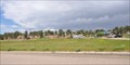
 view gallery view gallery S17.4 km S17.4 km
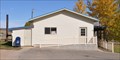
|  Fruitland, Utah 84027 Fruitland, Utah 84027
in U.S. Post Offices This Post Office is located at 6186 S 45000 West in Fruitland, Utah. posted by: brwhiz location: Utah date approved: 11/09/2011 last visited: never |
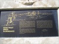
 view gallery view galleryE17.5 km |  First Indian Agency First Indian Agency
in Utah Historical Markers Utah's first Indian Agency located in Tabiona. posted by:  stevedc323 stevedc323 location: Utah date approved: 11/02/2009 last visited: 10/13/2015 |
 view gallery view gallery NW18 km NW18 km
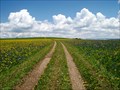
|  Wolf Creek Area Wild Flowers - Utah USA Wolf Creek Area Wild Flowers - Utah USA
in Flower Fields Huge blanket of wild flowers near Wolf Creek campground in Utah. posted by: The_Simpsons location: Utah date approved: 06/11/2011 last visited: 09/26/2011 |
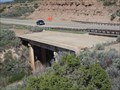 view gallery view gallery SE20.6 km SE20.6 km
|  US Highway 40 Old Bridge - Fruitland, Utah US Highway 40 Old Bridge - Fruitland, Utah
in Orphaned Bridges An abandoned bridge along US Highway 40 east of Fruitland Utah. posted by: Mom the Cook & cashnhubby location: Utah date approved: 06/02/2011 last visited: 10/16/2011 |
 view gallery view gallerySE23.8 km |  Pinion Ridge Rest Area Pinion Ridge Rest Area
in Highway Rest Areas This Highway Rest Area is located on the north side of US Highway 40 just east of the junction with Utah Highway 208, about 7 miles east of Fruitland, Utah. posted by: brwhiz location: Utah date approved: 05/15/2013 last visited: never |
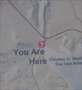
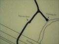 view gallery view gallery SW26.6 km SW26.6 km
|  YOU ARE HERE at Strawberry River Discovery Trail - Utah YOU ARE HERE at Strawberry River Discovery Trail - Utah
in 'You Are Here' Maps The Strawberry River Discovery Trail is located at the Strawberry Marina turnoff on US Highway 40, Wasatch County Utah. posted by: Mom the Cook & cashnhubby location: Utah date approved: 06/07/2011 last visited: 11/13/2022 |
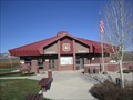 view gallery view gallerySW26.6 km |  Strawberry Visitors Information Center - Wasatch County, Utah Strawberry Visitors Information Center - Wasatch County, Utah
in Tourist Information Centers - Visitor Centers The Strawberry Visitors Information Center is in Wasatch County Utah posted by: Mom the Cook & cashnhubby location: Utah date approved: 06/05/2011 last visited: 11/13/2022 |
 view gallery view gallerySW26.6 km | Dominguez Escalante Expedition 1776-1976 - Wasatch County Utah in Utah Historical Markers The Dominguez Escalante Expedition marker is located near US Highway 40 east of Heber City Utah. posted by: Mom the Cook & cashnhubby location: Utah date approved: 06/07/2011 last visited: 11/13/2022 |
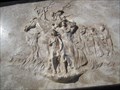 view gallery view gallerySW26.6 km |  Dominguez Escalante Expedition & Utah History Monument - Wasatch County, Utah Dominguez Escalante Expedition & Utah History Monument - Wasatch County, Utah
in Relief Art Sculptures This history monument is located in the Strawberry Valley, Uinta National Forest, east of Heber City Utah. posted by: Mom the Cook & cashnhubby location: Utah date approved: 06/07/2011 last visited: 11/13/2022 |
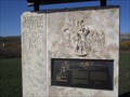 view gallery view gallerySW26.6 km |  Dominguez Escalante Expedition 1776-1976 - Wasatch County Utah Dominguez Escalante Expedition 1776-1976 - Wasatch County Utah
in Spirit of '76 The Dominguez Escalante Expedition Spirit of 1976 Monument is located near US Highway 40 east of Heber City Utah. posted by: Mom the Cook & cashnhubby location: Utah date approved: 06/06/2011 last visited: 11/13/2022 |
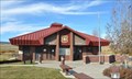 view gallery view gallerySW26.6 km |  Strawberry Visitor Center Strawberry Visitor Center
in Ranger Stations This Ranger Station is located on the south side of US Highway 40 approximately 23 miles southwest of Heber City, Utah. posted by: brwhiz location: Utah date approved: 05/20/2013 last visited: 11/13/2022 |
 view gallery view gallerySW26.6 km | Strawberry Visitor Center in 'You Are Here' Maps You Are Here at the US Forest Service Strawberry Recreation Area Ranger Station and Visitor Center. posted by: brwhiz location: Utah date approved: 04/08/2012 last visited: 11/13/2022 |
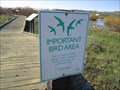 view gallery view gallerySW26.6 km |  Strawberry River Discovery Trail - Wasatch County, Utah Strawberry River Discovery Trail - Wasatch County, Utah
in Birdwatching Locations The Strawberry River Discovery Trail is located Wasatch County Utah. posted by: Mom the Cook & cashnhubby location: Utah date approved: 06/07/2011 last visited: 11/13/2022 |
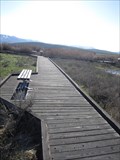 view gallery view gallerySW26.6 km |  Strawberry River Discovery Trail Boardwalk - Wasatch County, Utah Strawberry River Discovery Trail Boardwalk - Wasatch County, Utah
in Non-Coastal Boardwalks The Strawberry River Discovery Trail Boardwalk is located at the Strawberry Marina turnoff on US Highway 40, Wasatch County Utah. posted by: Mom the Cook & cashnhubby location: Utah date approved: 06/05/2011 last visited: 11/13/2022 |
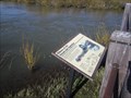 view gallery view gallerySW26.6 km |  Ribbons of Life, along the Strawberry River - Wasatch County, Utah Ribbons of Life, along the Strawberry River - Wasatch County, Utah
in Flora and Fauna Information Signs The Strawberry River Discovery Trail is located at the Strawberry Marina turnoff on US Highway 40, Wasatch County Utah. posted by: Mom the Cook & cashnhubby location: Utah date approved: 06/05/2011 last visited: 11/13/2022 |
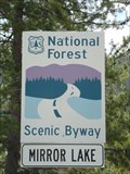 view gallery view galleryNW27.4 km |  Mirror Lake Scenic Byway - Kamas, Utah Mirror Lake Scenic Byway - Kamas, Utah
in National Scenic Byways Mirror Lake Scenic Byway posted by: Mooroid location: Utah date approved: 06/17/2011 last visited: 08/24/2011 |
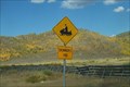 view gallery view gallery W27.8 km W27.8 km
|  Snowmobile Crossing--US Highway 40 near Strawberry Snowmobile Crossing--US Highway 40 near Strawberry
in Uncommon Crossing Signs This is a great area to go snowmobiling in the winter. We went on a campout and took a photo of the snowmobile crossing sign along US Highway 40 Westbound, west of Strawberry Res, east of Heber City, Utah. posted by: PeanutsParents location: Utah date approved: 09/28/2008 last visited: 05/01/2011 |
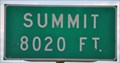 view gallery view galleryW29.6 km |  Summit ~ Elevation 8020 Feet Summit ~ Elevation 8020 Feet
in Elevation Signs This Elevation Sign is located on the west side of US Highway 40, just north of Canyon Road, about 16.5 miles southeast of Heber, Utah posted by: brwhiz location: Utah date approved: 02/09/2013 last visited: never |
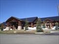 view gallery view galleryW29.8 km |  Daniels Summit Lodge - Daniels, Utah Daniels Summit Lodge - Daniels, Utah
in Lodge-Style Accommodations The Daniels Summit Lodge is located at the summit of Daniels Canyon along US highway 40, east of Heber Utah. posted by: Mom the Cook & cashnhubby location: Utah date approved: 06/08/2011 last visited: 07/08/2017 |
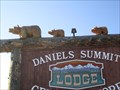 view gallery view galleryW29.8 km |  The Three Bears Daniel Summit - Utah The Three Bears Daniel Summit - Utah
in Outside Wooden Display Carvings Find the three bears on US Highway 40 at Daniel Summit in Wasatch County Utah. posted by: Mom the Cook & cashnhubby location: Utah date approved: 06/06/2011 last visited: 01/23/2016 |
 view gallery view galleryW29.8 km |  The Three Bears Daniel Summit - Utah The Three Bears Daniel Summit - Utah
in Bear Statues On US Highway 40 at Daniel Summit in Wasatch County Utah are the three bears. posted by: Mom the Cook & cashnhubby location: Utah date approved: 06/07/2011 last visited: 01/23/2016 |
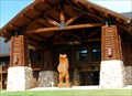 view gallery view galleryW29.9 km | Daniels Summit Lodge Bear in Outside Wooden Display Carvings Giant bear for your enjoyment posted by: snownomi location: Utah date approved: 07/30/2009 last visited: 07/08/2017 |
 view gallery view galleryNW30.3 km |  Provo River Overlook - Wasatch National Forest - Utah Provo River Overlook - Wasatch National Forest - Utah
in Scenic Overlooks Provo River Overlook - Wasatch National Forest - Utah. posted by: The_Simpsons location: Utah date approved: 06/17/2011 last visited: 05/11/2016 |
 view gallery view gallery N35.4 km N35.4 km
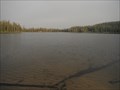
|  Uintas Cache #2: Pinto Lake Uintas Cache #2: Pinto Lake
in Natural Lakes This is Pinto Lake. posted by: lindon4her location: Utah date approved: 07/02/2012 last visited: never |
|