 view gallery view gallery E3.4 km E3.4 km
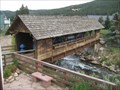
|   Covered Bridge in Nederland, CO Covered Bridge in Nederland, CO
in Covered Bridges This covered bridge is located in Nederland, CO.
posted by:  Team Min Dawg Team Min Dawg location: Colorado date approved: 10/14/2008 last visited: 09/21/2014 |
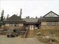
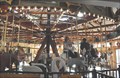 view gallery view galleryE3.4 km |  Carousel of Happiness Carousel of Happiness
in Roadside Attractions This Roadside Attraction is located at 20 Lakeview Drive in Nederland, Colorado. posted by:  brwhiz brwhiz location: Colorado date approved: 12/06/2012 last visited: 05/13/2018 |
 view gallery view galleryE3.4 km |  Carousel of Happiness Carousel of Happiness
in Carousels The Carousel of Happiness is located at 20 Lakeview Drive in Nederland, Colorado. posted by: brwhiz location: Colorado date approved: 12/13/2012 last visited: 05/13/2018 |
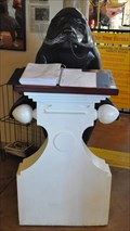 view gallery view galleryE3.4 km |  Carousel of Happiness Guest Book Carousel of Happiness Guest Book
in Guest Books This Guest Book for the Carousel of Happiness is located at 20 Lakeview Drive in Nederland, Colorado. posted by: brwhiz location: Colorado date approved: 12/06/2012 last visited: 05/13/2018 |
 view gallery view galleryE3.4 km |  The Carousel of Happiness Penny Smasher The Carousel of Happiness Penny Smasher
in Penny Smashers This four-design Penny Smasher is in The Carousel of Happiness building at 20 Lakeview Drive in Nederland, Colorado. posted by: brwhiz location: Colorado date approved: 10/22/2011 last visited: 09/21/2014 |
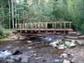 view gallery view gallery W5 km W5 km
|  Footbridge at Hesse Trailhead Footbridge at Hesse Trailhead
in Hiking Path Footbridges This footbridge can be found at the start of the Hesse trail, a beautiful hiking experience in the High Country. posted by: Team Laxson location: Colorado date approved: 09/01/2008 last visited: never |
 view gallery view gallery SE5.8 km SE5.8 km
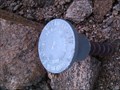
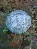
|  Gilpin County Line Gilpin County Line
in U.S. Benchmarks Gilpin County / Boulder County Line posted by: Akkhima location: Colorado date approved: 05/11/2009 last visited: never |
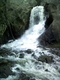
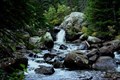 view gallery view galleryW6 km |  Boulder Creek Waterfall Boulder Creek Waterfall
in Waterfalls Cascading waterfall on the Devil's Thumb trail near Eldora. posted by: klperez location: Colorado date approved: 09/17/2006 last visited: 07/16/2007 |
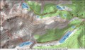
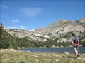 view gallery view galleryW9.7 km |  Jasper Lake Trail Jasper Lake Trail
in Scenic Hikes Jasper Lake is a kidney shaped lake surrounded by spruce forest. The lake contains cutthroat, brook, and brown trout.
The hike to Jasper lake is 10.5 miles round trip, with 1,800 ft. elevation gain. posted by: Team Laxson location: Colorado date approved: 09/01/2008 last visited: never |
 view gallery view gallery N10 km N10 km
|  Niwot Ridge Tundra Cam II Niwot Ridge Tundra Cam II
in Web Cameras --------------------------------
THIS CAM IS TEMPORARILY UNAVAILABLE. SEEMS THAT THE WINTER SNOW AND WIND MAY HAVE BEEN A BIT MUCH FOR IT.
-------------------------------------------------
The Institute of Arctic and Alpine Research posted by: zoltig location: Colorado date approved: 12/30/2005 last visited: 08/27/2007 |
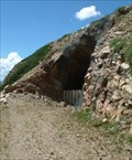 view gallery view galleryW10.1 km |  Eye of the Needle Tunnel Eye of the Needle Tunnel
in Abandoned Train Tunnels Eye of the Needle Tunnel, On the Denver Northwestern and Pacific RR. A route that was replaced by the operational Moffat Tunnel. Currently known as Moffatt Road. This tunnel has been open up until the early 00's. It is now blocked off posted by: 45radman location: Colorado date approved: 01/26/2007 last visited: never |
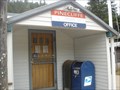 view gallery view gallerySE11.1 km |  Pinecliffe, Colorado 80471 Pinecliffe, Colorado 80471
in U.S. Post Offices Pinecliffe is an unincorporated, small mountain town and a U.S. Post Office located in Boulder County and Gilpin County, Colorado. posted by: DougK location: Colorado date approved: 10/15/2011 last visited: never |
 view gallery view galleryE12.7 km | Boulder Falls - Boulder, Colorado in Waterfalls A Beautiful Falls in Boulder Canyon posted by: Big B Bob location: Colorado date approved: 06/23/2008 last visited: 10/07/2018 |
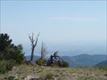 view gallery view gallery NE12.7 km NE12.7 km
|  Sugarloaf Mountain Sugarloaf Mountain
in Mountain Summits A short hike up to the top of Sugarloaf Mountain (8,912 feet), with spectacular views of the Indian Peaks Wilderness, Rocky Mountain National Park, James Peak Wilderness Area, and the plains. posted by: Team Laxson location: Colorado date approved: 07/23/2008 last visited: 06/20/2010 |
 view gallery view gallerySE13 km |  Gilpin County Public Library - Gilpin County, CO Gilpin County Public Library - Gilpin County, CO
in Libraries This library serves the county of Gilpin which includes Black Hawk, Central City and Rollinsville. posted by: Outspoken1 location: Colorado date approved: 03/10/2010 last visited: never |
 view gallery view gallery NW14.3 km NW14.3 km
| Pawnee Peak in Mountain Summits A 13er wannabe in a very popular and accessable area. posted by: t-xman location: Colorado date approved: 10/02/2005 last visited: never |
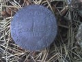
 view gallery view galleryE14.8 km | 1997 DOA Magnolia Drive Cadastral Benchmark in U.S. Benchmarks U.S. Department of Agriculture Cadastral Marker posted by: Nejmensi location: Colorado date approved: 11/08/2010 last visited: never |
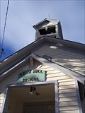
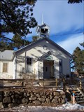 view gallery view galleryNE15.4 km |  OLDEST - Continuously Operating Public School in Colorado - Gold Hill, Colorado OLDEST - Continuously Operating Public School in Colorado - Gold Hill, Colorado
in Superlatives Gold Hill School serves a small community tied together by mountain topography, and has done so continuously since 1873. posted by: Big B Bob location: Colorado date approved: 11/24/2009 last visited: 07/29/2012 |
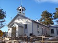
 view gallery view galleryNE15.4 km |  Gold Hill School - Gold Hill Historic District - Gold Hill, Colorado Gold Hill School - Gold Hill Historic District - Gold Hill, Colorado
in NRHP Historic Districts - Contributing Buildings Gold Hill School serves a small community tied together by mountain topography, and has done so continuously since 1873. posted by: Big B Bob location: Colorado date approved: 11/30/2009 last visited: 07/29/2012 |
 view gallery view galleryNE15.4 km |  Gold Hill School - Gold Hill, Colorado Gold Hill School - Gold Hill, Colorado
in One-Room Schoolhouses Gold Hill School serves a small community tied together by mountain topography, and has done so continuously since 1873. posted by: Big B Bob location: Colorado date approved: 11/23/2009 last visited: 07/29/2012 |
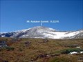 view gallery view galleryN15.6 km | Mt. Audubon Trail & Summit in Scenic Hikes Situated in the Indian Wilderness of Colorado's Front Range, Mount Audubon takes its place about one mile east of the Continental Divide and the resulting chain of rugged peaks that define the local geography. posted by: Team Laxson location: Colorado date approved: 09/14/2008 last visited: never |
 view gallery view galleryN15.6 km | Mt. Audubon Summit (13,223) in Mountain Summits Situated in the Indian Wilderness of Colorado's Front Range, Mount Audubon takes its place about one mile east of the Continental Divide and the resulting chain of rugged peaks that define the local geography. posted by: Team Laxson location: Colorado date approved: 09/18/2008 last visited: 10/19/2008 |
 view gallery view galleryNE15.6 km | General Store - Gold Hill Historic District - Gold Hill, Colorado in NRHP Historic Districts - Contributing Buildings In 1989, 47 buildings, including the Gold Hill General Store, were formed into the Gold Hill Historic District and placed on the National Register of Historic Places. posted by: Big B Bob location: Colorado date approved: 11/24/2009 last visited: 07/29/2012 |
 view gallery view galleryE15.8 km | GLO Miramonte Hwy 72 B in U.S. Benchmarks General Land Office Corner Marker posted by: pkacolorado location: Colorado date approved: 08/13/2007 last visited: 08/12/2007 |
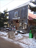
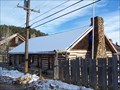 view gallery view galleryNE15.8 km |  Gold Hill Inn - Gold Hill, Colorado Gold Hill Inn - Gold Hill, Colorado
in Pubs and Inns n 1989, 47 buildings, including the Gold Hill Inn, were formed into the Gold Hill Historic District and placed on the National Register of Historic Places. posted by: Big B Bob location: Colorado date approved: 12/01/2009 last visited: 07/29/2012 |
|