
Jasper Lake Trail
Posted by:  Team Laxson
N 39° 58.484 W 105° 39.665
13S E 443549 N 4425162
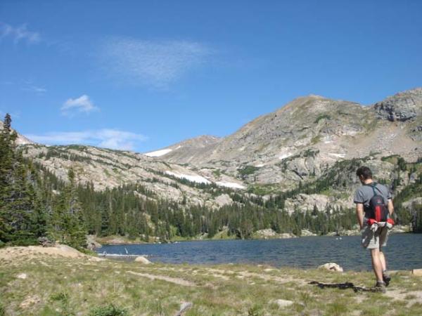
Jasper Lake is a kidney shaped lake surrounded by spruce forest. The lake contains cutthroat, brook, and brown trout.
The hike to Jasper lake is 10.5 miles round trip, with 1,800 ft. elevation gain.
Waymark Code: WM4JWW
Location: Colorado, United States
Date Posted: 09/01/2008
Views: 30
Jasper Lake delivers on the Indian Peaks' reputation as a premier wildflower, fishing and camping destination. Hikers will enjoy varied terrain and breathtaking scenery while following Jasper Creek and countless tributaries into a pristine subalpine wilderness. This popular destination is an ideal first-stop for multi-day trekkers heading west of or along the Continental Divide.
The trail begins on a steep dirt road lined with aspens and wildflowers, merging with the South Fork of Middle Boulder Creek at the Devils Thumb Bypass Trail junction (.85 miles : 9,455'). Bear right on the Devils Thumb Bypass Trail. Moderately steep switchbacks twist through dense forest, leveling off in a spacious meadow circled by aspens, braided with streams and dotted with summer wildflowers (1.25 miles : 9,625’). The trail officially crosses the Indian Peaks Wilderness Boundary (1.4 miles : 9,650') and re-enters the timber soon after (1.65 miles).
A moderate, rocky path alternates through forest, meadow and marsh to the Devils Thumb Trail - Woodland Lake Trail junction (2.2 miles, 9,792'). Veer right towards Jasper Lake. Rising quickly, the flower-studded trail is frequently awash in runoff or obscured by lingering snow through mid-July. Be patient with route finding, follow signposts and ignore social trails that ostensibly offer an easier passage; anticipate one sudden, poorly marked left turn over a tributary at 2.85 miles (10,215’).
The trail methodically climbs a south-facing valley wall to the Diamond Lake Trail junction (3.75 miles : 10,675’), beyond which it relaxes along moderate undulations in a thinning forest to the first of two spurs for Jasper Lake and backcountry campsite access (4.35 miles). *Note that Jasper Lake is not immediately visible from the main trail; this spur heads up a steep bank concealing its location. If disoriented, simply stay north in the valley and follow rising contours to the lake.
Jasper Lake (4.4 miles : 10,814’) is surrounded by flat, wooded terrain on three sides; a steep ridge rises sharply from its north shore making circumnavigation difficult. Well-defined social trails follow Jasper Lake’s south and west shorelines to secluded coves, protruding outcrops and marshy inlets. Respect the privacy of backcountry campsites while exploring the area. The main trail continues west of Jasper Lake to Devils Thumb Lake.
Key waypoints:
Parking: N39 57.100 W105 35.696
Trailhead: N39 57.280 W105 36.163
Meadow start: N39 57.364 W105 37.187
Meadow end: N39 57.536 W105 37.531
Jasper Lake Viewpoint: N39 58.485 W105 39.665