 view gallery view gallery NE28.6 km NE28.6 km
|   40 by 112 40 by 112
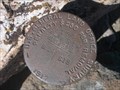
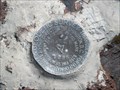
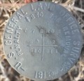
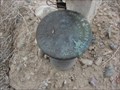
in U.S. Benchmarks A pipe cap in the desert posted by:  Will Jeep for Cache Will Jeep for Cache location: Utah date approved: 03/22/2007 last visited: 03/17/2007 |
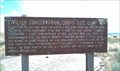 view gallery view galleryNE44.9 km |  Simpson Springs CCC Camp - Pony Express Trail, Utah Simpson Springs CCC Camp - Pony Express Trail, Utah
in Civilian Conservation Corps Located along the Pony Express Trail at Simpson Springs posted by: Lord Mot location: Utah date approved: 08/12/2013 last visited: never |
 view gallery view gallery W48.9 km W48.9 km
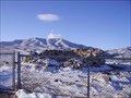
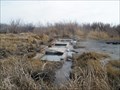
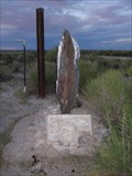
|  Canyon Station Canyon Station
in Pony Express Monuments Canyon Station Ruins located in Overland Canyon near Ibapah, Utah posted by: caverspencer location: Utah date approved: 02/16/2007 last visited: 11/30/2008 |
 view gallery view gallery SE49.6 km SE49.6 km
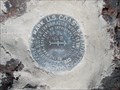
| KO0440 - "Crater" - RM2 - Delta, UT in U.S. Benchmarks This benchmark is a reference mark for the "Crater" benchmark, located on Fumarole Butte, situated northwest of Delta, Utah, in the south central area of the state. posted by: Chasing Blue Sky location: Utah date approved: 11/27/2012 last visited: 04/16/2011 |
 view gallery view gallerySE49.6 km | KO0440 - "Crater" - Delta, UT in U.S. Benchmarks This benchmark is located on Fumarole Butte, situated northwest of Delta, Utah, in the south central area of the state. posted by: Chasing Blue Sky location: Utah date approved: 04/20/2011 last visited: 04/16/2011 |
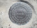 view gallery view gallerySE49.6 km | KO0440 - "Crater" RM1 - Delta, UT in U.S. Benchmarks This reference mark benchmark is located on Fumarole Butte, situated northwest of Delta, Utah, in the south central area of the state. posted by: Chasing Blue Sky location: Utah date approved: 11/27/2012 last visited: 04/16/2011 |
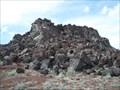 view gallery view gallerySE49.6 km |  Fumarole Butte - Delta, UT, USA Fumarole Butte - Delta, UT, USA
in Wikipedia Entries Fumerole Butte, situated northwest of Delta, is a extinct volcano in west-central Utah. posted by: Chasing Blue Sky location: Utah date approved: 11/27/2012 last visited: 04/16/2011 |
 view gallery view gallerySE49.6 km |  Fumarole Butte - Delta, UT Fumarole Butte - Delta, UT
in Mountain Summits Fumarole Butte, situated northwest of Delta, is an extinct volcano in west-central Utah. posted by: Chasing Blue Sky location: Utah date approved: 08/30/2011 last visited: 04/16/2011 |
 view gallery view gallerySE55 km |  Baker Hot Spring - Juab County, UT Baker Hot Spring - Juab County, UT
in Hot Springs Baker Hot Spring, lies about 20 miles northwest of Delta, Utah, but actually in Juab County. posted by: Chasing Blue Sky location: Utah date approved: 09/12/2011 last visited: 03/12/2011 |
 view gallery view gallery NW57.5 km NW57.5 km
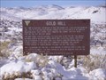
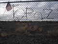
|  Gold Hill, Utah Gold Hill, Utah
in Ghost Towns Gold Hill posted by: caverspencer location: Utah date approved: 02/16/2007 last visited: never |
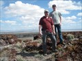
 view gallery view galleryNE61 km | USGLOS (Unknown PID) T7S R8W S3 S2 S10 S11 Section Corner in U.S. Benchmarks This General Land Office Survey marker is a Section Corner mark just outside the east entrance to the Dugway Proving Ground. posted by:  brwhiz brwhiz location: Utah date approved: 03/28/2012 last visited: never |
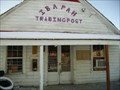 view gallery view galleryW63.4 km |  Ibapah Trading Post Ibapah Trading Post
in Payphones Working Payphone located at the Ibapah Trading post in Ibapah Utah. There is no cell service here so this is the only link to the outside world. posted by: caverspencer location: Utah date approved: 02/25/2007 last visited: never |
 view gallery view galleryNE64.9 km |  Aunt Libby's Pet Cemetery - Lookout Pass, UT Aunt Libby's Pet Cemetery - Lookout Pass, UT
in Pet Cemeteries Pet cemetary at Lookout Pass. The cemetary was originally constructed around 1850 for Libby Rockwell so she would have a place to burry her dogs that passed on. posted by: caverspencer location: Utah date approved: 02/16/2007 last visited: 05/29/2020 |
 view gallery view galleryNE65.7 km |  Lookout Pass ~ Elevation 6192 feet Lookout Pass ~ Elevation 6192 feet
in Elevation Signs Lookout Pass is on the old Pony Exprfess Trail southwest of Salt Lake City. posted by: brwhiz location: Utah date approved: 03/28/2012 last visited: 09/01/2013 |
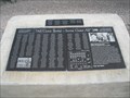
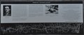
 view gallery view gallerySE66.3 km |  Topaz War Relocation Center - Delta, Ut Topaz War Relocation Center - Delta, Ut
in WWII Prisoner of War Camps The Topaz War Relocation Center, also known as the Central Utah Relocation Center (Topaz), was a camp which housed Nikkei -- Americans of Japanese descent and immigrants who had come to the United States from Japan. posted by: Team Min Dawg location: Utah date approved: 05/13/2010 last visited: 03/30/2018 |
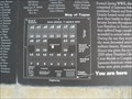 view gallery view gallerySE66.3 km |  Topaz War Relocation Center "You Are Here" - Delta, UT Topaz War Relocation Center "You Are Here" - Delta, UT
in 'You Are Here' Maps This "You Are Here" is on a marker for the Topaz War Relocation Center, northwest of Delta, Utah at 10000 West 4500 North. posted by: Chasing Blue Sky location: Utah date approved: 05/21/2011 last visited: 03/30/2018 |
 view gallery view gallerySE66.3 km |  Topaz War Relocation Center - Delta, UT Topaz War Relocation Center - Delta, UT
in World War II Sites The Topaz War Relocation Center was a forced relocation camp, housing Japanese Americans during World War II. posted by: Chasing Blue Sky location: Utah date approved: 08/01/2011 last visited: 03/30/2018 |
![Image for Topaz Internment Camp Post Office [Historic]](https://img.geocaching.com/waymarking/small/ec3cc8d9-a0a0-408d-8853-aa1ff6a98a13.JPG) view gallery view gallerySE66.6 km |  Topaz Internment Camp Post Office [Historic] Topaz Internment Camp Post Office [Historic]
in U.S. Post Offices This post office was located in the World War II Central Utah Internment Camp (Topaz) northwest of Delta. posted by: brwhiz location: Utah date approved: 09/09/2013 last visited: 03/30/2018 |
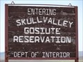 view gallery view galleryNE74.8 km |  Goshute Skull Valley Indian Reservation - Tooele County, Utah Goshute Skull Valley Indian Reservation - Tooele County, Utah
in Nations Within Nations Located approximately 45 miles southwest of Salt Lake City, Utah posted by: Lord Mot location: Utah date approved: 06/11/2011 last visited: never |
 view gallery view gallery E75.3 km E75.3 km
| Vernon, Utah 84080 in U.S. Post Offices This Post Office is located at 20 N Main Street in Vernon, Utah. posted by: brwhiz location: Utah date approved: 01/16/2012 last visited: 04/07/2012 |
 view gallery view gallerySE76.9 km | Utah State Road Right-of-Way Marker ~ US Highway 50 & 6 in U.S. Benchmarks This appears to be an older style of ROW Marker that contains no identifying designation or other information. posted by: brwhiz location: Utah date approved: 03/28/2012 last visited: never |
 view gallery view galleryNE78.4 km | Fisher Pass ~ Elevation 6496 feet in Elevation Signs Fisher Pass is the high point through the Stansbury Mountains along the route of the Lincoln Highway west of Salt Lake City. posted by: brwhiz location: Utah date approved: 03/29/2012 last visited: 12/02/2017 |
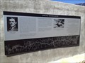 view gallery view galleryNE78.4 km |  Fisher Pass (aka Johnson Pass) Fisher Pass (aka Johnson Pass)
in Utah Historical Markers This marker describes the history of this pass named for Carl G. Fisher in 1919 and his efforts to create the Lincoln Highway. Interestingly, maps and local knowledge name this Johnson Pass. posted by: stevedc323 location: Utah date approved: 10/08/2014 last visited: 12/02/2017 |
 view gallery view gallerySE78.7 km | Gunnison Massacre Site in Utah Historical Markers There are two markers for the same massacre at this site. The Great Basin Museum in Delta removed the plaque on one marker because of vandalism. Apparently there are three sides to the story of this massacre. posted by: Team Min Dawg location: Utah date approved: 07/27/2009 last visited: never |
 view gallery view gallery SW78.9 km SW78.9 km
| U. S. Cadastral Survey Marker - Gandy, Utah in U.S. Benchmarks Another Benchmark at a fence corner in Gandy, Utah. posted by: JacobBarlow location: Utah date approved: 09/18/2007 last visited: 09/19/2007 |
|