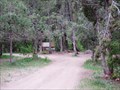
 view gallery view gallery N6.9 km N6.9 km
|   Free Camping in Lake Fork Canyon Free Camping in Lake Fork Canyon
in Free Campsites Free Camping in Lake Fork Canyon, Utah. posted by:  The_Simpsons The_Simpsons location: Utah date approved: 05/19/2012 last visited: 05/19/2012 |
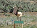 view gallery view gallery W10.6 km W10.6 km
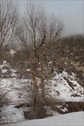
|  Elk on '89 Elk on '89
in Themed Homemade Mailboxes A really cool Elk Mailbox. posted by: JacobBarlow location: Utah date approved: 06/13/2007 last visited: 05/20/2014 |
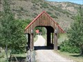 view gallery view galleryW10.6 km |  Highway '89 Covered Bridge Highway '89 Covered Bridge
in Covered Bridges I travel all over Utah all the time and this is the only covered bridge I've seen in the last year. The bridge is on someone's drive-way. posted by: JacobBarlow location: Utah date approved: 06/16/2007 last visited: 05/20/2014 |
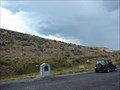 view gallery view gallery SW10.8 km SW10.8 km
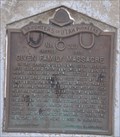
|  Given Family Massacre Given Family Massacre
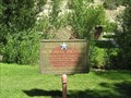
in Utah Historical Markers In the spring of 1865 John Given and his wife Eliza and their four children, John Jr., Mary, Anna, and Martha settled in the meadowland about 110 feet west of here. They built a cabin and willow shanty... posted by: JacobBarlow location: Utah date approved: 08/28/2007 last visited: 08/09/2015 |
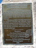
 view gallery view gallerySW10.8 km |  Given Family Massacre, Utah County, Utah ~ USA Given Family Massacre, Utah County, Utah ~ USA
in Human Migration Monuments The Given family were migrants that settled outside of a fortified established settlement. They became early victims of the Black Hawk War, which took the lives of about 75 pioneer settlers in central Utah. posted by: brwhiz location: Utah date approved: 11/19/2012 last visited: 08/09/2015 |
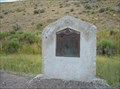 view gallery view gallerySW10.8 km |  Given Family Massacre - 227 Given Family Massacre - 227
in D.U.P. Historic Markers In the spring of 1865 John Given and his wife Eliza and their four children, John Jr., Mary, Anna, and Martha settled in the meadowland about 110 feet west of here. posted by:  Mooroid Mooroid location: Utah date approved: 08/01/2011 last visited: 09/07/2016 |
 view gallery view gallery NE13.2 km NE13.2 km
|  Mill Fork Cemetery - Mill Fork, UT Mill Fork Cemetery - Mill Fork, UT
in Worldwide Cemeteries Mill Fork Cemetery is an old, inactive cemetery of about thirty seven burials, located off of US 6 in the rural community of Mill Fork, UT. posted by: QuarrellaDeVil location: Utah date approved: 10/30/2016 last visited: 06/30/2018 |
 view gallery view gallery NW13.2 km NW13.2 km
| Birdseye Marble Quarry Heartbeat of the Canyon in Utah Historical Markers Originally operated by the Mormon Church and other from the 1880's to the 1940's. posted by: JacobBarlow location: Utah date approved: 09/11/2007 last visited: 09/06/2021 |
 view gallery view galleryNW14.5 km |  Highway 89 Shoe Tree Highway 89 Shoe Tree
in Shoe Trees A tree just off of the road, with many shoes in it. It is in a sort of out of the way place. But there are a lot of shoes there. posted by: Toja7 location: Utah date approved: 03/08/2011 last visited: 05/20/2014 |
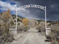
 view gallery view galleryNW14.8 km | U Pace O Ranch, Thistle, Utah in Utah Historical Markers This land has been farmed since about 1850 and was utilized by native Americans prior to that. posted by: Queens Blessing location: Utah date approved: 10/29/2010 last visited: 05/27/2020 |
 view gallery view galleryNW15.4 km |  Thistle Ghost Town Thistle Ghost Town
in Ghost Towns Was the town of Thistle Utah posted by: firennice location: Utah date approved: 07/03/2008 last visited: 04/02/2017 |
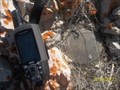 view gallery view galleryNW15.9 km |  Thistle Junction Thistle Junction
in U.S. Benchmarks Benchmark on the top of the ridge. posted by: BMars7391 location: Utah date approved: 03/25/2012 last visited: 03/22/2012 |
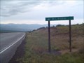
 view gallery view galleryNE18.2 km | Williams and Powell Ranch in Utah Historical Markers Historical marker located at the Tie Fork rest area off US Hwy 6. posted by:  BruceS BruceS location: Utah date approved: 07/05/2011 last visited: 06/30/2018 |
 view gallery view gallery E18.8 km E18.8 km
|  Highway 6 Rest Area - Tucker, UT Highway 6 Rest Area - Tucker, UT
in Blue Star Memorial Highway Markers A rest area on U.S. Highway 6 posted by: DrJay location: Utah date approved: 08/15/2007 last visited: 06/30/2018 |
 view gallery view gallery S19.2 km S19.2 km
|  Milburn, Utah Milburn, Utah
in Wikipedia Entries Milburn is a town in Sanpete County, Utah, United States. The population was 1,160 at the 2000 census. posted by: JacobBarlow location: Utah date approved: 12/02/2007 last visited: 06/11/2012 |
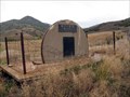
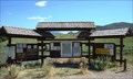 view gallery view galleryNW19.3 km |  Diamond 411 - Traveler Information Kiosk - Utah USA Diamond 411 - Traveler Information Kiosk - Utah USA
in Tourist Information Centers - Visitor Centers Diamond 411 - Traveler Information Kiosk - Diamond Fork Canyon access, Utah posted by: The_Simpsons location: Utah date approved: 08/01/2011 last visited: 04/14/2016 |
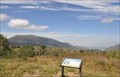
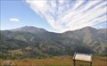
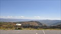 view gallery view galleryW21.1 km |  Nebo Loop Scenic Byway ~ Beaver Dam Overlook Nebo Loop Scenic Byway ~ Beaver Dam Overlook
in National Scenic Byways This is one of numerous spots along the length of the Byway where you can get off the highway, stretch your legs, and partake of the fresh air while viewing great expanses of the breath-taking scenery in greater detail. posted by: brwhiz location: Utah date approved: 12/03/2013 last visited: never |
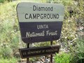 view gallery view galleryN22.2 km | Diamond Campground - Uinta National Forest - Utah USA in Campgrounds Diamond Campground - Uinta National Forest - Utah USA - The_Simpsons favorite place to camp. posted by: The_Simpsons location: Utah date approved: 07/26/2011 last visited: 04/14/2016 |
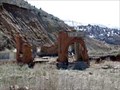
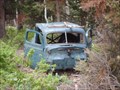 view gallery view galleryS22.2 km |  A Dead Car in the Mountains A Dead Car in the Mountains
in Abandoned Dead Vehicles I found this dead Vehicle in Mountains posted by: robbdogg120 location: Utah date approved: 06/10/2007 last visited: never |
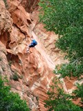 view gallery view galleryN23 km |  Rock Climbing at Red Ledges - Utah Rock Climbing at Red Ledges - Utah
in Established Rock Climbing Areas Rappelling at Red Ledges picnic area in Diamond Fork Canyon. posted by: The_Simpsons location: Utah date approved: 03/17/2012 last visited: 04/14/2016 |
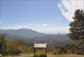
 view gallery view galleryW23.3 km | Nebo Loop Scenic Byway ~ Utah Lake Overlook in National Scenic Byways This is one of numerous spots along the length of the Byway where you can get off the highway, stretch your legs, and partake of the fresh air while viewing great expanses of the breath-taking scenery in greater detail. posted by: brwhiz location: Utah date approved: 12/03/2013 last visited: never |
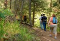 view gallery view galleryN23.8 km |  Fifth Water Hot Pots Fifth Water Hot Pots
in Scenic Hikes A 2.75 mile (one way) hike to some hot springs pools and a waterfall. posted by: JacobBarlow location: Utah date approved: 08/11/2010 last visited: 03/23/2011 |
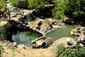 view gallery view galleryN24.5 km |  Fifth Water Hot Pots Fifth Water Hot Pots
in Hot Springs A relatively level 2.75 mile hike will get you to these hot spring pools and waterfall. posted by: JacobBarlow location: Utah date approved: 08/11/2010 last visited: 03/23/2011 |
 view gallery view galleryW24.6 km | Nebo Loop Scenic Byway ~ Bald Mountain Overlook in National Scenic Byways This is one of numerous spots along the length of the Byway where you can get off the highway, stretch your legs, and partake of the fresh air while viewing great expanses of the breath-taking scenery in greater detail. posted by: brwhiz location: Utah date approved: 12/03/2013 last visited: never |
 view gallery view galleryW25.1 km | Nebo Loop Scenic Byway ~ Salt Creek Overlook in National Scenic Byways This is one of numerous spots along the length of the Byway where you can get off the highway, stretch your legs, and partake of the fresh air while viewing the Byway's namesake at a fairly close distance. posted by: brwhiz location: Utah date approved: 12/03/2013 last visited: never |
|