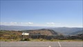
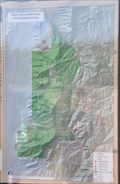
 view gallery view gallery N6 km N6 km
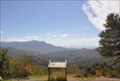
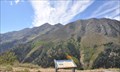
|   Nebo Loop Scenic Byway ~ Beaver Dam Overlook Nebo Loop Scenic Byway ~ Beaver Dam Overlook
in National Scenic Byways This is one of numerous spots along the length of the Byway where you can get off the highway, stretch your legs, and partake of the fresh air while viewing great expanses of the breath-taking scenery in greater detail. posted by:  brwhiz brwhiz location: Utah date approved: 12/03/2013 last visited: never |
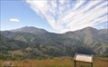 view gallery view gallery NW6.4 km NW6.4 km
| Nebo Loop Scenic Byway ~ Bald Mountain Overlook in National Scenic Byways This is one of numerous spots along the length of the Byway where you can get off the highway, stretch your legs, and partake of the fresh air while viewing great expanses of the breath-taking scenery in greater detail. posted by: brwhiz location: Utah date approved: 12/03/2013 last visited: never |
 view gallery view galleryNW6.6 km | Nebo Loop Scenic Byway ~ Utah Lake Overlook in National Scenic Byways This is one of numerous spots along the length of the Byway where you can get off the highway, stretch your legs, and partake of the fresh air while viewing great expanses of the breath-taking scenery in greater detail. posted by: brwhiz location: Utah date approved: 12/03/2013 last visited: never |
 view gallery view galleryNW7.6 km | Nebo Loop Scenic Byway ~ Santaquin Overlook in National Scenic Byways This is one of numerous spots along the length of the Byway where you can get off the highway, stretch your legs, and partake of the fresh air while viewing great expanses of the breath-taking scenery in greater detail. posted by: brwhiz location: Utah date approved: 12/03/2013 last visited: never |
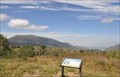
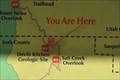 view gallery view gallery SW7.7 km SW7.7 km
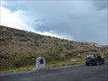
|  Devil's Kitchen Geologic Site Devil's Kitchen Geologic Site
in 'You Are Here' Maps You Are Here on the Nebo Loop Scenic Byway at the entrance to the short trail that leads to the Devil's Kitchen Overlook. posted by: brwhiz location: Utah date approved: 12/01/2013 last visited: never |
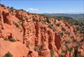 view gallery view gallerySW7.9 km | Nebo Loop Scenic Byway ~ Devil's Kitchen in National Scenic Byways Here, after parking and hiking a short distance on a level paved trail, you will view a miniature version of the famous Bryce Canyon. posted by: brwhiz location: Utah date approved: 12/03/2013 last visited: 04/02/2017 |
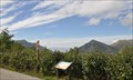
 view gallery view gallery W8 km W8 km
| Nebo Loop Scenic Byway ~ Monument/Nebo Bench Trailhead in National Scenic Byways This is one of several spots along the length of the Byway where you can park and partake of the fresh air by hiking a trail and viewing the fantastic scenery at greater length and in more detail. You have your choice of two trails at this point. posted by: brwhiz location: Utah date approved: 12/03/2013 last visited: never |
 view gallery view gallerySW8.2 km | Nebo Loop Scenic Byway ~ Salt Creek Overlook in National Scenic Byways This is one of numerous spots along the length of the Byway where you can get off the highway, stretch your legs, and partake of the fresh air while viewing the Byway's namesake at a fairly close distance. posted by: brwhiz location: Utah date approved: 12/03/2013 last visited: never |
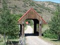 view gallery view gallery E8.4 km E8.4 km
|  Highway '89 Covered Bridge Highway '89 Covered Bridge
in Covered Bridges I travel all over Utah all the time and this is the only covered bridge I've seen in the last year. The bridge is on someone's drive-way. posted by: JacobBarlow location: Utah date approved: 06/16/2007 last visited: 05/20/2014 |
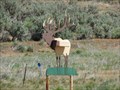 view gallery view galleryE8.5 km |  Elk on '89 Elk on '89
in Themed Homemade Mailboxes A really cool Elk Mailbox. posted by: JacobBarlow location: Utah date approved: 06/13/2007 last visited: 05/20/2014 |
 view gallery view galleryW8.7 km | Nebo Loop Scenic Byway ~ Mount Nebo Overlook in National Scenic Byways This is one of numerous spots along the length of the Byway where you can get off the highway, stretch your legs, and partake of the fresh air while viewing the Byway's namesake at a fairly close distance. posted by: brwhiz location: Utah date approved: 12/03/2013 last visited: never |
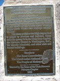 view gallery view gallery NE10.3 km NE10.3 km
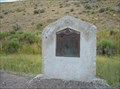
|  Birdseye Marble Quarry Heartbeat of the Canyon Birdseye Marble Quarry Heartbeat of the Canyon
in Utah Historical Markers Originally operated by the Mormon Church and other from the 1880's to the 1940's. posted by: JacobBarlow location: Utah date approved: 09/11/2007 last visited: 09/06/2021 |
 view gallery view gallery SE11.3 km SE11.3 km
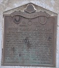
| Given Family Massacre in Utah Historical Markers In the spring of 1865 John Given and his wife Eliza and their four children, John Jr., Mary, Anna, and Martha settled in the meadowland about 110 feet west of here. They built a cabin and willow shanty... posted by: JacobBarlow location: Utah date approved: 08/28/2007 last visited: 08/09/2015 |
 view gallery view gallerySE11.3 km |  Given Family Massacre - 227 Given Family Massacre - 227
in D.U.P. Historic Markers In the spring of 1865 John Given and his wife Eliza and their four children, John Jr., Mary, Anna, and Martha settled in the meadowland about 110 feet west of here. posted by:  Mooroid Mooroid location: Utah date approved: 08/01/2011 last visited: 09/07/2016 |
 view gallery view gallerySE11.3 km |  Given Family Massacre, Utah County, Utah ~ USA Given Family Massacre, Utah County, Utah ~ USA
in Human Migration Monuments The Given family were migrants that settled outside of a fortified established settlement. They became early victims of the Black Hawk War, which took the lives of about 75 pioneer settlers in central Utah. posted by: brwhiz location: Utah date approved: 11/19/2012 last visited: 08/09/2015 |
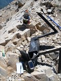
 view gallery view galleryW12.1 km |  Mount Nebo - Wasatch Mountains - Utah County, UT Mount Nebo - Wasatch Mountains - Utah County, UT
in Geographic High Points Although not as popular a hike as Mount Timpanogos, its neighbor in the north part of the county, Mount Nebo, is in fact, the high point in the Utah County section of the Wasatch Mountains. posted by: Chasing Blue Sky location: Utah date approved: 09/04/2013 last visited: 08/20/2016 |
 view gallery view galleryW12.1 km |  Mount Nebo - Wasatch Mountains - Utah County, UT Mount Nebo - Wasatch Mountains - Utah County, UT
in Mountain Summits Although not as popular a hike as Mount Timpanogos, its neighbor in the north part of the county, Mount Nebo, is in fact, the high point in the Utah County section of the Wasatch Mountains. posted by: Chasing Blue Sky location: Utah date approved: 08/23/2013 last visited: 08/20/2016 |
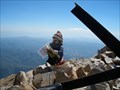
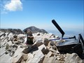
 view gallery view galleryW12.1 km |  Mount Nebo - Wasatch Mountains - Utah County, UT Mount Nebo - Wasatch Mountains - Utah County, UT
in Summit Registers This summit register is on Mount Nebo, which is the high point in the Utah County section of the Wasatch Mountains; although it is not as popular a hike as Mount Timpanogos, its neighbor in the north part of the county. posted by: Chasing Blue Sky location: Utah date approved: 08/22/2013 last visited: 08/20/2016 |
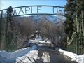 view gallery view galleryNW14 km |  Gateway Arch - Maple Dell Scout Camp - Payson, UT, USA Gateway Arch - Maple Dell Scout Camp - Payson, UT, USA
in Freestanding Arches This gateway arch is at the entrance to Maple Dell Scout Camp, located in Payson Canyon, along the scenic Nebo Loop, south of Payson, Utah. posted by: Chasing Blue Sky location: Utah date approved: 02/25/2013 last visited: 04/02/2017 |
 view gallery view galleryNW14 km |  Maple Dell Scout Camp Maple Dell Scout Camp
in Boy Scout Camps Maple Dell Scout Camp - Utah National Parks Council posted by: firennice location: Utah date approved: 02/27/2011 last visited: 04/02/2017 |
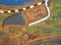 view gallery view galleryNW14 km | You Are Here - Maple Dell Scout Camp - Payson, UT, USA in 'You Are Here' Maps This "You Are Here" is on an orientation map of the Maple Dell Scout Camp, located in Payson Canyon, along the scenic Nebo Loop, south of Payson, Utah. posted by: Chasing Blue Sky location: Utah date approved: 02/25/2013 last visited: 04/02/2017 |
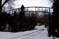
 view gallery view galleryNW14 km |  Historic Camp Bell - Maple Dell Scout Camp - Payson, UT, USA Historic Camp Bell - Maple Dell Scout Camp - Payson, UT, USA
in Scouts Monuments and Memorials This historical marker is attached to the mount for the Historic Camp Bell, situated near the lake at Maple Dell Scout Camp, located in Payson Canyon, along the scenic Nebo Loop, south of Payson, Utah. posted by: Chasing Blue Sky location: Utah date approved: 02/26/2013 last visited: 04/02/2017 |
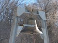 view gallery view galleryNW14 km |  Historic Camp Bell - Maple Dell Scout Camp - Payson, UT, USA Historic Camp Bell - Maple Dell Scout Camp - Payson, UT, USA
in Bells This historic bell is situated near the lake at Maple Dell Scout Camp, located in Payson Canyon, along the scenic Nebo Loop, south of Payson, Utah. posted by: Chasing Blue Sky location: Utah date approved: 02/25/2013 last visited: 04/02/2017 |
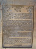 view gallery view galleryNW14 km |  FIRST Service Project by Tu-Cubin-Noonie Lodge - Maple Dell Scout Camp - Payson, UT, USA FIRST Service Project by Tu-Cubin-Noonie Lodge - Maple Dell Scout Camp - Payson, UT, USA
in First of its Kind This historical marker, relates the first service project completed by the Tu-Cubin-Noonie Lodge of the Order of the Arrow. The marker is on the mount for the Historic Camp Bell, at Maple Dell Scout Camp, located in Payson Canyon, near Payson, Utah. posted by: Chasing Blue Sky location: Utah date approved: 02/25/2013 last visited: 04/02/2017 |
 view gallery view galleryNW14 km | Historic Camp Bell - Maple Dell Scout Camp - Payson, UT, USA in Utah Historical Markers This marker is attached to the mount for the Historic Camp Bell, situated near the lake at Maple Dell Scout Camp, located in Payson Canyon, along the scenic Nebo Loop, south of Payson, Utah. posted by: Chasing Blue Sky location: Utah date approved: 02/25/2013 last visited: 04/02/2017 |
|