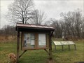
 view gallery view gallery E4.2 km E4.2 km
|   Rachel Carson Conservation Park - Brookville, Maryland Rachel Carson Conservation Park - Brookville, Maryland
in Hiking and walking trailheads Located along the northbound side of Zion Road. posted by:  flyingmoose flyingmoose location: Maryland date approved: 07/05/2022 last visited: 12/04/2022 |
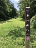 view gallery view gallery S4.8 km S4.8 km
| North Branch Trail - Olney, Maryland in Hiking and walking trailheads Located on the northbound side of Muncaster Road. posted by: flyingmoose location: Maryland date approved: 07/29/2021 last visited: 10/11/2021 |
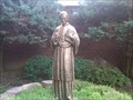 view gallery view gallery SW5.6 km SW5.6 km
|  St. John Neumann - Gaithersburg, MD St. John Neumann - Gaithersburg, MD
in Statues of Religious Figures Saint John Nepomucene Neumann, C.Ss.R. was a Redemptorist missionary to the United States who became the fourth Bishop of Philadelphia (1852–60). He is the only male U.S. citizen to be canonized. (06/2011). Statue is located at entrance to church. posted by: Navy72 location: Maryland date approved: 06/23/2011 last visited: 06/25/2011 |
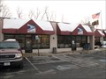
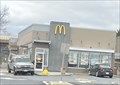 view gallery view galleryS6 km |  McDonald's - Woodfield Rd. - Gaithersburg, MD McDonald's - Woodfield Rd. - Gaithersburg, MD
in McDonald's Restaurants A McDonald's in Gaithersburg, Maryland. posted by: bluesnote location: Maryland date approved: 12/30/2023 last visited: never |
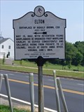 view gallery view galleryE6.3 km |  Elton Elton
in Maryland Historical Markers Located near the intersection Georgia Avenue and New Hampshire Avenue. posted by: flyingmoose location: Maryland date approved: 06/08/2006 last visited: 11/20/2010 |
 view gallery view galleryE6.3 km |  Brookeville, MD 22311 Brookeville, MD 22311
in U.S. Post Offices BrookevillePost Office posted by: Zekester & Simon location: Maryland date approved: 12/23/2009 last visited: 12/28/2023 |
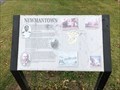 view gallery view galleryS6.6 km |  Newmantown - Derwood, Maryland Newmantown - Derwood, Maryland
in Signs of History Located near the lower parking lot within the Agricultural History Farm Park. posted by: flyingmoose location: Maryland date approved: 11/27/2021 last visited: 11/28/2021 |
 view gallery view gallery SE7.2 km SE7.2 km
| Oakley Cabin - Brookeville MD in Signs of History This log structure, acquired as part of Reddy Branch Stream Valley Park, was once part of Oakley Farm. Built before or just after emancipation, the cabin is representative of slave or tenant housing and is a rare surviving example. posted by:  Don.Morfe Don.Morfe location: Maryland date approved: 04/05/2020 last visited: 10/19/2023 |
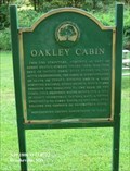 view gallery view gallerySE7.2 km |  Oakley Cabin - Brookeville MD Oakley Cabin - Brookeville MD
in Civil Rights Memorials This log structure, acquired as part of Reddy Branch Stream Valley Park, was once part of Oakley Farm. Built before or just after emancipation, the cabin is representative of slave or tenant housing and is a rare surviving example. posted by: Don.Morfe location: Maryland date approved: 10/15/2022 last visited: 10/19/2023 |
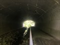 view gallery view galleryS7.7 km |  Wildlife Tunnel - Derwood, Maryland Wildlife Tunnel - Derwood, Maryland
in Man-made Animal Bridges and Crossings Wildlife Tunnel Located under Airpark Road posted by: flyingmoose location: Maryland date approved: 07/29/2021 last visited: 05/20/2023 |
 view gallery view gallerySE8 km |  Brookeville Prisoners Paroled - Brookeville MD Brookeville Prisoners Paroled - Brookeville MD
in Civil War Discovery Trail Sites On June 28, 1863, Confederate Gen. J.E.B. Stuart left Rockville with three cavalry brigades, 125 captured Union supply wagons, and more than 400 military and civilian prisoners, arriving in Brookeville that night. posted by: Don.Morfe location: Maryland date approved: 04/06/2020 last visited: 10/19/2023 |
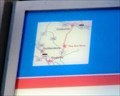 view gallery view gallerySE8 km |  You Are Here Maps - Brookeville MD You Are Here Maps - Brookeville MD
in 'You Are Here' Maps The You Are Here map shows that you are at 5 High Street, Brookeville, MD USA 20833 posted by: Don.Morfe location: Maryland date approved: 03/30/2023 last visited: 10/19/2023 |
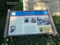 view gallery view gallerySE8 km | Brookeville Prisoners Paroled - Brookeville MD in U.S. Civil War Sites On June 28, 1863, Confederate Gen. J.E.B. Stuart left Rockville with three cavalry brigades, 125 captured Union supply wagons, and more than 400 military and civilian prisoners, arriving in Brookeville that night. posted by: Don.Morfe location: Maryland date approved: 04/03/2023 last visited: 10/19/2023 |
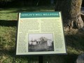 view gallery view gallerySE8 km | Newlin’s Mill Millstone - Brookeville MD in Signs of History Newlin's Mill was located on the west side of Brookeville in the vicinity of Brookeville Road and Market Street (Route 97) and was operated from the early 19th century to the early 20th century. posted by: Don.Morfe location: Maryland date approved: 03/31/2023 last visited: 10/19/2023 |
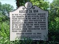 view gallery view gallerySE8 km |  August 26, 1814 - Brookville, Maryland August 26, 1814 - Brookville, Maryland
in War of 1812 Marker in downtown Brookville posted by: flyingmoose location: Maryland date approved: 10/02/2020 last visited: 10/19/2023 |
 view gallery view gallerySE8 km | August 26, 1814 in Maryland Historical Markers This marker resides on the northbound side of Georgia Avenue. posted by: flyingmoose location: Maryland date approved: 06/08/2006 last visited: 10/19/2023 |
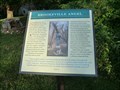 view gallery view gallerySE8 km | Brookeville Angel - Brookeville MD in Signs of History Brookeville Angel
Sculptor Stefan Saal created the Brookeville Angel over a three-month period in 1994 from a white oak tree (Quercus alba) located on the east side of Georgia Avenue (Rt. #97) south of town. posted by: Don.Morfe location: Maryland date approved: 03/31/2023 last visited: 10/19/2023 |
 view gallery view gallery W8.2 km W8.2 km
|  Wind Harps - Damascus, MD Wind Harps - Damascus, MD
in Outdoor Wind Harps Set of three harps in a country park while create a sound when the wind blows. posted by: vhasler location: Maryland date approved: 03/05/2012 last visited: 08/04/2018 |
 view gallery view galleryW8.2 km |  Wind Harps - Damascus, MD Wind Harps - Damascus, MD
in Smithsonian Art Inventory Sculptures When the wind blows, these set of three harps are to create a sound. posted by: vhasler location: Maryland date approved: 03/06/2012 last visited: 07/04/2014 |
 view gallery view gallery N9 km N9 km
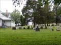
|  Jennings Chapel United Methodist Churchyard Cemetery - Woodbine MD Jennings Chapel United Methodist Churchyard Cemetery - Woodbine MD
in Churchyard Cemeteries The Pastor is David Norton and Sunday service is 9:00 AM. The church has a cemetery and it is located behind and beside the church. posted by: Don.Morfe location: Maryland date approved: 08/01/2021 last visited: 08/27/2021 |
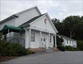 view gallery view galleryN9 km |  Jennings Chapel United Methodist Church - Woodbine MD Jennings Chapel United Methodist Church - Woodbine MD
in Methodist Churches The Pastor is David Norton and Sunday service is 9:00 AM. The church has a cemetery and it is located behind the church. posted by: Don.Morfe location: Maryland date approved: 08/01/2021 last visited: 08/27/2021 |
 view gallery view galleryW9 km |  Stan Miller - Damascus, MD Stan Miller - Damascus, MD
in Ghost Bikes Stan was killed in 2010 by a drunk driver while almost home on his bicycle. This memorial is seen along Ridge Road. posted by: vhasler location: Maryland date approved: 03/08/2012 last visited: 04/15/2012 |
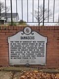 view gallery view gallery NW9.3 km NW9.3 km
| Damascus - Damascus, MD in Maryland Historical Markers Located on a wall along the eastbound side of Route 108 at the intersection of Woodfield Road. posted by: flyingmoose location: Maryland date approved: 11/28/2021 last visited: 02/07/2022 |
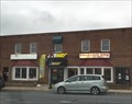 view gallery view galleryNW9.3 km |  Subway - Main St. - Damascus, MD Subway - Main St. - Damascus, MD
in Subway Restaurants A Subway near the center of town. posted by: bluesnote location: Maryland date approved: 01/05/2016 last visited: 01/05/2016 |
 view gallery view galleryNW9.5 km |  Pizza Hut - Main St. - Damascus, MD Pizza Hut - Main St. - Damascus, MD
in Pizza Hut Restaurants A Pizza Hut near the center of town. posted by: bluesnote location: Maryland date approved: 01/05/2016 last visited: 01/05/2016 |
|