 view gallery view gallery S0.6 km S0.6 km
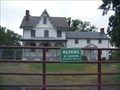
|   Todd Farmhouse (Fort Howard, Maryland) Todd Farmhouse (Fort Howard, Maryland)
in Wikipedia Entries In 1664, Thomas Todd made the first purchase of land in what would become over 1000 acres of Baltimore County. During the War of 1812, the house, which overlooks Shallow Creek and the Chesapeake Bay, was used by the Todd family as a lookout point. posted by:  Don.Morfe Don.Morfe location: Maryland date approved: 09/12/2021 last visited: 01/29/2022 |
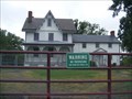 view gallery view galleryS0.6 km |  Todd Farmhouse - Fort Howard MD Todd Farmhouse - Fort Howard MD
in U.S. National Register of Historic Places In 1664, Thomas Todd made the first purchase of land in what would become over 1000 acres of Baltimore County. During the War of 1812, the house, which overlooks Shallow Creek and the Chesapeake Bay, was used by the Todd family as a lookout point. posted by: Don.Morfe location: Maryland date approved: 01/10/2021 last visited: 09/11/2021 |
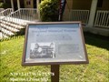
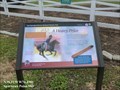 view gallery view galleryS0.6 km |  A Heavy Price Star-Spangled Banner National Historic Trail - Sparrows Point, MD A Heavy Price Star-Spangled Banner National Historic Trail - Sparrows Point, MD
in War of 1812 Private Bernard Todd paid dearly for having his home used for military purposes. posted by: Don.Morfe location: Maryland date approved: 03/19/2020 last visited: 11/02/2021 |
 view gallery view galleryS0.6 km |  A Heavy Price Star-Spangled Banner National Historic Trail - Sparrows Point, MD A Heavy Price Star-Spangled Banner National Historic Trail - Sparrows Point, MD
in Signs of History Private Bernard Todd paid dearly for having his home used for military purposes. posted by: Don.Morfe location: Maryland date approved: 09/01/2022 last visited: 01/16/2023 |
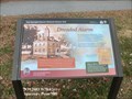
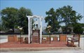
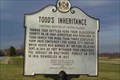 view gallery view galleryS0.6 km |  Todd's Inheritance Todd's Inheritance
in Maryland Historical Markers Todd's Farmhouse
Listed 10/18/1973
Address 9000 Old North Point Rd. Ft. Howard, MD
Period of Significance 1800-1824, 1825-1849 posted by:  Fritz_Monroe Fritz_Monroe location: Maryland date approved: 03/09/2006 last visited: 08/20/2021 |
 view gallery view gallery E0.6 km E0.6 km
|  Unexpected Resistance - Sparrows Point MD Unexpected Resistance - Sparrows Point MD
in Battlefields The marker is located in North Point State Park on Old Bay Shore Road, Sparrows Point, MD United States 21219. posted by: Don.Morfe location: Maryland date approved: 09/14/2023 last visited: 07/15/2020 |
 view gallery view galleryE0.6 km |  'You Are Here' Maps-Unexpected Resistance - Sparrows Point MD 'You Are Here' Maps-Unexpected Resistance - Sparrows Point MD
in 'You Are Here' Maps The 'You Are Here' Map shows that you are in North Point State Park on Old Bay Shore Road, Sparrows Point, MD United States 21219. posted by: Don.Morfe location: Maryland date approved: 09/13/2023 last visited: 09/16/2023 |
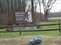
 view gallery view galleryE0.6 km | Unexpected Resistance Star-Spangled Banner National Historic Trail - Sparrows Point MD in Signs of History British troops landing at North Point on September 12, 1814, could almost taste victory. Three weeks earlier they defeated the Americans at Bladensburg and invaded Washington. posted by: Don.Morfe location: Maryland date approved: 09/01/2022 last visited: 01/16/2023 |
 view gallery view galleryE0.6 km | Unexpected Resistance Star-Spangled Banner National Historic Trail - Sparrows Point MD in War of 1812 British troops landing at North Point on September 12, 1814, could almost taste victory. Three weeks earlier they defeated the Americans at Bladensburg and invaded Washington. posted by: Don.Morfe location: Maryland date approved: 03/19/2020 last visited: 11/02/2021 |
 view gallery view galleryE0.8 km |  North Point State Park - Edgemere MD North Point State Park - Edgemere MD
in State/Provincial Parks This 1,310 acre park in Edgemere was once the site of the Bay Shore Amusement Park, a popular destination for summer visitors from 1906 to 1947. posted by: Don.Morfe location: Maryland date approved: 09/01/2022 last visited: 01/16/2023 |
 view gallery view galleryE0.8 km |  Former Bay Shore Amusement Park - Edgemere MD Former Bay Shore Amusement Park - Edgemere MD
in Defunct Amusement Parks North Point State Park, a 1,310 acre park in Edgemere was once the site of the Bay Shore Amusement Park, a popular destination for summer visitors from 1906 to 1947. posted by: Don.Morfe location: Maryland date approved: 09/08/2022 last visited: 01/16/2023 |
 view gallery view galleryS1.1 km | The Landing Star-Spangled Banner National Historic Trail - Fort Howard MD in War of 1812 Transport ships carrying a British invasion force arrived in Old Road Bay, September 11, 1814. posted by: Don.Morfe location: Maryland date approved: 03/19/2020 last visited: 11/02/2021 |
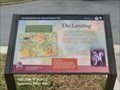 view gallery view galleryS1.1 km | The Landing Star-Spangled Banner National Historic Trail - Fort Howard MD in Signs of History Transport ships carrying a British invasion force arrived in Old Road Bay, September 11, 1814. posted by: Don.Morfe location: Maryland date approved: 09/01/2022 last visited: 01/16/2023 |
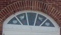 view gallery view galleryS1.3 km |  Stained Glass Window above the front door - Fort Howard Community Church - Fort Howard MD Stained Glass Window above the front door - Fort Howard Community Church - Fort Howard MD
in Stained Glass Windows The stained Glass Window above the front door of the church. Fort Howard Community Church is a Gospel-Centered Ministry in Fort Howard, Maryland, located on North Point Peninsula in Baltimore County. posted by: Don.Morfe location: Maryland date approved: 07/20/2021 last visited: 08/28/2021 |
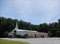
 view gallery view galleryS1.3 km |  Fort Howard Community Church - Fort Howard MD Fort Howard Community Church - Fort Howard MD
in Baptist Churches Fort Howard Community Church is a Gospel-Centered Ministry in Fort Howard, Maryland, located on North Point Peninsula in Baltimore County. We partner with the SBC and affirm The Baptist Faith and Message (2000). posted by: Don.Morfe location: Maryland date approved: 07/20/2021 last visited: 08/28/2021 |
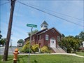
 view gallery view galleryS1.3 km |  Fort Howard, Maryland 21052 Fort Howard, Maryland 21052
in U.S. Post Offices This a small post office located on 9200 Fort Howard Ave, Fort Howard MD. 21052 posted by: Don.Morfe location: Maryland date approved: 07/20/2021 last visited: 08/28/2021 |
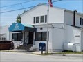 view gallery view galleryS1.3 km | Fort Howard, Maryland in Wikipedia Entries Fort Howard is an unincorporated community and census-designated place in Baltimore County. The GPS Coordinates are for the Fort Howard U.S. Post Office located at 9200 Fort Howard Ave, Fort Howard MD. 21052. posted by: Don.Morfe location: Maryland date approved: 12/02/2023 last visited: 07/15/2020 |
 view gallery view gallery N1.4 km N1.4 km
|  St. John's Evangelical Lutheran Church - Dundalk MD St. John's Evangelical Lutheran Church - Dundalk MD
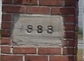
in Lutheran Churches Text on the Cornerstone in front of the church: St. John’s Ev. Lutheran Church Rebuilt 1920 ISA. XXVII:3 posted by: Don.Morfe location: Maryland date approved: 07/20/2021 last visited: 08/28/2021 |
 view gallery view gallery SE1.6 km SE1.6 km
| Dreaded Alarm Star-Spangled Banner National Historic Trail - Sparrows Point MD in War of 1812 The cupola atop the Ridgely house, c. 1767 farmhouse located near here, served as a lookout station in 1813 and 1814, operated by Major Josiah Green. posted by: Don.Morfe location: Maryland date approved: 03/18/2020 last visited: 11/02/2021 |
 view gallery view gallerySE1.6 km | Dreaded Alarm Star-Spangled Banner National Historic Trail - Sparrows Point MD in Signs of History The cupola atop the Ridgely house, c. 1767 farmhouse located near here, served as a lookout station in 1813 and 1814, operated by Major Josiah Green. posted by: Don.Morfe location: Maryland date approved: 09/01/2022 last visited: 01/16/2023 |
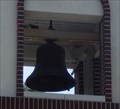 view gallery view galleryN1.8 km |  Bell Tower St. Luke Catholic Church - Edgemere MD Bell Tower St. Luke Catholic Church - Edgemere MD
in Bell Towers The bell tower is at the extreme left of St. Luke Catholic Church. The bell is named "Saint Edward's Bell" in memory of Edward Lee Mason III, posted by: Don.Morfe location: Maryland date approved: 08/17/2021 last visited: 08/25/2021 |
 view gallery view galleryN1.8 km | St. Luke Catholic Church - Edgemere MD in Roman Catholic Churches Our Lady of Hope and St. Luke Parishes are two Roman Catholic faith communities that serve the people of Southeastern Baltimore County. We are deeply rooted in the history and tradition of the Dundalk and Edgemere community, posted by: Don.Morfe location: Maryland date approved: 08/18/2021 last visited: 08/25/2021 |
 view gallery view gallerySE1.8 km | The Rebirth of a Maryland Historical Treasure - Sparrows Point, MD in Signs of History Originally built in 1906 by the United Railways and Electric Company on this site, stood the once grand Bay Shore Park Restaurant. posted by: Don.Morfe location: Maryland date approved: 01/19/2020 last visited: 09/25/2021 |
 view gallery view galleryN1.8 km |  Shrine of Mary, Mother of Jesus at St. Luke Catholic Church - Edgemere MD Shrine of Mary, Mother of Jesus at St. Luke Catholic Church - Edgemere MD
in Statues of Religious Figures The Shrine of Mary, Mother of Jesus is located on the grounds of St. Luke Catholic Church. It is in front of the church as you enter the parking lot. The cornerstone (1888) of the original St. Luke Church is embedded in the brick pedestal. posted by: Don.Morfe location: Maryland date approved: 08/17/2021 last visited: 08/25/2021 |
 view gallery view galleryN1.8 km |  1888 - From the Original St. Luke Catholic Church - Edgemere MD 1888 - From the Original St. Luke Catholic Church - Edgemere MD
in Dated Buildings and Cornerstones The cornerstone (1888) of the original St. Luke Church is embedded in the brick pedestal that holds the statue of Mary, Mother of Jesus. posted by: Don.Morfe location: Maryland date approved: 08/17/2021 last visited: 08/25/2021 |
|