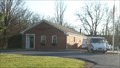
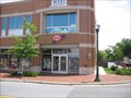
 view gallery view gallery SE1.8 km SE1.8 km
|   Boyds, Maryland 20841 Boyds, Maryland 20841
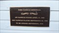
in U.S. Post Offices This post office serves the historic town of Boyds, Maryland. posted by:  HaricotVert_52 HaricotVert_52 location: Maryland date approved: 11/29/2009 last visited: 09/24/2010 |
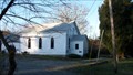
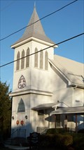 view gallery view gallerySE2.1 km |  Boyds Presbyterian Church - Boyds, Maryland Boyds Presbyterian Church - Boyds, Maryland
in Presbyterian Churches Boyds Presbyterian Church was built in 1876 when the town of Boyds grew up around a railroad construction village upon the opening of the B&O Metropolitan line. The building has been used continually for worship as well as the town hall at one time. posted by: HaricotVert_52 location: Maryland date approved: 12/02/2009 last visited: 09/24/2010 |
 view gallery view gallerySE2.1 km |  1876 - Boyds Presbyterian Church - Boyds MD 1876 - Boyds Presbyterian Church - Boyds MD
in Dated Buildings and Cornerstones Boyds Presbyterian Church was built in 1876 when the town of Boyds grew up around a railroad construction village upon the opening of the B&O Metropolitan line. posted by: HaricotVert_52 location: Maryland date approved: 12/02/2009 last visited: 09/24/2010 |
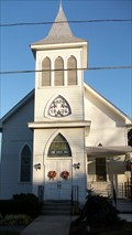
 view gallery view gallerySE2.1 km | 1893 - St Mark's United Methodist Church - Boyds, MD in Dated Buildings and Cornerstones St Mark's United Methodist Church was founded by a community of former slaves and is located on White Ground Road in the historic district of Boyds, Maryland.
posted by: HaricotVert_52 location: Maryland date approved: 12/02/2009 last visited: 09/24/2010 |
 view gallery view gallerySE2.1 km |  St Mark's United Methodist Church - Boyds, MD St Mark's United Methodist Church - Boyds, MD
in Methodist Churches St Mark's United Methodist Church located on White Ground Road is part of the historic district of Boyds, Maryland. posted by: HaricotVert_52 location: Maryland date approved: 12/01/2009 last visited: 09/24/2010 |
 view gallery view gallerySE2.1 km |  Time Capsule at St Marks Methodist Church - Boyds MD Time Capsule at St Marks Methodist Church - Boyds MD
in Time Capsules This time capsule is at St Mark's Methodist Church located in the historic district of Boyds, Maryland. posted by: HaricotVert_52 location: Maryland date approved: 11/30/2009 last visited: 09/24/2010 |
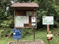
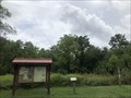 view gallery view gallerySE2.1 km |  Hoyles Mill Trail (White Ground Road) - Boyds, Maryland Hoyles Mill Trail (White Ground Road) - Boyds, Maryland
in Hiking and walking trailheads Located on the northbound side of White Ground Road. posted by: flyingmoose location: Maryland date approved: 08/18/2021 last visited: 02/27/2022 |
 view gallery view gallery E3.4 km E3.4 km
|  Black Hill Park - Boyds MD Black Hill Park - Boyds MD
in Nature Centers The Black Hill Nature Center is open year-round and offers exhibits about the flora and fauna of the area. Naturalists also offer seasonal pontoon boat tours and educational programs. posted by: HaricotVert_52 location: Maryland date approved: 09/10/2009 last visited: 09/24/2010 |
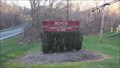 view gallery view gallerySE3.9 km |  "Home in the Country" - Boyds, Maryland "Home in the Country" - Boyds, Maryland
in Welcome Signs This welcome sign for Boyds, Maryland, can be found on the southern approach to Boyds along Barnesville Road (MD 117). posted by: HaricotVert_52 location: Maryland date approved: 11/30/2009 last visited: 01/01/2013 |
 view gallery view galleryE3.9 km |  Dog Park @ Black Hill Park - Boyds MD Dog Park @ Black Hill Park - Boyds MD
in Off-Leash Dog Areas Pets are welcome at Black Hill Park. As long as they are on a leash, they can visit the picnic areas and trails. A designated enclosed run is available for dogs at parking area #6 for off-leash exercise and socialization. posted by: HaricotVert_52 location: Maryland date approved: 09/10/2009 last visited: 09/24/2010 |
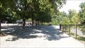
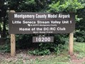 view gallery view gallery S4.3 km S4.3 km
|  Montgomery County Model Airpark - Boyds, Maryland Montgomery County Model Airpark - Boyds, Maryland
in Model Aircraft Fields Located on the eastbound side of Schaeffer Road. posted by: flyingmoose location: Maryland date approved: 08/17/2021 last visited: never |
 view gallery view gallery NW5 km NW5 km
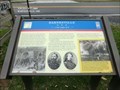
|  Barnesville “Before night our town changed hands five times!” - Barnesville MD Barnesville “Before night our town changed hands five times!” - Barnesville MD
in Civil War Discovery Trail Sites On the evening of September 5, 1862, Gen. Wade Hampton’s and Gen. Fitzhugh Lee’s Confederate cavalry brigades bivouacked around Barnesville. posted by:  Don.Morfe Don.Morfe location: Maryland date approved: 03/22/2020 last visited: 10/08/2021 |
 view gallery view galleryNW5 km | Barnesville “... a bad night of it...” - Barnesville, MD in Civil War Discovery Trail Sites The advance of Union Gen. John F. Reynolds’ I Corps began slogging through Barnesville on the morning of Friday, June 26, 1863, having crossed the Potomac River the afternoon before and camped west of town. posted by: Don.Morfe location: Maryland date approved: 03/22/2020 last visited: 10/08/2021 |
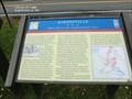
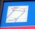
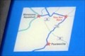 view gallery view galleryNW5 km |  You Are Here Map - Barnesville “… a bad night of it…” - Barnesville MD You Are Here Map - Barnesville “… a bad night of it…” - Barnesville MD
in 'You Are Here' Maps The You Are Here Map shows that you are at the intersection of Barnesville Road and West Harris Road in Barnesville MD in the parking lot of the St. Mary’s Church. posted by: Don.Morfe location: Maryland date approved: 03/27/2023 last visited: 04/02/2023 |
 view gallery view galleryNW5 km | Barnesville “… a bad night of it…” - Barnesville MD in U.S. Civil War Sites The advance of Union Gen. John F. Reynolds’ I Corps began slogging through Barnesville on the morning of Friday, June 26, 1863, having crossed the Potomac River the afternoon before and camped west of town. posted by: Don.Morfe location: Maryland date approved: 03/27/2023 last visited: 04/02/2023 |
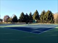 view gallery view galleryE5.1 km |  Water's Landing Park Tennis Courts - Germantown, MD Water's Landing Park Tennis Courts - Germantown, MD
in Tennis Facilities A small tennis facility in a small DC Suburb. posted by: bluesnote location: Maryland date approved: 01/09/2015 last visited: 01/09/2015 |
 view gallery view galleryS6 km |  Schaeffer Farms - Germantown, Maryland Schaeffer Farms - Germantown, Maryland
in Mountain Bike Trailheads Located off of Schaeffer Road. posted by: flyingmoose location: Maryland date approved: 08/18/2021 last visited: never |
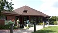
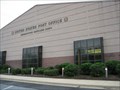
 view gallery view galleryE6 km | 1891 - Germantown Railroad Station - Germantown MD in Dated Buildings and Cornerstones The 1873 opening of the Metropolitan branch of the B&O Railroad into Washington DC, brought the centers of business in rural areas to the railroad line. Many towns built stations like this to serve the daily passenger & freight service. posted by: HaricotVert_52 location: Maryland date approved: 12/03/2009 last visited: 05/21/2010 |
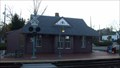 view gallery view galleryE6 km |  Germantown Railroad Station - Germantown MD Germantown Railroad Station - Germantown MD
in Train Stations/Depots The 1873 opening of the Metropolitan branch of the B&O Railroad into Washington DC, brought the centers of business in rural areas to the railroad line. Many towns built stations like this to serve the daily passenger & freight service. posted by: HaricotVert_52 location: Maryland date approved: 12/03/2009 last visited: 09/29/2010 |
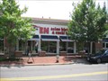
 view gallery view galleryE6.1 km |  AAA Midatlantic - Germantown, MD AAA Midatlantic - Germantown, MD
in Auto Clubs The AAA office in the Germantown Town Center, in Maryland, is a full service office. posted by: HaricotVert_52 location: Maryland date approved: 06/29/2009 last visited: 05/21/2010 |
 view gallery view galleryE6.1 km |  EN Asian Bistro and Sushi Bar - Germantown MD EN Asian Bistro and Sushi Bar - Germantown MD
in Sushi Restaurants "EN" means the coming together of people. That represents both the gathering of people to dine here, and the coming together of fine Chinese and Japanese dishes. posted by: HaricotVert_52 location: Maryland date approved: 07/01/2009 last visited: 05/21/2010 |
 view gallery view galleryE6.1 km | Germantown, MD - 20874 in U.S. Post Offices A post office in Germantown, MD. This is the main post office. It's located on Wisteria Drive. posted by: saopaulo1 location: Maryland date approved: 05/14/2009 last visited: 05/21/2010 |
 view gallery view gallery N6.3 km N6.3 km
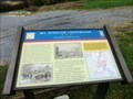
| Mt. Ephraim Crossroads Sharpshooters Hold the Line - Dickerson, MD in Civil War Discovery Trail Sites You are looking at Sugarloaf Mountain, where the running cavalry fight that began in the late afternoon on September 9, 1862, in Barnesville came to a halt. posted by: Don.Morfe location: Maryland date approved: 03/27/2020 last visited: 10/08/2021 |
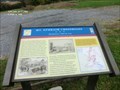
 view gallery view galleryN6.3 km | Mt. Ephraim Crossroads - Comus MD in 'You Are Here' Maps You Are Hear map shows that you are at the foot of Sugarloaf Mountain on Comus Road. It is located in the rear of a parking lot for the Comus Inn at 23900 Old Hundred Rd, Dickerson MD 20842 posted by: Don.Morfe location: Maryland date approved: 03/28/2023 last visited: 04/02/2023 |
 view gallery view galleryN6.3 km |  Battle at Sugarloaf Mountain-Mt. Ephraim Crossroads Sharpshooters Hold the Line - Comus MD Battle at Sugarloaf Mountain-Mt. Ephraim Crossroads Sharpshooters Hold the Line - Comus MD
in Battlefields You are looking at Sugarloaf Mountain, where the running cavalry fight that began in the late afternoon on September 9, 1862, in Barnesville came to a halt. posted by: Don.Morfe location: Maryland date approved: 03/29/2023 last visited: 04/02/2023 |
|