 view gallery view gallery E1.6 km E1.6 km
|   Neon Design and Display Neon Design and Display
in Neon Signs Neon for neon! posted by:  Zekester & Simon Zekester & Simon location: Maryland date approved: 12/27/2009 last visited: 10/19/2023 |
 view gallery view gallery NE2.7 km NE2.7 km
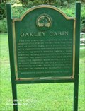
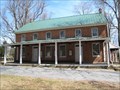
|  Oakley Cabin - Brookeville MD Oakley Cabin - Brookeville MD
in Civil Rights Memorials This log structure, acquired as part of Reddy Branch Stream Valley Park, was once part of Oakley Farm. Built before or just after emancipation, the cabin is representative of slave or tenant housing and is a rare surviving example. posted by:  Don.Morfe Don.Morfe location: Maryland date approved: 10/15/2022 last visited: 10/19/2023 |
 view gallery view galleryNE2.7 km |  Oakley Cabin - Brookeville MD Oakley Cabin - Brookeville MD
in Signs of History This log structure, acquired as part of Reddy Branch Stream Valley Park, was once part of Oakley Farm. Built before or just after emancipation, the cabin is representative of slave or tenant housing and is a rare surviving example. posted by: Don.Morfe location: Maryland date approved: 04/05/2020 last visited: 10/19/2023 |
 view gallery view gallery SW3.2 km SW3.2 km
|  Woodland Mustang - Olney, Maryland Woodland Mustang - Olney, Maryland
in Abandoned Dead Vehicles Abandoned Car along the Kengala Trail. posted by: flyingmoose location: Maryland date approved: 02/18/2021 last visited: 12/30/2020 |
 view gallery view galleryNE3.5 km |  August 26, 1814 August 26, 1814
in Maryland Historical Markers This marker resides on the northbound side of Georgia Avenue. posted by: flyingmoose location: Maryland date approved: 06/08/2006 last visited: 10/19/2023 |
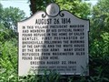 view gallery view galleryNE3.5 km |  August 26, 1814 - Brookville, Maryland August 26, 1814 - Brookville, Maryland
in War of 1812 Marker in downtown Brookville posted by: flyingmoose location: Maryland date approved: 10/02/2020 last visited: 10/19/2023 |
 view gallery view galleryNE3.5 km |  Brookeville Prisoners Paroled - Brookeville MD Brookeville Prisoners Paroled - Brookeville MD
in Civil War Discovery Trail Sites On June 28, 1863, Confederate Gen. J.E.B. Stuart left Rockville with three cavalry brigades, 125 captured Union supply wagons, and more than 400 military and civilian prisoners, arriving in Brookeville that night. posted by: Don.Morfe location: Maryland date approved: 04/06/2020 last visited: 10/19/2023 |
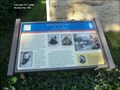 view gallery view galleryNE3.5 km | Brookeville Prisoners Paroled - Brookeville MD in U.S. Civil War Sites On June 28, 1863, Confederate Gen. J.E.B. Stuart left Rockville with three cavalry brigades, 125 captured Union supply wagons, and more than 400 military and civilian prisoners, arriving in Brookeville that night. posted by: Don.Morfe location: Maryland date approved: 04/03/2023 last visited: 10/19/2023 |
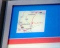 view gallery view galleryNE3.5 km |  You Are Here Maps - Brookeville MD You Are Here Maps - Brookeville MD
in 'You Are Here' Maps The You Are Here map shows that you are at 5 High Street, Brookeville, MD USA 20833 posted by: Don.Morfe location: Maryland date approved: 03/30/2023 last visited: 10/19/2023 |
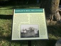 view gallery view galleryNE3.5 km | Newlin’s Mill Millstone - Brookeville MD in Signs of History Newlin's Mill was located on the west side of Brookeville in the vicinity of Brookeville Road and Market Street (Route 97) and was operated from the early 19th century to the early 20th century. posted by: Don.Morfe location: Maryland date approved: 03/31/2023 last visited: 10/19/2023 |
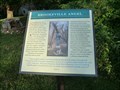 view gallery view galleryNE3.5 km | Brookeville Angel - Brookeville MD in Signs of History Brookeville Angel
Sculptor Stefan Saal created the Brookeville Angel over a three-month period in 1994 from a white oak tree (Quercus alba) located on the east side of Georgia Avenue (Rt. #97) south of town. posted by: Don.Morfe location: Maryland date approved: 03/31/2023 last visited: 10/19/2023 |
 view gallery view gallery NW3.7 km NW3.7 km
|  North Branch Trail - Olney, Maryland North Branch Trail - Olney, Maryland
in Hiking and walking trailheads Located on the northbound side of Muncaster Road. posted by: flyingmoose location: Maryland date approved: 07/29/2021 last visited: 10/11/2021 |
 view gallery view gallery W4.3 km W4.3 km
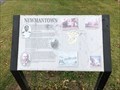
| Newmantown - Derwood, Maryland in Signs of History Located near the lower parking lot within the Agricultural History Farm Park. posted by: flyingmoose location: Maryland date approved: 11/27/2021 last visited: 11/28/2021 |
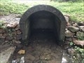
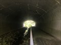 view gallery view galleryW4.8 km |  Wildlife Tunnel - Derwood, Maryland Wildlife Tunnel - Derwood, Maryland
in Man-made Animal Bridges and Crossings Wildlife Tunnel Located under Airpark Road posted by: flyingmoose location: Maryland date approved: 07/29/2021 last visited: 05/20/2023 |
 view gallery view gallery S5 km S5 km
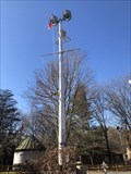
|  U.S.S Robert E. Peary Mast - Rockville, Maryland U.S.S Robert E. Peary Mast - Rockville, Maryland
in Nautical Flag Poles An old mast from the Robert E. Peary destroyer escort ship 1943-1966 resides just outside of the Lathrop E. Smith Center. posted by: flyingmoose location: Maryland date approved: 02/01/2021 last visited: 04/16/2020 |
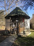 view gallery view galleryS5 km |  Lathrop E. Smith Center Aviary - Rockville, Maryland Lathrop E. Smith Center Aviary - Rockville, Maryland
in Aviaries This Aviary is located at the Lathrop E. Smith Aviary. posted by: flyingmoose location: Maryland date approved: 01/25/2021 last visited: 04/16/2020 |
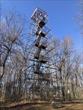 view gallery view gallerySW5 km |  Stanton G. Ernst Observation Tower - Rockville, Maryland Stanton G. Ernst Observation Tower - Rockville, Maryland
in Look-Out Towers An observation tower located at the Lathrop E. Smith Center along Muncaster Mill Road. posted by: flyingmoose location: Maryland date approved: 02/22/2021 last visited: 07/04/2021 |
 view gallery view galleryE5.3 km |  Sandy Springs Friends Meeting House - Sandy Springs MD Sandy Springs Friends Meeting House - Sandy Springs MD
in Quaker Meeting Houses Located in the heart of Sandy Spring is this wonderful meeting house. posted by: flyingmoose location: Maryland date approved: 03/31/2008 last visited: 08/14/2009 |
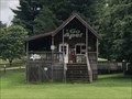 view gallery view gallerySW5.3 km |  Go Ape! - Rockville, Maryland Go Ape! - Rockville, Maryland
in Zip-line Located near the eastern entrance of Lake Needwood. posted by: flyingmoose location: Maryland date approved: 08/29/2021 last visited: 05/21/2023 |
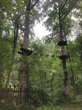 view gallery view gallerySW5.3 km |  Go Ape! - Rockville, Maryland Go Ape! - Rockville, Maryland
in Ropes Course Located near the eastern entrance of Lake Needwood. posted by: flyingmoose location: Maryland date approved: 09/04/2021 last visited: 05/21/2023 |
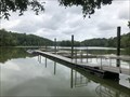 view gallery view gallerySW5.8 km | ") Lake Needwood Boat Shop - Rockville, Maryland Lake Needwood Boat Shop - Rockville, Maryland
in Watercraft Rentals (Human Powered) Located at the south end of the lake off of Needwood Lake Circle. posted by: flyingmoose location: Maryland date approved: 08/20/2021 last visited: 05/21/2023 |
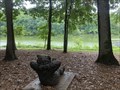 view gallery view gallerySW5.8 km |  Lake Needwood Bear - Rockville, Maryland Lake Needwood Bear - Rockville, Maryland
in Bear Statues Located between the boathouse and parking at Lake Needwood. posted by: flyingmoose location: Maryland date approved: 08/20/2021 last visited: 10/22/2022 |
 view gallery view galleryE6 km |  Sandy Spring - Sandy Spring, Maryland Sandy Spring - Sandy Spring, Maryland
in Natural Springs Located at the end of Meeting House Road. posted by: flyingmoose location: Maryland date approved: 08/21/2021 last visited: 10/11/2021 |
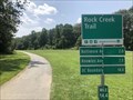 view gallery view gallerySW6 km | Rock Creek Trail (Northern Terminus) - Rockville, Maryland in Hiking and walking trailheads Trailhead located along Needwood Lake Circle. posted by: flyingmoose location: Maryland date approved: 07/29/2021 last visited: 05/20/2023 |
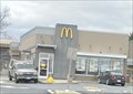 view gallery view galleryW6.1 km |  McDonald's - Woodfield Rd. - Gaithersburg, MD McDonald's - Woodfield Rd. - Gaithersburg, MD
in McDonald's Restaurants A McDonald's in Gaithersburg, Maryland. posted by: bluesnote location: Maryland date approved: 12/30/2023 last visited: never |
|