 view gallery view gallery SW14.6 km SW14.6 km
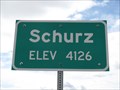
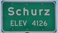
|   Schurtz NV (Northern Approach) - 4126' Schurtz NV (Northern Approach) - 4126'
in Elevation Signs The sign is at the north city limit of Schurtz on Highway 95. posted by:  WR7X WR7X location: Nevada date approved: 03/31/2013 last visited: 09/28/2013 |
 view gallery view gallerySW15.3 km |  Walker River Reservation, Schurz, Nevada Walker River Reservation, Schurz, Nevada
in Nations Within Nations This nation within a nation is on Highway 95 (Veterans Memorial Highway) in Mineral County, Nevada. posted by: Queens Blessing location: Nevada date approved: 12/09/2012 last visited: 05/21/2016 |
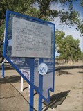
 view gallery view gallerySW15.3 km |  #183 - WALKER RIVER RESERVATION, Schurz, NV #183 - WALKER RIVER RESERVATION, Schurz, NV
in Nevada Historical Markers The Walker River Reservation has a rich history. posted by: Queens Blessing location: Nevada date approved: 12/10/2012 last visited: 05/21/2016 |
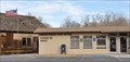 view gallery view gallerySW15.4 km |  Schurz, Nevada 89427 Schurz, Nevada 89427
in U.S. Post Offices This Post Office is located at 4000A US Highway 95 N in Schurz, Nevada. posted by: brwhiz location: Nevada date approved: 01/16/2012 last visited: 09/28/2013 |
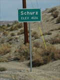 view gallery view gallerySW16.1 km | Schurz NV, USA - elevation 4,126 in Elevation Signs Schurz is located on US Highwy 95 (Veterans Memorial Highway) in Nevada. It is on a reservation. posted by: Queens Blessing location: Nevada date approved: 12/09/2012 last visited: 09/28/2013 |
 view gallery view gallerySW16.3 km | Schurz (Northwest Approach) ~ Elevation 4126 Feet in Elevation Signs This Elevation Sign is located on the southwest side of US Highway 95 at the northwest town limits of Schurz, Nevada. posted by: brwhiz location: Nevada date approved: 05/05/2013 last visited: never |
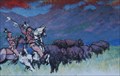 view gallery view gallerySW16.6 km |  God Bless All the Human Beings - Schurz, NV God Bless All the Human Beings - Schurz, NV
in Murals This mural is on the Tribal Headquarters building of the Walker River Reservation in Schurz, Nevada. posted by: Queens Blessing location: Nevada date approved: 12/09/2012 last visited: 04/25/2014 |
 view gallery view gallery N24.3 km N24.3 km
|  Pony Express -- Carson Sink Station Pony Express -- Carson Sink Station
in Pony Express Monuments Marker at the approximate location of the Carson Sink Station. posted by: Left Coast Labs location: Nevada date approved: 09/25/2009 last visited: never |
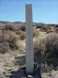 view gallery view gallery NW26.2 km NW26.2 km
| Pony Express Trail - Route Marker in Pony Express Monuments Concrete route marker erected by the BLM between Carson Sink Station and Desert Station. posted by: Left Coast Labs location: Nevada date approved: 09/25/2009 last visited: never |
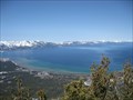 view gallery view gallery W27 km W27 km
|  Lake Tahoe, California / Nevada Lake Tahoe, California / Nevada
in 1000 Places to See Before You Die Lake Tahoe is featured in the Nevada section of the US and Canadian version of 1000 Places to See Before You Die. posted by: saopaulo1 location: Nevada date approved: 04/15/2010 last visited: 09/25/2016 |
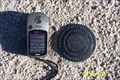 view gallery view gallery NE32 km NE32 km
|  Gote Flat AA 1996 Gravity Control Benchmark Gote Flat AA 1996 Gravity Control Benchmark
in U.S. Benchmarks A gravity control benchmark located at the site of "Project Shoal", an underground nuclear test conducted on October 26, 1963. posted by: Nitro929 location: Nevada date approved: 09/02/2007 last visited: never |
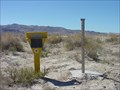
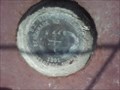 view gallery view galleryN33.8 km | US Navy Geothermal Benchmark # W466 in U.S. Benchmarks This waymark is in my front yard. posted by:  pdons1 pdons1 location: Nevada date approved: 08/14/2007 last visited: 12/29/2008 |
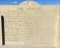 view gallery view galleryNE34.6 km | Sand Mountain in Nevada Historical Markers History sign along U.S. Hwy. 50 at junction to the Sand Mountain Recreation Area. posted by: Volcanoguy location: Nevada date approved: 04/26/2017 last visited: 10/05/2016 |
 view gallery view galleryNW36.5 km | Desert Station in Pony Express Monuments The ruins at Desert Station, east of Fort Churchill, Nevada posted by: Nitro929 location: Nevada date approved: 04/24/2007 last visited: 08/23/2013 |
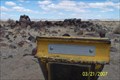
 view gallery view galleryN37.7 km |  Grimes Point Petroglyphs, Nevada Grimes Point Petroglyphs, Nevada
in Pictographs BLM’s Grimes Point Archaeological Area in Nevada. posted by: Volcanoguy location: Nevada date approved: 05/02/2017 last visited: 10/05/2016 |
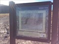
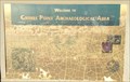 view gallery view galleryN37.7 km | Welcome to Grimes Point Archaeological Area in Nevada Historical Markers History sign at Grimes Point Archaeological Area. posted by: Volcanoguy location: Nevada date approved: 04/26/2017 last visited: 10/05/2016 |
 view gallery view galleryN37.7 km | Grimes Point Archaeological Area in Nevada Historical Markers History sign at Grimes Point Archaeological Area. posted by: Volcanoguy location: Nevada date approved: 04/26/2017 last visited: 10/05/2016 |
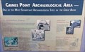
 view gallery view galleryN37.7 km |  Grimes Point - Nevada Grimes Point - Nevada
in U.S. National Register of Historic Places Grimes Point is one of the oldest known petroglyph sites in Nevada. It contains over 150 basalt boulders bearing pecked designs, some of which are at least 8,000 years old. posted by: Volcanoguy location: Nevada date approved: 04/26/2017 last visited: 10/05/2016 |
 view gallery view galleryN37.7 km |  Grimes Point Interpretive Trail - Grimes Point Archaeological Area - Nevada Grimes Point Interpretive Trail - Grimes Point Archaeological Area - Nevada
in Self Guided Walks and Trails Self guided trail at the BLM’s Grimes Point Archaeological Area. posted by: Volcanoguy location: Nevada date approved: 04/28/2017 last visited: 10/05/2016 |
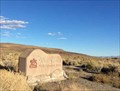
 view gallery view galleryN37.8 km | Grimes Point in Nevada Historical Markers 10 miles east of Fallon on Hwy-50 at the parking area. posted by: Left Coast Labs location: Nevada date approved: 08/21/2009 last visited: 10/05/2016 |
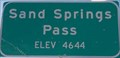 view gallery view galleryNE38.6 km | Sand Springs Pass - Elevation 4644 feet in Elevation Signs Elevation sign at Sand Springs Pass on U.S. Hwy. 50. posted by: Volcanoguy location: Nevada date approved: 04/19/2017 last visited: 10/05/2016 |
 view gallery view galleryN38.8 km |  Hidden Cave Trailhead - Nevada Hidden Cave Trailhead - Nevada
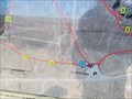
in 'You Are Here' Maps You Are Here marker at Hidden Cave Trailhead. posted by: Volcanoguy location: Nevada date approved: 04/26/2017 last visited: 10/06/2016 |
 view gallery view galleryN38.8 km | Hidden Cave Interpretive Trail - Grimes Point Archaeological Area - Nevada in Self Guided Walks and Trails Self guided trail at the BLM’s Grimes Point Archaeological Area. posted by: Volcanoguy location: Nevada date approved: 04/28/2017 last visited: 10/06/2016 |
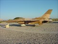 view gallery view galleryN39.4 km |  General Dynamics F-16N -- NAS Fallon, NV General Dynamics F-16N -- NAS Fallon, NV
in Static Aircraft Displays F-16N at the NAS Fallon Aipower Park. posted by: Left Coast Labs location: Nevada date approved: 06/28/2010 last visited: 06/06/2012 |
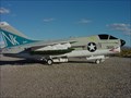 view gallery view galleryN39.4 km | LTV A-7C Corsair II -- NAS Fallon, NV in Static Aircraft Displays LTV A-7C on display at the NAS Fallon Airpower Park. posted by: Left Coast Labs location: Nevada date approved: 06/28/2010 last visited: 06/06/2012 |
|