 view gallery view gallery SW5.8 km SW5.8 km
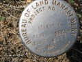
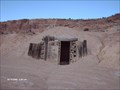
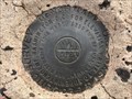
|   BLM SINKHOLE 1961, Emery Co., Utah BLM SINKHOLE 1961, Emery Co., Utah
in U.S. Benchmarks BLM SINKHOLE 1961, UT, is a BLM survey disk monumented at a sinkhole along the east side of Buckhorn Draw Road in Emery County, UT. posted by:  seventhings seventhings location: Utah date approved: 05/17/2006 last visited: 07/19/2012 |
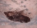 view gallery view gallerySW5.8 km |  Sinkhole on the San Rafael Swell Sinkhole on the San Rafael Swell
in Natural Sinkholes A Sinkhole in Sinkhole Flat posted by: robbdogg120 location: Utah date approved: 03/30/2007 last visited: 06/26/2009 |
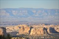
 view gallery view gallery E7.1 km E7.1 km
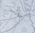
|  San Rafael Swell San Rafael Swell
in 'You Are Here' Maps You Are Here in the Black Dragon View Area at the eastern edge of the San Rafael Swell on Interstate Highway 70 about 15 miles west of Green River, Utah. posted by:  brwhiz brwhiz location: Utah date approved: 12/06/2012 last visited: 05/12/2016 |
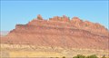 view gallery view galleryE7.1 km |  Black Dragon View Area Black Dragon View Area
in Scenic Roadside Look-Outs The Black Dragon View Area is located on the north side of Interstate Highway 70 about 15 miles west of Green River, Utah. posted by: brwhiz location: Utah date approved: 12/06/2012 last visited: 01/05/2023 |
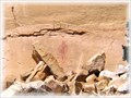
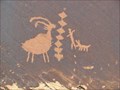 view gallery view galleryE11.6 km |  Petroglyph Canyon - Green River, Utah Petroglyph Canyon - Green River, Utah
in New World Ancient Evidence Two panels on a canyon wall in the San Rafael Swell. posted by: linkys location: Utah date approved: 05/08/2011 last visited: never |
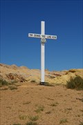 view gallery view gallery SE12.1 km SE12.1 km
|  Trooper Dennis Lavelle Lund Utah Highway Patrol Trooper Dennis Lavelle Lund Utah Highway Patrol
in Police Memorials Trooper Dennis Lavelle Lund Utah Highway Patrol Memorial posted by: kJfishman location: Utah date approved: 10/24/2010 last visited: 10/24/2010 |
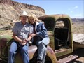
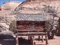
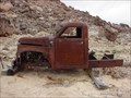 view gallery view galleryE14.6 km |  Truck - San Rafael Swell , Utah Truck - San Rafael Swell , Utah
in Abandoned Dead Vehicles A cool, old, dead truck we found while jeepin' in the San Rafael Swell. posted by: JacobBarlow location: Utah date approved: 04/22/2007 last visited: 06/04/2007 |
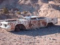 view gallery view gallery NW15 km NW15 km
| Bonie & Clide not in Abandoned Dead Vehicles dead car on the San Rafael Swell posted by: robbdogg120 location: Utah date approved: 04/09/2007 last visited: never |
 view gallery view galleryNW15 km | Dead Truck in Abandoned Dead Vehicles In San Rafael Swell posted by:  DeViDe DeViDe location: Utah date approved: 08/28/2005 last visited: 03/10/2007 |
 view gallery view galleryNW15.6 km |  Dexter cabin Dexter cabin
in Unoccupied Buildings, Shacks, and Cabins This cabin is near Dexter Mine
posted by: robbdogg120 location: Utah date approved: 03/10/2007 last visited: never |
 view gallery view galleryNW16.1 km |  San Rafael Swinging Bridge San Rafael Swinging Bridge
in U.S. National Register of Historic Places Suspension Bidge over the San Rafael River posted by: caverspencer location: Utah date approved: 03/27/2007 last visited: 03/27/2007 |
 view gallery view galleryNW16.1 km |  San Rafael Swinging Bridge San Rafael Swinging Bridge
in Utah Historical Markers Swing Bridge over the San Rafael River posted by: caverspencer location: Utah date approved: 03/27/2007 last visited: 06/14/2007 |
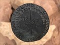
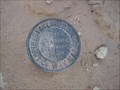 view gallery view galleryE16.1 km | Highway 24 and I70 in U.S. Benchmarks State road survey marker just off the junction of I-70 and Highway 24. posted by: caverspencer location: Utah date approved: 02/06/2007 last visited: 05/26/2023 |
![Image for [T23S R13E S1] T23S R14E S6 S7 CC - Emery County, Utah](https://img.geocaching.com/waymarking/small/97f16593-3d4d-4600-b0bb-4b108bf040a9.jpg) view gallery view gallerySE18 km |  [T23S R13E S1] T23S R14E S6 S7 CC - Emery County, Utah [T23S R13E S1] T23S R14E S6 S7 CC - Emery County, Utah
in Public Land Survey Marks A GLO closing corner marker to the east of the prominent San Rafael Reef. posted by: Tom.dog location: Utah date approved: 06/11/2023 last visited: never |
![Image for T23S R13E S1 S12 [T23S R14E S7] - Emery County, Utah](https://img.geocaching.com/waymarking/small/d5682e52-f750-4787-a2bf-78811c8d1802.jpg) view gallery view gallerySE18 km | T23S R13E S1 S12 [T23S R14E S7] - Emery County, Utah in Public Land Survey Marks A GLO section corner marker in the San Rafael Reef region of Emery County. posted by: Tom.dog location: Utah date approved: 06/11/2023 last visited: never |
 view gallery view gallerySE18.2 km | M 11 (JN0006) - Emery County, Utah in U.S. Benchmarks This benchmark is located roughly midway between State Highway 24 and the San Rafael Reef. posted by: Tom.dog location: Utah date approved: 06/11/2023 last visited: never |
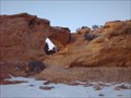
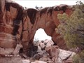 view gallery view gallery N18.2 km N18.2 km
|  Horse Heaven Arch Horse Heaven Arch
in Natural Arches A remote Arch posted by: robbdogg120 location: Utah date approved: 11/20/2006 last visited: 02/11/2006 |
 view gallery view gallerySE18.7 km | T23S R13E S12 R14E S7 - Emery County, Utah in Public Land Survey Marks This GLO quarter corner marker is monumented to the east of the expanse of the San Rafael Reef. posted by: Tom.dog location: Utah date approved: 06/11/2023 last visited: never |
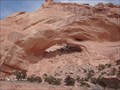
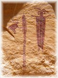 view gallery view gallerySW20.4 km |  Head of Sinbad Rock Art Head of Sinbad Rock Art
in Pictographs There are two Ancient Rock Art panels located here. One of the panels is sometimes referred as the 'Best Preserved' Pictographs of the Barrier Canyon style.
posted by: oldestar location: Utah date approved: 12/02/2006 last visited: 05/26/2006 |
 view gallery view gallery W21.9 km W21.9 km
| Cabin on Sid's Mountain in Unoccupied Buildings, Shacks, and Cabins This is a cabin I found on Sid's Mountain posted by: robbdogg120 location: Utah date approved: 03/05/2007 last visited: 03/03/2007 |
 view gallery view gallerySW22.2 km | Dutchman's Arch in Natural Arches This Arch is just off of I70 posted by: robbdogg120 location: Utah date approved: 01/16/2007 last visited: 10/30/2005 |
 view gallery view galleryW22.4 km | Slipper Arch in Natural Arches This Arch is in Coal Wash posted by: robbdogg120 location: Utah date approved: 04/19/2007 last visited: never |
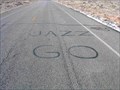 view gallery view gallerySE24.3 km |  GO JAZZ GO JAZZ
in Unusual Signs GO JAZZ done with crack sealing tar on the highway (Utah 24) posted by: mevans821 location: Utah date approved: 02/08/2011 last visited: never |
 view gallery view gallerySW24.5 km | Lone Warrior Rock Art in Pictographs Lone Warrior Rock Art is located in the San Rafael Swell area of Southern Utah. posted by: oldestar location: Utah date approved: 12/02/2006 last visited: 09/05/2007 |
 view gallery view gallerySW24.6 km | Ghost Rock View Area in Scenic Roadside Look-Outs The Ghost Rock View Area is located on the north side of Interstate Highway 70 about 35 miles west of Green River, Utah. posted by: brwhiz location: Utah date approved: 12/06/2012 last visited: 01/05/2023 |
|